September 16, 2021
No Coal in Alberta: an End-of-Summer Round Up and Look Ahead. Virtual Town Hall – September 16, 2021
On September 16, 2021, AWA, in collaboration with the Coal Policy Working Group, hosted the…


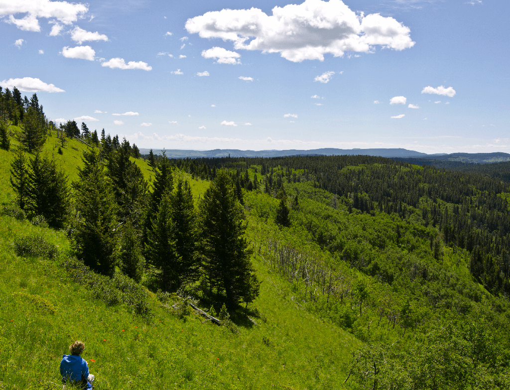
With rolling hills of native grasses, old growth forests, and towering mountains, the Livingstone-Porcupine is one of the most diverse and iconic regions of Alberta.
The Porcupine Hills in spring. PHOTO: © K MIHALCHEON
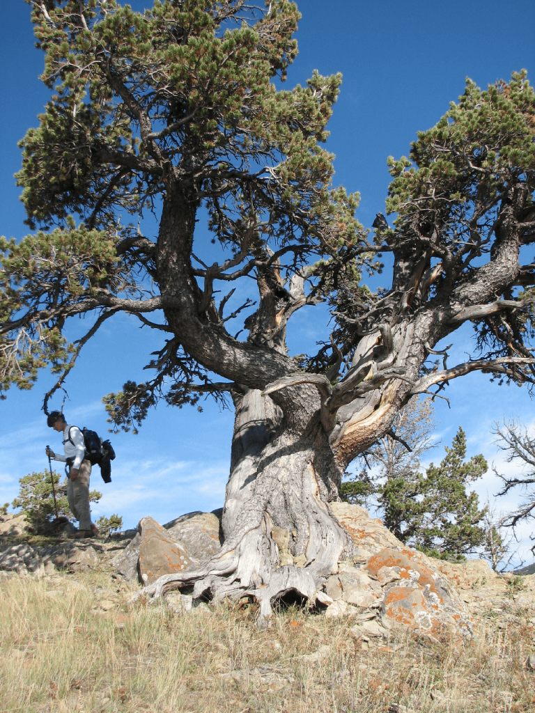
Limber pine on the Whaleback. PHOTO: © AWA FILES
The mighty Livingstone range. PHOTO: © AWA FILES
AWA believes the Livingstone-Porcupine must be managed in a way that ensures healthy watersheds that support the unique biodiversity of this region for generations to come. AWA supports the recent undertaking of sub-regional planning and establishment of Public Land Use Zones (PLUZs). The Biodiversity Management Framework is urgently needed to manage all human footprint on the landscape.
 |
 |
The foothills of the Livingstone-Porcupine area mark a clearly identifiable landmark for Albertans and a stronghold for biodiversity in the Eastern Slopes. PHOTO: © S. BRAY |
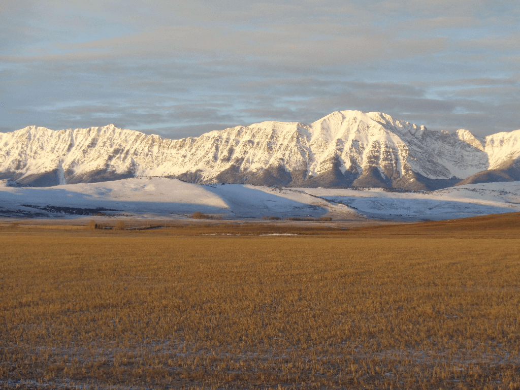
The Livingstone-Porcupine – it begins just south of Kananaskis and extends all the way to the Crowsnest Pass. It’s a key area of connectivity for grizzly bears and elk; its fescue grasslands are important for ranching and conserving species at risk; it previously boasted many healthy populations of native fish. It’s one of the most iconic and diverse landscapes in Alberta.
The 4,560 km2 Livingstone-Porcupine area is found along the Southern Eastern Slopes of the Rocky Mountains. The area can be divided into four major identifiable regions, each with their own unique ecological and geographical features:
Livingstone (West)
Boasts an impressive mountain range by the same name, as well as the areas flanking the west side of the Forestry Trunk Road. Along with the area encompassed by the Whaleback, the protected areas of the Livingstone (the Don Getty Wildland Provincial Park, Beehive Natural Area, and Mt Livingstone Natural Area) and the Livingstone Public Land Use Zone offer one of the province’s most important wintering ranges for elk.
Whaleback (Central)
East of Livingstone is the Whaleback, an affectionately named 30 km stretch of foothills resembling a beached humpback whale. The Whaleback includes portions of the Bob Creek Wildland and Black Creek Heritage Wildland, and supports the largest undisturbed tract of Montane landscape in Canada.
Crowsnest (South)
The Crowsnest region borders the municipal area along Highway 3, containing a string of small towns (Coleman, Blairmore and Bellevue). The Crowsnest is particularly well-known for its powerful mountains, the Crowsnest Mountain and Seven Sisters, as well as the world-class fly-fishing offered by the Crowsnest River.
Porcupine Hills (East)
The Porcupine Hills are found east of Highway 22. The Porcupine Hills hold a rich mosaic of vegetation and are popular for their hunting grounds, hiking paths and horse packing.
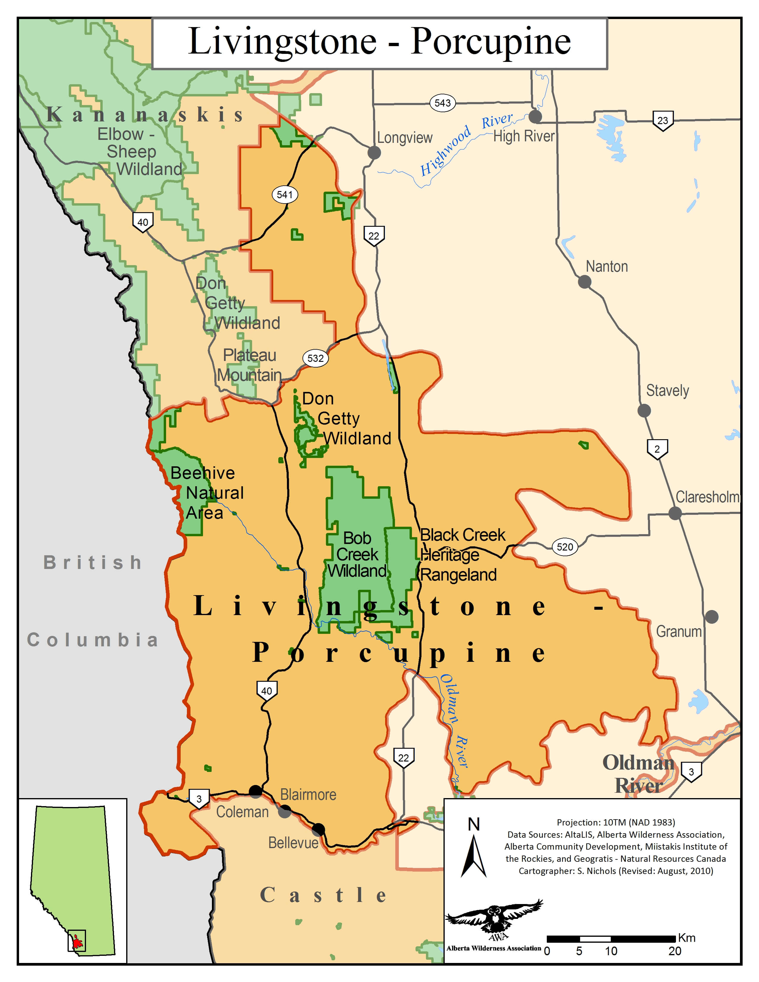
 Livingstone-Porcupine Area of Concern. MAP © AWA: JPG| PDF
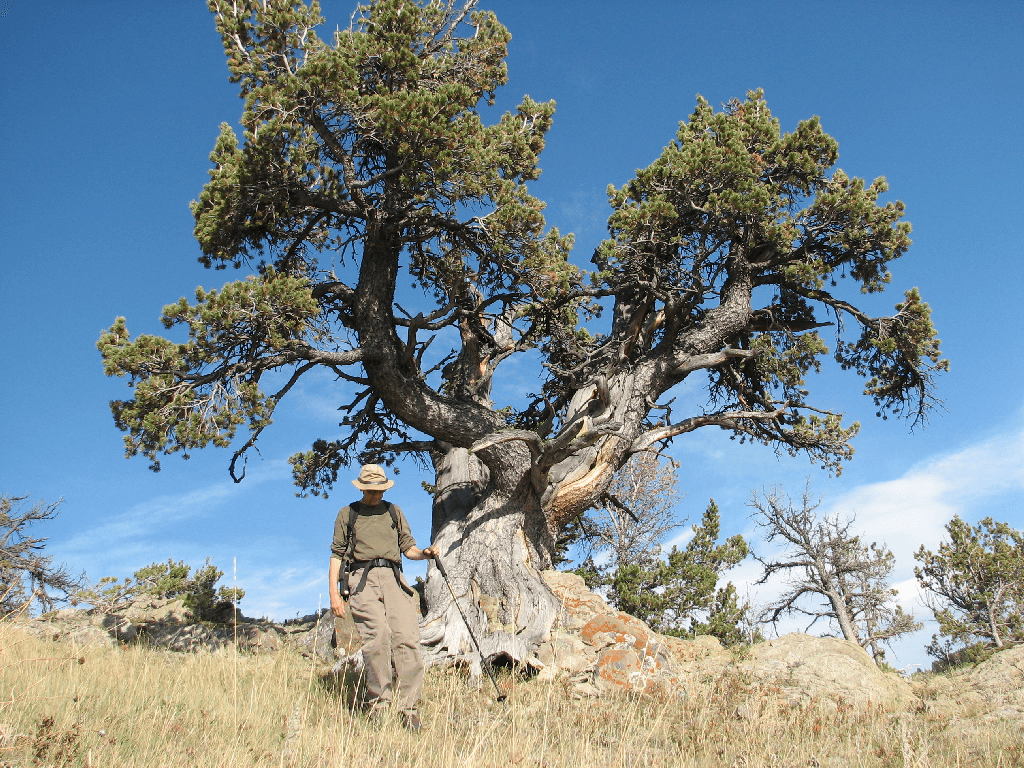
Together, these areas mark a key component of the Crown of the Continent ecosystem, supporting some of the most diverse ecosystems in Alberta. In the Porcupine Hills alone there are five distinct vegetation types (grassland, parkland, montane, subalpine and alpine); nowhere else in Alberta do these vegetation types coexist in such close proximity. The area’s biodiversity supports a number of species that are endangered, threatened or of special concern, including grizzly bear, westslope cutthroat trout, bull trout, limber pine, and white bark pine.
Public Lands
Public lands have suffered the same fate as many other public lands in Alberta; a decades-long pattern of neglect has fueled an uncontrolled explosion of cutblocks, pipeline right-of- ways, seismic lines, and motorized use. This story is not unique to the Livingstone-Porcupine: many of Alberta’s public lands are currently suffering from decades of inaction resulting in excessive linear disturbance on the landscape.
AWA supports the government’s recent completion of sub-regional plans for linear footprint and motorized recreation along with the establishment of two Public Land Use Zones (PLUZs): the Livingstone PLUZ, to the west, and the Porcupine Hills PLUZ, to the east. These plans provide the tools and mechanisms to responsibly manage our public lands by establishing legislative limits on land uses, including industrial activity and motorized recreation, and determining where such activities would be appropriate.
There are still no limits placed on all remaining human footprint, including coal mines and industrial scale logging. AWA believes the completion of the Biodiversity Management Framework – which will place legislative limits on spatial human footprint – is urgently needed.
The majority of the Livingstone-Porcupine area is composed of public lands, which contains the Livingstone and the Porcupine Hills Public Land Use Zones (PLUZs). These PLUZs were established on May 15, 2018 and fall under the authority of the Public Lands Administration Regulation.
The area also contains a number of Provincial Parks and Protected Areas, including:
Public Lands
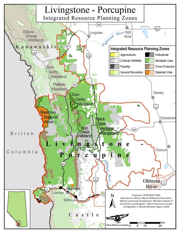
The Livingstone-Porcupine region is managed under the South Saskatchewan Regional Plan (SSRP) 2014-2024 under the Alberta Land Stewardship Act (ALSA). Sub-regional planning (in this case, the Linear Footprint and Recreation Management Plans) replaced previous land-use plans such as the Eastern Slopes policy and Integrated Resource Plan (IRP). Although sub-regional planning was implemented in the spring of 2018, the direction of land-use will continue to be set by the 1987 Integrated Resource Plan (IRP) until all provisions have been reviewed. The IRP for Livingstone-Porcupine Hills was previously in place to guide, rather than regulate, land managers towards leveraging the greatest economic benefit from the area’s natural resources. 83 percent of the IRP provisions align with current plans and directions, while the remaining 17 percent of provisions will be re-evaluated in the Land Footprint and Recreation Management Plans, the SSRP, or other regional management plans and guidelines.
Since 2018, the Livingstone-Porcupine Hills Land Footprint Management Plan (LFMP) and Recreation Management Plan (RMP) have been in effect. Management objectives from the LFMP and RMP include: maintaining valued ecological components (such as headwaters and biodiversity), protecting threatened species, providing sustainable outdoor recreation opportunities, and acknowledging and maintaining First Nations land uses.
The development of a Biodiversity Monitoring Framework (BMF) has been scheduled for completion since fall of 2016. The BMF is to be developed under the SSRP to support the conservation of regional biodiversity through the management of cumulative effects – namely, spatial human footprint. From this framework a number of biodiversity indicators (key species, important habitats and landscapes) will be outlined, monitored and used as triggers for action.
 Livingstone-Porcupine IRP map. MAP © AWA: JPG | PDF
Protected Areas
The provincial parks and protected areas of Livingstone-Porcupine Hills are delineated under the South Saskatchewan Regional Plan and are zoned under ‘Zone 1 – Conservation’. These areas are primarily managed under two acts: the Provincial Parks Act and the Wilderness Areas, Ecological Reserves, Natural Areas and Heritage Rangelands Act.
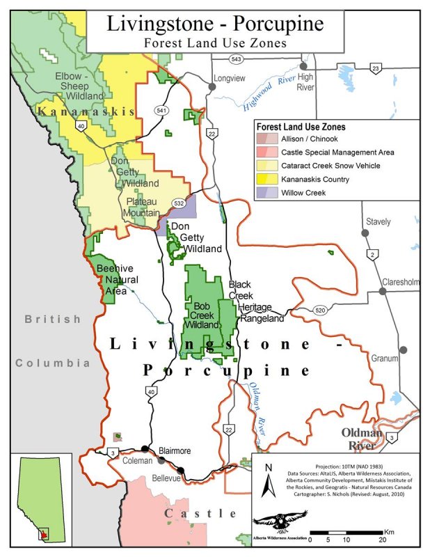
Forests
Forests in the Livingstone-Porcupine region fall under the C5 Forest Management Unit and are governed by the C5 Forest Management Plan (FMP).
 Livingstone-Porcupine FLUZ map. MAP © AWA: : JPG | PDF
Oil and gas
Oil and gas operations in the region are regulated by Alberta Energy Regulator (AER)’s Informational Letter IL 93-9 which lays out the expectations for oil and gas companies working in the Eastern Slopes.
The Livingstone-Porcupine area covers 4,560 km2 of the Southern Eastern Slopes, stretching south of Kananaskis to north of Castle. The area can be accessed by the Cowboy Trail (Highway 22) and via Highway 3. Nearby the municipalities include Coleman, Blairmore and Bellevue to the south, and Pincher Creek to the southeast. The area contains a number of recognizable sub-regions, including:
Livingstone (West)
Boasts an impressive mountain range by the same name, as well as the areas flanking the west side of the Forestry Trunk Road. Along with the area encompassed by the Whaleback, the protected areas of the Livingstone (the Don Getty Wildland Provincial Park, Beehive Natural Area, and Mt Livingstone Natural Area) and the Livingstone Public Land Use Zone offer one of the province’s most important wintering ranges for elk.
Whaleback (Central)
East of Livingstone is the Whaleback, an affectionately named 30 km stretch of foothills resembling a beached humpback whale. The Whaleback includes portions of the Bob Creek Wildland and Black Creek Heritage Wildland, and supports the largest undisturbed tract of Montane landscape in Canada.
Crowsnest (South)
The Crowsnest region borders the municipal area along Highway 3, containing a string of small towns (Coleman, Blairmore and Bellevue). The Crowsnest is particularly well-known for its powerful mountains, the Crowsnest Mountain and Seven Sisters, as well as the world-class fly-fishing offered by the Crowsnest River.
Porcupine Hills (East)
The Porcupine Hills are found east of Highway 22. The Porcupine Hills hold a rich mosaic of vegetation and are popular for their hunting grounds, hiking paths and horse packing.
Livingstone-Porcupine Area of Concern. MAP © AWA: JPG| PDF
The Livingstone-Porcupine area is part of the South Saskatchewan drainage system, including surface drainage from Highwood River tributaries, Willow Creek, Oldman River, Crowsnest River and Castle River; of these, the Oldman River is the largest drainage basin. The Oldman is significant to Southern Alberta for the high percentage of water that it supplies for communities downstream, the habitat it provides to fish and wildlife populations (e.g. threatened westslope cutthroat trout and bull trout), and its cultural and historical significance to the Indigenous peoples of the area, namely the Blackfoot.
Livingstone-Porcupine is composed of two major geologic regions: the Cordilleran and the Interior Plains. The Cordilleran is made up of complex folds, normal faults and thrust faults, while the Interior Plains are composed of relatively flat-lying strata. Sandstone and shale are common rock exposures, although carbonates form many of the area’s more prominent ridges.
The Porcupine Hills are underlain by very gently tilted and easterly-dipping beds of sandstone and shale as part of the Porcupine Hills Formation. Unlike the dramatically folded and faulted rocks of the Foothills and Rocky Mountains, the primary structural feature of the Hills is a broad, shallow syncline, structurally more similar to the plains. Although parts of the south-central segments of the Porcupine Hills escaped continental glaciation, two major ice sheets migrated into, around and through the Hills from the north, east and south. This glacial activity resulted in carving of long, flat valleys and large, deep bedrock coulees and channels along parts of the eastern margin.
Portions of the Livingstone-Porcupine area have been designated as either provincially or nationally environmentally significant areas (ESAs). These ESAs boast old-growth forests over 400 years old and key low-elevation corridors for east-west migration.
 Livingstone-Porcupine ESA map. MAP © AWA: JPG | PDF
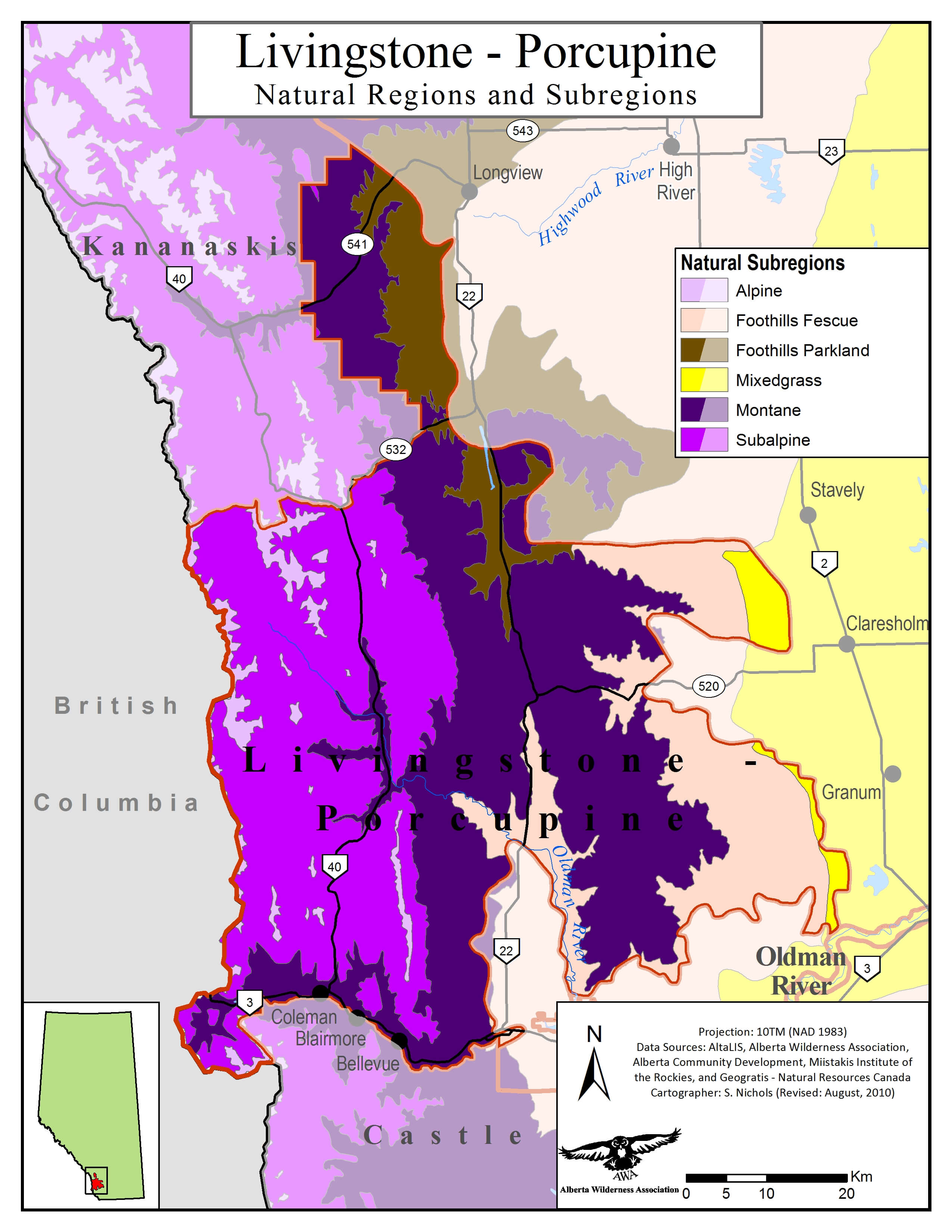
The Livingstone-Porcupine area is found within three of Alberta’s natural regions: Rocky Mountain, Parkland and Grassland. These natural regions contain five sub-regions: Montane, Sub-Alpine, Alpine, Foothills Parkland, and Foothills Fescue.
 Livingstone-Porcupine Natural Subregions. MAP © AWA: JPG |PDF
Fescue grassland: Rough fescue, Parry oat grass, timber oat grass, Idaho fescue, sticky geranium, perennial lupine
Aspen parkland: Aspen, veiny meadow rue, northern bedstraw, wild strawberry, Saskatoon, willow, fireweed, prairie smoke
Montane: Douglas fir, white spruce, limber pine, thimbleberry, creeping mahonia, buffalo berry, bearberry, snowberry
Subalpine: Lodgepole pine, Engelmann spuce, twinflower, grouseberry, pine grass
Alpine: Krummholz of whitebark pine, grouseberry, mountain avens, snow willow, moss campion, kobresia, bear grass, black alpine sedge
Limber pine. PHOTO: © S. BRAY
Rough fescue. PHOTO: © S. BRAY
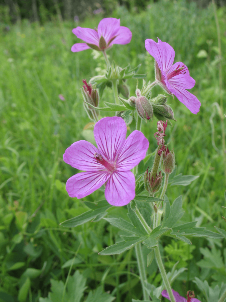
Sticky purple geranium. PHOTO: © J. HILDEBRAND
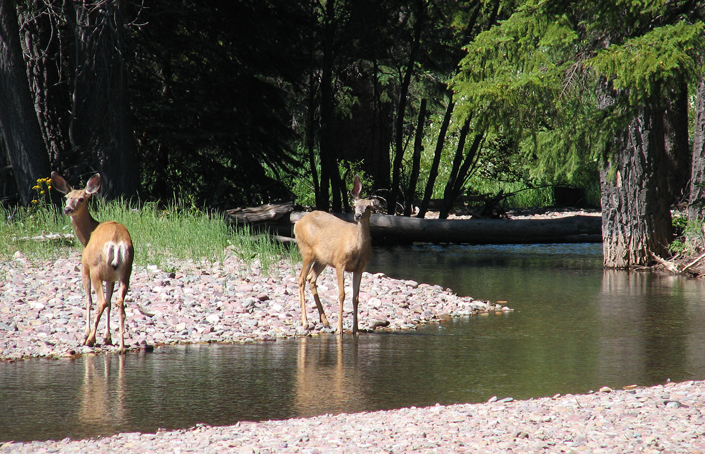
Ungulates, including elk, moose, mule deer and white-tailed deer, frequent the area, including the largest elk herd found entirely outside of a national park. The diverse terrain and forage have also made the Livingstone-Porcupine a major area for cougars, particularly among the rock outcrops in the North Porcupine Hills. Other mammals in the area include black bears, grizzly bears, wolves and lynx, and a variety of birds can be observed, including the Lazuli bunting, Cassin’s finch, and blue grouse.
Wolves have profound effects on whole ecosystems, and are capable of completely reshaping them. We believe it is important to maintain at least small populations of wolves along the Southern Eastern Slopes to prevent the kind of deeply transformative ecosystem disruption caused by trophic cascades, as found in the Greater Yellowstone Ecosystem after wolves were extirpated there.
The waters of the Livingstone-Porcupine are important spawning areas for native trout species, including threatened westslope cutthroat trout (federally listed) and bull trout. Both species of trout are limited by a number of, primarily human, factors. These factors include habitat fragmentation and degradation, roads, invasive species, pollution, and climate change. Many of these factors are the result of the cumulative impacts of industrial use (i.e. forestry & oil and gas) and motorized recreation. AWA strongly asserts that new developments (e.g. roads, trails, transmission lines, pipelines, well sites, buildings, fences, bridges) pose a continued threat to critical trout habitat, and reiterates that there is a legal responsibility to protect westslope cutthroat trout under the Species at Risk Act.
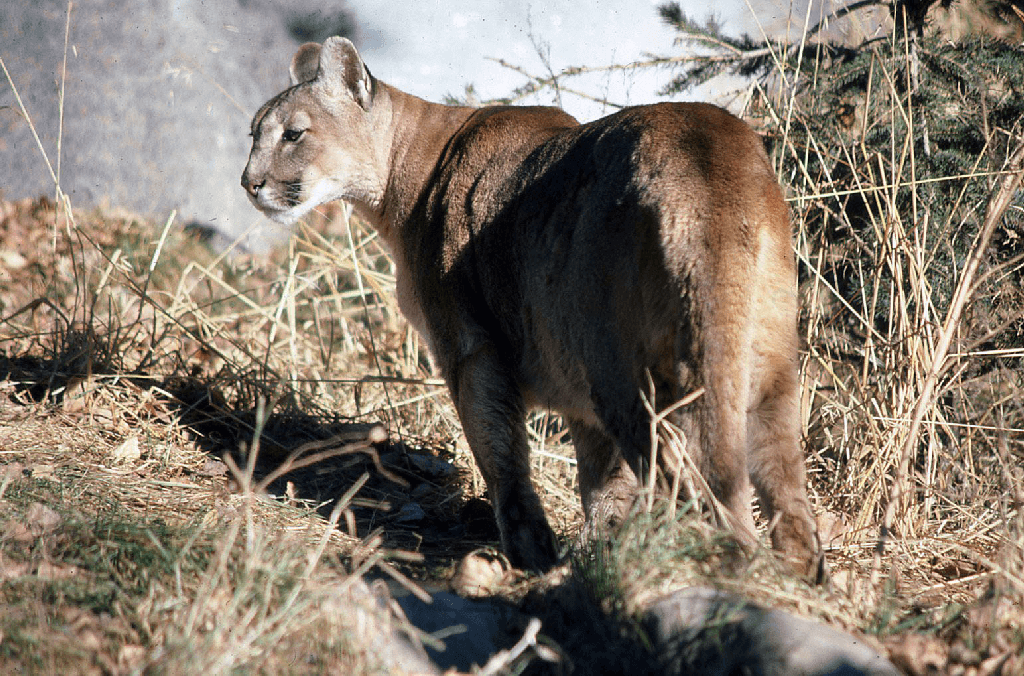
Cougar. PHOTO: © I. ROSS
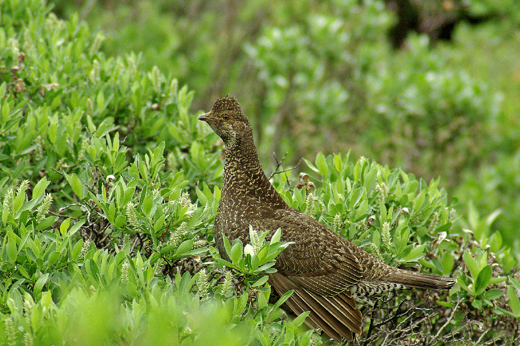
Blue grouse. PHOTO: © AWA FILES
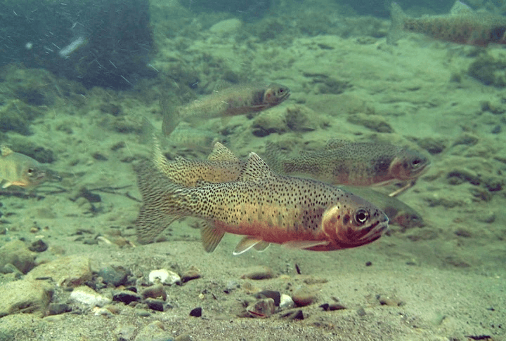
Westslope cutthroat trout. PHOTO: © AWA FILES
This area falls within the traditional territory of Treaty 7, and is marked by the historical uses of the Blackfoot Confederacy (Siksikaitsitapi), consisting of Kanai, Siksika, and Piikani, for hunting and winter camps. There were buffalo jumps in various places within the Porcupine Hills until the buffalo herds were nearly extirpated in the 1880s.
The area was explored and recorded by the Palliser Expedition led by Captain Thomas Blackiston (1858), Robert Dawson, a British surveyor (1884), and by provincial boundary surveyors in 1915. Colonel Robertson-Ross, Commanding Officer of the Canadian Militia, travelled through the area in 1872 en route to the North Kootenay Pass, where he and his crew were trapped by a violent snowstorm for 6 days in the North Porcupine Hills.
In 1903, tragedy struck as a rock slide buried the town of Frank in 110 million tonnes of limestone and shale, killing 90 people.
The Provincial Parks, Natural Areas and Public Lands of the Livingstone-Porcupine area host a variety of recreational activities, in both the front and backcountry. The Public Land Use Zones offer motorized and non-motorized trail systems. Some areas have been designated for non-motorized use due to past conflicts that have arisen between non-motorized recreational users (i.e. hikers, campers and equestrians) and motorized vehicle users.
Provincial Parks, such as the Chain Lakes Provincial Park, offer more day-use activities, like fishing, kayaking, wind surfing and birding, whereas the Natural Areas, like Beehive, offer more backcountry opportunities for hiking, camping, horse riding, and hunting.
Significant abuses of public lands within the Livingstone-Porcupine have been documented, with an incredible proliferation of roads, industrial development and industrial scale logging which is all utilized by motorized recreationists.
As of January 2018, there are currently 4,053 km of linear features in the Livingstone-Porcupine Hills with an average trail density of 2.28km/km2. There is no question these ecosystems are damaged and reducing the linear density is necessary.
AWA supports the government’s recent establishment of Public Land Use Zones (PLUZs) and completion of sub-regional planning initiatives in the area. PLUZs are fundamental to the conservation of public land, as within their boundaries wildlife officers have the authority to issue tickets for damaging public land; an authority that does not exist on public land not designated as a PLUZ or Public Land Recreation Area (PLAR). Issuing tickets, rather than sending offenders to court, reduces the amount of time it takes to remove harmful behaviour from the land. However, in order for PLUZs to be effective mechanism for conservation, infringements need to be strictly enforced to ensure that lawless and destructive behaviour does not continue to fall under the radar.
There are still no limits placed on all remaining human footprint, including coal mines and industrial scale logging. AWA believes the completion of the Biodiveristy Management Framework – which will place legislative limits on spatial human footprint – is urgently needed.
Increasing volumes of off-highway vehicle (OHV) use have resulted in the degradation of land and water in Alberta’s Eastern Slopes. OHV use can deteriorate riparian habitat, diminish downstream water quality, degrade fish habitat, disturb critical habitat for grizzly bears and deter other recreational users from the area. The exacerbation of linear disturbances, particularly in the Public Land Use Zones, is further reducing viable habitat for at risk species, such as the westslope cutthroat trout and grizzly bear. The “lawless behaviour” exhibited by some OHV-users has also served as a deterrent for other less-disruptive forms of tourism (e.g. equestrian use and hiking).
In general, AWA is supportive of safe and responsible use of motorized recreational vehicles on designated trails in appropriate areas that do not impact other recreational users, vegetation, water or wildlife. AWA believes comprehensive recreation planning must take into account the proportionality of use for the needs of all Albertans including non-motorized recreationists, landowners, and downstream users.
AWA believes the Recreation Management Plan (RMP) and newly designated trails will help to address years of uncontrolled motorized recreation. AWA appreciates the importance of the RMP for acknowledging recreational use as one of the main contributors to the human footprint of the area, however finds that outcomes are weakly defined and the plan contains few, if any, measurable indicators relating to enhancing watershed integrity, biodiversity values and wildfire risk. For the RMP to be effective, AWA recommends minimizing recreational impacts to the watershed through enforcing trail closures, limiting stream crossings and closely monitoring intensity of use. Enforcement and education are key components to the effective implementation of the RMP.
The newly designated trail network helps protect important watersheds such as the upper Oldman and Hidden Creek by avoiding OHV use in these areas. The restrictions will benefit westslope cutthroat trout and bull trout populations, native plants, ungulates, and provide opportunities for other forms of recreation.

An example of damages incurred on the stream bed and riparian area by OHV use. PHOTO: © AWA FILES.
Introduction of non-native invasive plants is one of the biggest long-term risks to native fescue grasslands. Industrial roads and seismic lines represent ‘inoculation routes’ for invasive species, which then spread out into surrounding native grasslands.
Species of fish, such as bull trout and westslope cutthroat trout, have suffered from the introduction of non-native species to the area. Through a combination of habitat degradation, migratory barriers and interbreeding, bull trout populations have been reduced to 33 percent of their original distribution in the Oldman River watershed.
Oil and gas, and mining of coal and uranium have been prominent land uses in the Livingstone and Porcupine in the past. There has been a lack of consideration of cumulative effects in previous land use plans, resulting in a piecemeal approach often called “death by a thousand cuts”. The Livingstone-Porcupine Hills Land Footprint Management Plan (LFMP) has promised to integrate coal categories from the South Saskatchewan Regional Plan, which may extend into an updated strategy for Coal Policy by the Alberta Energy Regulator. AWA believes that any review and incorporation of these policies into the LFMP should ensure that the outcome is at least as protective, if not more protective, than these policies given our increased knowledge of the vital importance of headwaters areas.
The 5-year performance reports from Alberta Environment and Protected Areas (AEPA) on the progress of the Livingstone-Porcupine Hills Land Footprint Management Plan (LFMP) and Recreation Management Plan (RMP) are due this year. A 1 – 3 year operational transition was expected when the plans were implemented in 2018, which was allocated to develop multiple tools to evaluate progress, including,
However, none of these tools, nor annual tracking or reports for either plan, been published publicly, despite both the LFMP and RMP outlining the necessity of robust monitoring, evaluation, and reporting to effectively execute the plans, stating that “reports will provide evidence that progress is being made towards achieving the outcomes and will adequately communicate progress on metrics”.
Strong accountability, transparency, and communication were highlighted as essential to successful land management. The only updates so far have come in the form of biannual Public Land Use Zone (PLUZ) maps, released at the start of summer and winter each year. Comparing maps from 2018-2023 shows decisions are being made to add, remove, and redesignate motorized trails each year, but the process and reasoning for these decisions is notably absent.
In June, the proposed Grassy Mountain Coal Mine, located within AWA’s Livingstone–Porcupine Area of Concern, is rejected by the joint provincial–federal review panel, following panel hearings that AWA participated in throughout 2020.
In February, a recommendations report was produced and completed by the Castle-Livingstone-Porcupine Hills Recreation Advisory Group. Given the diversity of representatives on the Advisory Group and that it was not a consensus–based process, recommendations varied in their direction and alignment with conservation objectives. Alberta Environment and Parks planning staff and Minister Nixon will review the recommendations and we expect a decision from the Minister in Fall.
AWA still awaits the completion of the cumulative effects planning in the Livingstone–Porcupine Hills under the Spatial Human Footprint Targets.
In March, ALCES and Lorne Fitch published the Cumulative Effects of Land Uses and Conservation Priorities in Alberta’s Southern East Slope Watersheds, a report focused on the impacts of industrial and recreation activities on native trout and grizzly bear habitat in the Livingstone–Porcupine region. In support of this study, AWA supported the work with administrative and financial services and facilitated a workshop on the report’s findings.
In fall, under new directions from the Minister, the RAG broadens their focus beyond the Livingstone and Porcupine Hills PLUZs to include the Bob Creek Wildland Provincial Park, Black Creek Heritage Rangeland and the two Castle Parks. The scope is expanded to “explore opportunities for a regional trail network” and consider changes to the existing management plans. AWA opposes the expanded scope as the management plans for the Livingstone–Porcupine Hills and Castle had already been completed with significant public consultation and scientific review, and changes to the plans could weaken existing environmental protections.
In June, the Crown finds the Brooks Motocross Club guilty under the Species at Risk Act and the Fisheries Act for crossing North and South Racehorse Creeks several times during a motocross race in 2014, seriously harming and causing the death of young bull trout and threatened westslope cutthroat trout. The group is fined $70,000 for habitat destruction. This decision is important, as it recognizes the importance of Alberta’s threatened native trout species and reinforces that we are all responsible for their protection and recovery.
Alberta Environment and Parks releases the Livingstone-Porcupine Hills Land Footprint Management Plan and Recreation Management Plan under the South Saskatchewan Regional Plan. These sub-regional plans will replace previous land-use plans such as the Eastern Slopes policy and Integrated Resource Plan (IRP). AWA staff comment on the plans in an article in the Wild Lands Advocate and a letter addressed to the Land-use Planning team for SSRP at Alberta Environment and Parks.
In August, the Canadian Environmental Assessment Agency (CEAA) issues another request for additional information to Benga Mining in order to fulfill environmental impact statement (EIS) requirements. A Joint Review Panel for the environmental assessment is established, with panel members being appointed. The Panel holds a public comment period on “the sufficiency and technical merit” of the EIS to determine whether it has enough information to proceed with a hearing. AWA provides comments to the Expert Panel in January of 2018, requesting more information with regards to the anticipated impacts of the project to species at risk, cumulative effects, and interactions with watershed hydrology.
The federal Canadian Environmental Assessment Agency (CEAA) receives Benga Mining’s (a subsidiary of Riversdale Resources) addendum for the Grassy Mountain mine project. Benga Mining is required to provide answers to CEAA’s information requests.
December: following Benga Mining’s most recent submission of an Environmental Impact Assessment (EIA), CEAA requests additional information including bat surveys, fish and aquatic surveys, westslope cutthroat trout information, induced seismicity, and cumulative effects under a separate addendum.
August: Benga Mining (a subsidiary of Riversdale Resources) submits an updated environmental impact assessment to CEAA.
June: Recreation management planning consultation begins.
May: AWA receives notice from AltaLink that the application for Castle Rock Ridge to Chapel Rock Transmission Project has not been submitted, as a direction from Alberta Electric System Operator (AESO) is needed first.
April: The famous King Ranch located along the Cowboy Trail is added to the Waldron Conservation Project with the Nature Conservancy of Canada, the largest conservation easement in Canadian history. This will help connectivity between the Bob Creek Wildland Park and Porcupine Hills.
February: The Livingstone and Porcupine Hills is the first area to undergo sub-regional land-use planning under the South Saskatchewan Regional Plan. Despite the Biodiversity Management Framework still in draft form, stakeholder consultation begins for the Linear Footprint Management Plan. AWA participates in an informal coalition of stakeholders in the Porcupine Hills, including ENGOs, landowners, municipalities, and concerned individuals.
August: Benga Mining Limited, a wholly owned subsidiary of Riversdale Resources Limited, proposes to develop and operate an open-pit metallurgical coal mine near Blairmore in the Crowsnest Pass. A loose coalition of environmental groups formed the Friends of Grassy Mountain for the purpose to share information and raise awareness about the risks of the mine. The federal Environment Minister announces the assessment will be handed over to an independent review panel.
March: The Southern Foothills Study is published. The purpose of the study was to examine whether application of Beneficial Management Practices would halt or reverse the decline in environmental indicators.
February: A feature article by AWA staff exposes that 10 government-authorized OHV racing events have taken place on public lands within Livingstone-Porcupine. No post-event field inspections, registration fees, or government attendance is required for the Temporary Field Authority (TFA) permits.
January: Concerns from local landowners are ongoing about the Castle Rock Ridge to Chapel Rock transmission project. The project proposes to connect electricity from wind energy projects and would pass through a culturally and ecologically unique area.
December: Despite AWA’s concerns, logging at Star Creek begins days before Christmas.
September: AWA writes to Minister Campbell opposing Southern Rockies Watershed Project Logging in Upper Star Creek Valley, due to concerns about westslope cutthroat trout, linear disturbance, and unproven need for the project.
AltaLink commits to investigating the death of dozens of ducks that were found underneath a one-year old AltaLink transmission line near Pincher Creek.
December: AWA writes to AESRD Minister Campbell updating him on concerns about the past 18 months’ logging operations in Hidden Creek in the Livingstone-Porcupine. Hidden Creek provides spawning habitat to 80 percent of the Oldman Basin pure-strain population of westslope cutthroat trout.
October: The draft South Saskatchewan Regional Plan proposes that the Beehive Natural Area be designated as a Wildland Provincial Park. As such there would be no oil and gas activity, mining, commercial forestry or off-highway vehicle activity allowed. Plan also proposes expansions to other parks, including Blue Rock and Bob Creek Wildlands.
September: AWA finally receives information requested in November of 2012 under Freedom of Information (FOIP), concerning logging in Hidden Creek.
July: A report by Wildlife Conservation Society Canada biologist John Weaver examines the latest science on conservation needs of six species in the southern Canadian Rockies headwaters, and threats posed to them by climate change and road access. Weaver recommends new Wildland Provincial Parks in the Oldman River and Highwood River headwaters to address future habitat needs.
January: AWA writes to the Minister of AESRD to express concern about failure of logging in Hidden Creek to comply to appropriate conditions. A 2-km stretch of road has been constructed within the 100-metre buffer required for ‘Class A’ streams such as Hidden Creek.
Suncor Energy announces that it has discontinued all pipelines and facilities in its Savanna Creek area and is currently in the process of suspending all wells in the area. This includes the long-established sour gas wells on and around Plateau Mountain Ecological Reserve.
AESRD approves Spray Lake Sawmills logging plans along a stretch of Hidden Creek, in the Upper Oldman Basin. Hidden Creek is one of the most critical spawning grounds in southern Alberta for both Westslope Cutthroat Trout and the threatened Bull Trout. AWA writes to the Alberta Government objecting to this operation and makes a FOIP request for related information. The logging goes ahead as approved and proceeds through January 2013.
December: In a highly significant decision, the Alberta Utilities Commission (AUC) refuses permission to Altalink Management Ltd. to build a new transmission line in the pristine landscape of southwestern Alberta’s Livingstone Range. The commission agrees with AWA and other opponents to the application that a previous “needs” approval for a different area did not entitle the company to develop anywhere they wished.
Peter Sherrington represented AWA at the August pre-hearing, and commented at the time that the case commented at the time that the issue was as “close to a no-brainer” as he’s seen. After the AUC’s decision, he wrote “The important thing about this ruling is that it has restored ordinary citizens’ faith in the process of regulation.”
November: The local passion for the Southern Foothills landscape is once again underlined with the recent publishing of the results from the Southern Foothills Community Stewardship Initiative (SFCSI), a year-long grassroots initiative led by the Pekisko Group and the Chinook Institute for Community Stewardship. The report, Values and Voices: Stewardship Priorities for the Southern Alberta Foothills, is released in November 2011.
August: Alberta Utilities Commission (AUC) holds pre-hearing for application by the Alberta Energy Systems Operator (AESO) and Altalink to build 240 kV transmission lines through the Livingstone. AWA argues that the development proposals contradict commitments made on numerous occasions by Altalink President and Chief Executive Officer, Scott Thon.
Previously AUC had granted a “needs” approval to AESO. This recognized the “need” for a new transmission line running from Goose Lake, near the Oldman Dam, west to the Crowsnest Pass. Since receiving “needs” approval for that specific corridor, Altalink has proposed a dizzying number of alternative locations and routes for substations and transmission lines, including options far beyond the route for which they originally received permission. AWA believes that receiving “needs” permission for one particular route should not give Altalink carte blanche to build transmission lines wherever they want in southern Alberta without due process.
April: The Alberta government refers the proposed Micrex magnetite mine to the Natural Resource Conservation Board for review. The Board seem taken by surprise by the announcement. Government promises the Calgary Herald that “the board will seek public comments on the Micrex project.”
February: Altalink announces proposals to build new transmission lines in the Livingstone region. AWA writes to Premier Stelmach to oppose the proposed development.
January: In an interview with the Calgary Herald’s Kelly Cryderman, Ted Morton, Minister of Finance, wades in to the debate over the proposed Micrex Corp. magnetite mine on the flanks of the Livingstone Range. He urges Minister Mel Knight, (Morton’s successor as Minister of Sustainable Resource Development), not to approve the proposed mine, at least not until the Land-Use Framework plan for the South Saskatchewan region is finalized.
November: The Pekisko Group and the Chinook Institute for Community Stewardship launch the Southern Foothills Community Stewardship Initiative. A series of community workshops is held to research the values and priorities held by residents throughout the region.
October: AWA writes to Premier Stelmach to express opposition to the proposed Micrex magnetite mine on the Livingstone Range.
Alberta Environment unexpectedly decides that no Environmental Impact Assessment would be required for Micrex Corp’s proposed magnetite mine on the flanks of the Livingstone Range. This is despite considerable local opposition to the proposed mine, which would have significant effects on the local environment, including bighorn sheep nursing grounds and elk wintering grounds, not to mention a spectacular viewscape.
September: With surprising speed, a draft management plan for the new Heritage Rangeland is made available for public input.
August: The 4,277-hectare OH Ranch Heritage Rangeland is officially designated. In an agreement with the Alberta government, owners of the OH Ranch agree to put conservation easements on their own deeded land if the Alberta government will designate the adjacent land (for which the OH Ranch holds a grazing lease) as a Heritage Rangeland. Although it appears that donations by private landowners now seem to be the only available way of protecting new land in Alberta, this is an encouraging step, which will help to protect a large area of relatively pristine fescue grassland for the foreseeable future.
December: EUB pulls the plug on the revision and strengthening of the Information Letter IL93-9 after seeing the participation of AWA and three landowner groups. Instead, at a public meeting on December 3, EUB announces its new Early Engagement Land Pilot project for the area. Two hundred local residents listen respectfully to 15 members of EUB introduce the project. Participants then stand up, one by one, and reject the proposals. They call for a moratorium on further development until a plan can be developed to address the cumulative effects of numerous activities on the landscape. John Cross, from the Pekisko Group, calls for the government to “Stop. Think. Plan intelligently.”
April: AWA joins 13 environmental and landowner groups in sending a letter to Premier Stelmach regarding the concept of a pause, or a “time out” for many resource developments in the Southern East Slopes.
March: Work on the Southern Foothills Study continues. Phase Three of the Study begins. Different groups begin to meet to discuss best practices for the different “sectors” operating in the region – e.g.: oil and gas, forestry and agriculture. AWA is represented on the Forestry Sector group, which has one single belated meeting in November.
Various minor land exchanges take place, prior to finalizing boundaries of protected areas (Bob Creek Wildland and Black Creek Heritage Rangeland). Upper Bob Creek Ecological Reserve disestablished, having been incorporated into these two new protected areas.
October: The Southern Foothills Study cumulative effects report is released. A series of presentations in seven local communities attracts 600 people.
June: Following a pre-hearing in April, Alberta Energy Utilities Board (EUB) denies standing to AWA and three landowner groups (Pekisko and Livingstone Landowners Groups and South Porcupine Hills Stewards Association) in an application by Compton to drill two gas wells. EUB ignores its own guidelines, specifically its Information Letter IL93-9 governing development in the southern eastern slopes, requiring full development plan, rather than well-by-well applications. AWA and the three landowner groups deliver a high profile letter of objection to EUB. EUB later calls for a meeting with these groups and undertakes a process of “clarification” of its Information Letter IL93-9 with selected stakeholders.
A draft management plan for the C5 Forest Management area continues to be delayed due to a failure to consult adequately with First Nations about the plan. Forestry operations continue without a current plan.
November: The Draft Forest Management Plan is released for the C5 Forest Management area. The plan ignores proposals for protection in the region. AWA comments include: “The plan appears to be very much a ‘Forestry’ management plan, as opposed to a ‘Forest’ management plan…The emphasis of the plan continues to be on the provision of a continuing timber supply, rather than the management of a complex forest ecosystem.”
May-June: Compton Petroleum submits an application to drill the first of at least 18 exploratory gas wells. Compton proposes a high density “tight gas” development project in the area. Despite EUB requirements, Compton consultations with the Livingstone Landowners Group (LLG) are very poor. LLG agrees to participate in EUB-facilitated Alternative Dispute Resolution process but Compton Petroleum declines.
Groups including AWA and local landowner groups are calling for a ‘timeout’ on development in the region until a broad landscape-scale plan is produced to determine future development, and provide a clear picture of what the region will look like in 20 or 50 years time. As a result the Southern Foothills Study group is formed, consisting of landowner groups, local municipalities, oil and gas and environmental representatives. Forem Technologies is commissioned to undertake a cumulative effects assessment of the region, looking back at the changes on the landscape over the previous 100 years, and then assessing where “business as usual” development will lead to in 50 years’ time.
Despite very clear directions in IL93-9, the EUB still seems happy to allow oil and gas companies to apply for developments on a well-by-well basis. Compton Petroleum proposes a high density “tight gas” development project in the area.
The Alberta Energy and Utilities Board (EUB) gives WIN Energy the go-ahead to drill a sweet gas well in the Porcupine Hills. The Livingstone Landowners Group launches an appeal, claiming that WIN Energy has made little effort to consult the local community about future plans and that the EUB is ignoring the future cumulative effects of wide-scale development in the area.
Mining companies, including Edmonton-based Firestone Ventures are currently prospecting in the Porcupine Hills area for uranium.
November: The Livingstone Landowners Group (LLG) forms following concerns about development proposals by companies including Compton Petroleum, WIN Energy and Petro-Canada.
The application for the Burmis magnetite mine has been withdrawn from Alberta Environment. Micrex Development says they plan to re-submit a revised version at some time in the future. An Alberta based mining company, Micrex Development Corporation in partnership with Kelowna-based International Metallurgical and Environmental Inc. are proposing to construct and operate a magnetite quarrying and processing facility 11 kms north on the North Burmis Road from the juncture of highway 3 and the North Burmis Road.. AWA and Friends of the Livingstone Association, a local group of over 100 people, are opposing this project. Public consultation has been minimized.
Bob Creek Wildland (20,778 ha) and Black Creek Heritage Rangeland (7,760 ha) are officially established.
December: The EUB turns down the applications by Polaris to drill for sour gas on lands adjacent to the Whaleback protected areas. AWA comments: “We commend the EUB for this decision that recognizes the particular care we must take with the unique ecosystem of the Whaleback, including lands adjacent to the protected areas.”
November: A Draft Management Plan is released for Bob Creek Wildland and Black Creek Heritage Rangeland. AWA objects to the proposal to allow OHV access in protected areas.
September: EUB hearing is held at the Maycroft community hall regarding the Polaris Resources Ltd. applications to drill for sour gas. The hearing lasts 8 days.
August: Ricks Nova Scotia Company of Calgary, which has a 50% interest in the well, pulls out of the project due to the EUB’s costly regulatory process. The project partners wanted the EUB to cap the amount of funding the companies would have to provide for interveners to adequately participate in the hearing. Polaris’s other partner, Knight Petroleum Corp. of Vancouver still has a 25% interest.
AWA commissions a poll by the Dunvegan Group of Calgary on the drilling of Polaris’s sour gas well in the Whaleback. 67% oppose the well, only 26% support it.
July: The EUB issues notice that a public hearing regarding the Polaris application will take place on Tuesday, September 9, 2003 at the Maycroft Community Centre, Maycroft, Alberta.
The Alberta Government officially grants protection to the Bob Creek Wildland and Black Creek Heritage Rangeland. The Upper Bob Creek Ecological Reserve is incorporated into the Bob Creek Wildland.
April: The EUB holds at pre-hearing in Maycroft regarding the Polaris Resources Ltd. application in the Whaleback.
Vermillion Resources withdraws its plans to drill in the region after considerable high profile opposition from the Pekisko Group of local landowners.
Following concerns expressed by local landowners, EUB determined that EUB Information Letter IL2002-1 was relevant. The Pekisko Landowners Association retained native prairie consultant produced the report Local Regional Ecological Effects Analysis: Proposed Drilling Program of Vermillion Resources Ltd in an area of Native Foothills Parkland. Unusually, EUB expressed interest not just in proposed well but in ‘Vermillion’s future plans in the event the present application is approved and a successful well is drilled.” The report highlights a well drilled in 1980, which “is still overwhelmingly dominated by non-native grass species despite having native rough fescue grassland on three sides.” Along the access road to the well, non-native plant species had invaded “within a corridor averaging 50 to 70 metres wide.”
Polaris Resources Ltd. submits an application to the Alberta Energy and Utilities Board for a licence to drill a sour gas well and compulsory pooling on the southern edge of the Whaleback.
Under pressure from the local community, Polaris Resources Ltd. hosts an open house in Maycroft to discuss its drilling plans in the Whaleback.
Alberta government Public Lands Division places a ‘protective notation’ on 27,655 ha of public land southwest of Longview. This states that grazing and industrial use require an access management plan prior to entry, entry only during dry or frozen ground conditions, and access restriction in times of high wildfire risk.
The Special Places program ends, despite the support of the multi-stakeholder Provincial Coordinating Committee for official protective designation.
Amoco Canada relinquishes its rights to develop petroleum in about one-third of the Whaleback area. Amoco donates these leases to the Natural Conservancy of Canada but receives no compensation. The conservancy will hold the leases until 2004 and then turn them over to the government with the intent of conservation in perpetuity.
As part of the Special Places program, the Alberta Government announces its intention to create the Bob Creek Wildland Park (~21,000 ha) and Black Creek Heritage Rangeland (~8,000ha) within the Whaleback. In the Calgary Herald, Premier Klein guarantees that “We will certainly find a mechanism to make sure that for all time, in perpetuity, that this land will be protected from oil and gas development.”
As part of the Special Places process, the Local Committee draft recommendations include petroleum development and logging as acceptable land-use within the Whaleback. In disagreement with the Local Committee, the Provincial Coordinating Committee overseeing Special Places recommends no new development in the Whaleback and a provincial buy-out of the Amoco lease. Amoco offers to relinquish its lease in the area in exchange for compensation or other holdings elsewhere. The government later rejects the offer.
A report compiled for the Alberta government by Sweetgrass Consultants identifies national, provincial and regional Environmentally Significant Areas (ESAs), including Highwood Pekisko Upland ESA and Pekisko Creek ESA.
The Government produces a report on the Parkland Natural Region for the Special Places 2000 Provincial Coordinating Committee. It identifies Highwood Chaffen ESA (including Highwood Pekisko Upland, Meinsinger Lake and Pekisko Creek ESAs). The report suggests that Highwood Chaffen ESA is the area with the greatest potential to meet provincial targets for protection of Level 1 Natural History Themes within the Foothills Parkland sub-region, and recommends that all crown lands in the area should be maintained in their natural state.
The Government of Alberta’s Special Places 2000 program sets provincial targets for protection of Level 1 Natural History Themes within the Foothills Parkland and Foothills Fescue sub-regions. The Whaleback becomes a protected areas candidate under Alberta’ Special Places program.
In a historic decision, the Energy Resource Conservation Board rejects Amoco Canada’s application to drill an exploratory well in the Whaleback as it “represents a truly unique and valuable Alberta ecosystem with extremely high recreational, aesthetic and wildlife values.”
Alberta Energy and Utilities Board (EUB) produces Informational Letter IL 93-9 which lays out the expectations for oil and gas companies working in the Eastern Slopes.
Amoco Canada begins surveys of the Whaleback for an exploratory well.
The historical value of the region is recognized by the establishment of the Bar U National Historic Site to “commemorate the evolution of the Canadian ranching industry and the contribution of the industry to the development of Canada” (Parks Canada 1998).
The 2600 ha Upper Bob Creek Ecological Reserve is designated. The Upper Bob Creek Ecological Reserve is a significant smaller area that is now located within the Bob Creek Wildland Park.
The Livingstone Porcupine Hills Sub-Regional Integrated Resource Plan is approved by the Alberta government.
Approximately 300 people attend public sessions in Nanton, Claresholm, Crowsnest Pass and Lundbreck to discuss draft plans for Livingstone Porcupine Hills Sub-Regional Integrated Resource Plan.
A Policy for Resource Management of the Eastern Slopes is revised, confirming watershed protection as the highest priority. The Policy also stipulates that the protection of critical wildlife habitat will maintain species in the Eastern Slopes, Eastern Slopes natural resources will be developed, managed and protected consistent with conservational and environmental practices, and the management of renewable resources is the long-term priority for resource management in the Eastern Slopes.
Shamrock Drilling Ltd receives permission to drill test well (LSD 16-25-13-2-5).
Joffre Resources test well in Trout Creek Basin is found to be “a very dubious success” (ERCB). AWA requests that well site and access road be reclaimed to contour as soon as possible and that, in the meantime, the access road be gated and closed to motorized recreational use.
AWA continues to oppose the construction of the 500 kV transmission line through the nationally important landscape of the Whaleback. AWA suggests a far less environmentally damaging line down the Happy Valley secondary highway to the east. AWA’s calls are ignored and construction goes ahead.
McConnell Exploration Surveys undertake extensive seismic program in the North Porcupine Hills. The program uses portable operations to reduce impact.
The ERCB announces route of final 25 km of power line, through Phillipps Pass just north of the Crowsnest Pass.
October: The Energy Resources Conservation Board holds a public hearing to reconsider the remaining 25 km of route of power line, though Board makes it clear that they will not discuss the need for the power line, which has already been acknowledged. The Municipality of Crowsnest Pass pushes for routes with less impact to the region. AWA argues that if the transmission line has to be built then it should use the Phillipps Pass route, which is already a transportation corridor, containing transmission lines, pipelines and other man-made features.
March: The Alberta cabinet approves most of the controversial 500 kV power line though approval is withheld on a short section near the Crowsnest Pass linking it with BC Hydro.
February: Alberta Energy and Natural Resources Fish and Wildlife Division produces a report on the impacts of the proposed 500 kV transmission line. The report notes that “some loss of extremely productive native winter range on the right-of-way may effectively reduce the amount of winter range (i.e. native grass forage) available to big game.” The report also suggests a number of mitigation measures to reduce impacts.
Despite AWA’s proven interest in the area, and Environment Council of Alberta (ECA) assurances (below), AWA is surprised to discover that a new 10 km long, 50 metre wide access road has been bulldozed along the Skyline crest and down to a new well pad (Blocker #1) in the Trout Creek Basin. Joffre Resources Ltd drill a test well at Section 26, TWP 12, Range 1, W5.
AWA discovers that the Trout Creek Basin has been scheduled for 50% timber harvest over the next 5 years. This is in contrast to assurances from J.A. Brennan, Assistant Deputy Minister of Alberta Forest Service in 1979 that “by working together we hope to arrive at satisfying solutions to the many issues important to both AWA and AFS.” By the winter of 1981, the new 10 km access road has become a mud-filled quagmire.
July: The controversial 500 kV transmission line is approved by the ERCB on July 8, 1980, subject to ministerial approval. The Board decides in favour of the Central Route which, according to Fish and Wildlife, would cross 29.2 km of critical wildlife habitat, including winter elk and mule deer range and two critical waterfowl areas.
January: The Alberta Court of Appeal rules that the ERCB has the authority to decide on the siting of a controversial 500 kV transmission line, from Langdon (east of Calgary) southwest to the BC border.
Upper Bob Creek is nominated as an ecological reserve.
Seaton Jordan receives permission (through Joffre Oils Ltd) to drill on a site 200 metres from valley bottom Trout Creek access road.
Despite an ongoing legal challenge, the Energy Resources Conservation Board (ERCB) holds hearings on the proposed 500 kV transmission line by Calgary Power (later to become Trans Alta Utilities). These hearings, the longest in ERCB history, last 34 days and include 248 interventions, all but five of which oppose construction of the line.
AWA’s submission states: “The transmission line would “significantly diminish the wildland and semi-wildland resources in Alberta’s scenic southern foothills.”
April: Alberta Environment (AE) rejects Calgary Power’s environmental impact assessment on the 500 kV transmission line. Calgary Power re-submits its report in August 1979.
At an ERCB hearing for a similar project near Edmonton, Bill Fraser, Vice President of Calgary Power claims, “we’re not here as experts on biology or ecology, but we have the knowledge and experience to construct power lines and protect the land.”
The Environment Council of Alberta’s response to AWA’s submission (1978) on the Trout Creek Basin concludes, “Any timber harvesting in the North Porcupines/Trout Creek area should be conducted to maintain pleasing aesthetic environments.” To achieve this, “In addition to keeping cutblocks small, the harvesting system should be modified from the present two-cut system to a three- or four-cut system. This would help maintain an aesthetically pleasing landscape, with a minimum of observable cutblocks at any one time or place, and would still allow for regeneration of the forest.”
The Assistant Deputy Minister of the Alberta Forest Service (AFS) responds to AWA’s submission on the protection of the Trout Creek Basin and Northern Porcupine Hills, stating “it is apparent we do indeed have mutual concerns and by working together we hope to arrive at satisfying solutions to the many issues important to both AWA and AFS.”
AWA’s submission to the Environmental Conservation Authority (ECA) Hearing Committee highlights the value of the Trout Creek Basin for informal recreation and for its huge old Douglas fir trees.
AWA repeats its proposal for the North Porcupine Hills Wildland Recreation Area to Environment Council of Alberta’s Hearings on the Environmental Effects of Forestry Operations in Alberta.
Calgary Power and British Columbia Hydro (later to become Trans Alta Utilities) file submissions for construction of an inter-provincial 500 kV transmission line, which would allow the two energy corporations to swap energy in periods of high demand.
The Alberta government produces A Policy for Resource Management of the Eastern Slopes which provides objectives for integrated resource management in the Eastern Slopes. This Policy identifies zoning of the region, including designations such as prime protection (Zone 1) and Critical wildlife (Zone 2), as well as zones designated for resource management and development.
The Eastern Slopes Policy does not provide a category by which an area can be classified as both for wildland recreation use and grazing. As a result, much of the area AWA proposed as a Wildland Recreation Area is zoned as Multiple Use (Zone 5), with a small portion of Critical Wildlife (Zone 2). AWA accepts this designation reluctantly and begins to work for management and timber harvesting practices which would retain as much of the wildland recreation qualities of the area as possible, with a particular focus on the Trout Creek Basin.
Calgary Power begins preliminary discussions with Alberta government on the proposed $32 million Langdon-Phillipps Pass 500 kilovolt (kV) transmission line.
AWA proposes protection of a 130 km2 area in the North Porcupine Hills in the 1973 Eastern Slopes hearings on Land Use and Resource Development.
Willow Creek Provincial Park is designated (109 ha).
A Dominion of Canada, Department of the Interior brochure descriptive of the five divisions of the Rocky Mountain Forest says, “It has been said that one of the primary aims of all National Forests is the production, in perpetuity, of a supply of timber. In mountainous regions the use of the forest may, by necessity, be subservient to another use-that of watershed protection.”
“Bare hills and mountainsides offer no opposition to the rapid run-off or evaporation of rain and snow, and it has been found, in cases where the forests have been removed from the mountainsides, that sudden floods are frequent and that, later, drought invariably follow. With cities dependent on the mountain streams for light and power, with dozens of rural communities dependent on stream flow for irrigation purposes, it is vital that the run-off be controlled. Forests are the greatest factor in much control.”
The area is incorporated into the Rocky Mountains Forest Reserve by the government of Canada. Active fire suppression activities begin.
The Walrond Ranch is established, encompassing 275, 640 acres of foothills. The Ranch is one of four giants of Alberta’s cattle industry in the late-1800s and early-1900s before going bankrupt in 1907.
The passing of an Order in Council in Ottawa permits leasing of 100,000 acre tracts of land for 21 years at a rate of one cent per acre per year.
The rapid disappearance of the bison, which used to winter in the Porcupine Hills, forces most First Nations into government-surveyed reserves.
The area is mapped by the Palliser Expedition led by Captain Thomas Blackiston.
Indigenous Peoples have inhabited the Livingstone-Porcupine for over 10,000 years. These lands were part of the core overwintering territory of the Blackfoot Confederacy (Siksikaitsitapi), consisting of Kanai, Siksika, and Amksapi Piikani, were commonly known as the Piikani. They were one of the strongest military forces in North America.
September 16, 2021
July 3, 2021
On June 9, 2021 AWA presented a brief to the provincial Coal Policy Committee established…
June 18, 2021
Good Morning Everyone: And…it really is a wonderful morning. This may very well be one…
June 18, 2021
Report of the Joint Review Panel Benga Mining Limited Grassy Mountain Coal Project Crowsnest Pass…
June 18, 2021
On June 17th, the Grassy Mountain Coal Project Joint Review Panel categorically rejected Benga…
June 9, 2021
May 21, 2021
June 2021: ’Tis The Season To Pressure Ottawa on the Grassy Mtn Coal Project The…
March 24, 2021
October 26, 2020
The Eastern Slopes are the backbone of Alberta’s wilderness. They encompass the vital headwaters of…
July 17, 2020
AWA submitted the following letter as part of the consultation period for Spray Lake Sawmills…
June 26, 2019
Brooks Motorcycle Club and its Vice President have been fined a total of $70,000 under…
December 1, 2018
Wild Lands Advocate update by: Joanna Skrajny Click here for a pdf version of the article….