2023
AWA published a report summarizing the findings of our expert review of Suncor’s Operational Plan in April 2023. Our review indicates that the Operational Plan contains many uncertainties and deficiencies which pose a serious risk to the sustainability of the unmined portion of the MLWC, and which seem likely to contravene the justifiably stringent regulatory requirements that have been placed upon the Fort Hills mine. Our review highlights seven major concerns with the Operational Plan, raising concerns over Suncor’s ability to ensure that there will be no negative impacts to the ecological diversity and functionality of the unmined portion of the MLWC.
AWA submitted an advanced copy of our report to the Alberta Energy Regulator on March 31, 2023. Given the high level of risk associated with the activities proposed by the Operational Plan, AWA asked the AER to reconsider and revoke their approval of Suncor’s Operational Plan pursuant to Section 42 of the Responsible Energy Development Act. The AER notified AWA on April 12, 2023, that our report and request would be processed through the AER’s reconsideration process.
2022
Suncor provided Alberta Wilderness Association with a copy of their submitted operational plan in January 2022 at the request of the Alberta Energy Regulator. The Alberta Energy Regulator approved Suncor’s Operational Plan via a Letter of Authorization in September 2022. AWA contracted with two independent wetland experts to review the Operational Plan to determine whether it could guarantee the protection of the unmined portion of the McClelland Lake Wetland Complex. This review was completed in December 2022, and a report will be published in early 2023.
2021
To receive approval to mine the upper McClelland watershed, Suncor must demonstrate how it will maintain water levels, flows and chemistry in the unmined half of the McClelland patterned fen. Suncor submitted their Operational Plan for maintaining the stability of the unmined portion of McClelland to the Alberta Energy Regulator in December 2021.
2017
In September, over 120 birds die from landing in toxic tailings ponds during the start-up phase of Suncor’s Fort Hills oil sands mine. In response, AWA calls for protection of the McClelland Lake wetland complex as a migratory bird sanctuary, and for stronger tailings management measures.
2013
In July, although approving the new Jackpine Mine expansion south of the McClelland watershed, the Joint Review Panel finds that “there is no evidence at this time to suggest that peatlands can be reclaimed,” and that a new mine project will have significant unmitigated adverse effects locally to peat wetlands and to wetland-reliant wildlife species and species at risk. The Panel also finds that the regional cumulative effects from projected industrial activity on biodiversity generally, on peat wetlands, on species at risk and on migratory birds are significant, adverse and are not being effectively mitigated. These findings are important for AWA’s McClelland work.
2012
In fall, AWA participates as an Oil Sands Environmental Coalition (OSEC) member in the federal-provincial regulatory hearings on the Shell Canada Energy Jackpine Mine expansion application, in part to raise concerns about significant irreversible loss to wetlands and wildlife habitat from bitumen extraction.
2011
In May-July, AWA represents environmental NGOs in a multi-stakeholder wetland value assessment group commissioned by the Alberta government. We advocate for greater recognition of boreal wetland values generally and a credible process to protect Alberta’s exceptional wetlands such as McClelland wetlands from industrial disturbance.
In April-May, AWA participates in Lower Athabasca regional plan public and stakeholder consultations in Fort McMurray, Lac La Biche and Calgary. We again urge the Alberta government to deliver on overdue biodiversity and wetland policies to inform the northeast Alberta regional plan, and to establish more representative protected areas including the McClelland Lake wetland complex.
In April, AWA provides slides and a briefing note on the significance of and threats to McClelland Lake wetland complex for a Washington D.C. briefing of Capitol Hill staffers on tar sands development, hosted by DC-based environmental organizations.
In March, AWA presents to Alberta Institute of Agrologists annual conference on protecting significant Alberta wetlands, using McClelland wetlands as a case study.
2010
In November, AWA meets with representatives of Teck Resources Ltd., a mining company that owns 20% of the Fort Hills oil sands project. We discuss our concerns with oil sands development, including the threat to McClelland Lake wetland complex from Fort Hills’ proposed mining of the upper McClelland watershed.
In September, AWA participates in Lower Athabasca regional “vision” public and stakeholder consultations in Fort Chipewyan, Fort McMurray, Lac La Biche and Calgary. We urge the Alberta government to deliver on overdue biodiversity and wetland policies to inform the northeast Alberta regional plan, and to establish more representative protected areas including the McClelland Lake wetland complex.
In February, AWA meets with Suncor’s Senior Sustainability Manager and presents on the ecological significance of the wetland complex and concerns with Fort Hills oil sands project’s proposed mining of the upper McClelland watershed. AWA declines Suncor’s request that AWA join the McClelland Sustainability Committee, reiterating our concerns that this industry-led process will facilitate the destruction of the wetland complex. AWA learns that the Sustainability Committee has decided its minutes and documents will no longer be provided to interested stakeholders. There is an intention to provide AWA information on McClelland Sustainability Committee plans and Suncor fen reclamation work, but to date this has not happened.
2009
As part of AWA’s overall effort to influence land use planning in the Lower Athabasca (northeast Alberta) region, the conservation recommendations to the Regional Advisory Council emphasize the importance of protecting the McClelland Lake wetland complex. AWA also advocates for McClelland Lake while participating in the Athabasca river water withdrawal management framework and in public outreach regarding a provincial wetland policy.
In fall, AWA’s research on land use planning conservation tools in the new Alberta Land Stewardship Act (ALSA) leads to a proposal that a conservation directive be applied to McClelland Lake, including compensation for tar sands lease holders. After the acquisition of Fort Hills lead operator Petro-Canada by Suncor, AWA presents concerns to Suncor about the effects of mining in the McClelland watershed, as well as our conservation directive proposal. AWA also states concerns about logging in the McClelland watershed to Alberta Pacific Forest Industries Inc.
2008
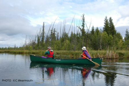
In September, AWA takes a canoe trip to McClelland Lake.
In August, Glasswaters Foundation lends support to AWA’s McClelland Lake campaign with an important grant.
On June 6, the federal Department of Fisheries and Oceans issues a new permit for Imperial Oil’s Kearl Lake oil sands project. The authorization was revoked in March during a legal battle between Imperial and a coalition of environmental groups.
In May, Synenco Energy Inc.’s Directors agree to a takeover offer bid by Total of Synenco, including its McClelland Lake lease and Northern Lights project.
On March 31, the federal Department of Fisheries and Oceans revokes a key water permit for Imperial Oil Ltd.’s proposed $8-billion Kearl oil sands mine.
On March 5, in a landmark decision, Madame Justice Daniele Tremblay-Lamer of Canada’s Federal Court sides with a coalition of environmental groups who asked the court to block the approval of measures proposed by Imperial Oil to manage greenhouse gas emissions with respect to its Kearl Lake oil sands project. Tremblay-Lamer rules that the regulatory panel that approved the Kearl project must “provide a rationale for its conclusion that the proposed mitigation measures will reduce the potentially adverse effects of the project’s greenhouse gas emissions to a level of insignificance.”
2007
On December 21, Synenco Energy Inc. informs AWA that they filed a Supplemental Submission for the Northern Lights Mining and Extraction Project with provincial and federal regulators in mid-December. They forward the submission to AWA in January 2008.
On December 17, Petro-Canada responds to AWA’s Statement of Concern regarding the Fort Hills Oil Sands Project Amendment Application. The main points in the response are as follows:
- Mine operations in the McClelland Lake Wetland Complex (MLWC) “are not expected to begin until 2023.”
- The amendments have reduced the effect of the project on the MLWC.
- The MLWC Sustainability Committee is committed to developing the mitigation plan to maintain the integrity of the unmined portion of the MLWC.
- The Sustainability Committee will decide if an EIA is necessary to develop the mitigation plan and will determine what the Terms of Reference for an EIA will be.
On December 10, AWA meets with Synenco Energy Inc. about their leases near and within McClelland Lake watershed. AWA notes that a Synenco 3rd quarter publication reported that the McClelland Lake Lease winter drilling program of 2006-07 “did not result in any notable discoveries of mineable bitumen resources meeting the company’s physical cut-off parameters.” Synenco states that in the 2007-08 winter drilling program, 20 core holes will be drilled, of which 9 will be on new sites. Synenco promises to inform AWA of the results of this program when publicly available. AWA learns at this meeting that the winter road for access to the Northern Lights project site (northeast of the McClelland watershed) is located within a few kilometers of McClelland Lake’s northern edge. AWA repeats its opposition to disturbance of the McClelland watershed.
On October 18, AWA writes to Petro-Canada acknowledging receipt of information about the Sustainability Committee and reiterating our goal for McClelland Lake watershed: “We would like to work constructively with you to enable your withdrawal from the portion of the Fort Hills lease that is within the McClelland Lake watershed…. Since the current system of selling leases without public consultation and without consideration for ecological sensitivity and uniqueness is seriously flawed, we would support some compensation to Petro-Canada from the government for withdrawing from the watershed.”
On October 1, AWA receives the information about the McClelland Lake Wetland Complex Sustainability Committee from Petro-Canada that was first requested on September 12, 2006.
On September 27, AWA writes to Alberta Premier Ed Stelmach applauding his decision to stop seismic testing on Marie Lake and requesting that the government work with Petro-Canada to withdraw from the original approval the portion of the project that lies within the McClelland Lake watershed.
On September 10, AWA submits a Statement of Concern regarding Petro-Canada’s Fort Hills Oil Sands Project Amendment Application: “In light of the lack of evidence that the ecological integrity of this extraordinary place can be maintained or restored if mining proceeds, we believe that the precautionary principle should be followed and that mining should not be permitted in the McClelland Lake Wetland Complex, and indeed, in the entire watershed…. If this Amendment Application is approved, AWA believes that Petro-Canada must be required to produce a thorough and credible Environmental Impact Assessment of the McClelland Lake Wetland Complex (MLWC), since the portion of the original EIA that related to the MLWC was withdrawn from consideration by the EUB at the hearing in 2002.”
On September 4, AWA writes to Petro-Canada reiterating our request for information regarding the McClelland Lake Wetland Complex Sustainability Committee (first requested September 12, 2006).
On October 11, AWA writes to all Alberta Progressive Conservative leadership candidates stressing the urgent need to protect critical wetlands and watersheds in the province and specifying McClelland Lake watershed as the primary example.
On August 28, AWA chairs a McClelland Lake Strategy Meeting in Edmonton with individuals and organizations concerned about McClelland. Organizations represented are CPAWS, Ducks Unlimited, Sierra Club, Environmental Law Centre, and Canadian Federation of University Women.
On July 25, AWA meets with Synenco Energy Inc. about their leases near and within McClelland Lake watershed. Synenco’s McClelland Lake lease (L0633) covers an entire township that is in the McClelland Lake watershed and overlaps McClelland Lake. Sixty-seven exploratory wells were drilled last winter. Synenco agrees to inform AWA when the results are available. They are not planning to do any drilling in the coming season, as their resources will be going toward the Northern Lights project (just east of the Firebag River). AWA reiterates our position on the McClelland Lake watershed: no development of any kind within the watershed. Although we do have concerns about the Northern Lights project because it is close to McClelland and it crosses the Firebag River, we are most concerned about any plans to develop in the lease L0633. AWA expresses concern about increased access into the McClelland watershed because of Synenco’s proposed road-building.
On July 17, in a letter to AWA about McClelland Lake, SRD Minister Ted Morton states: “Surface mining would only be allowed if the developer maintained the water table, water chemistry and water flow within limits indicated by natural fluctuations, to maintain ecosystem diversity and function of the wetland complex where surface mining is not allowed. Subsequently, the Energy and Utilities Board held a hearing on the Fort Hills Mine and supported this decision with the same constraints to protect the lake and fen.”
On June 14, AWA writes to all Alberta MLAs about the urgent need to amend the boundaries of the Fort Hills Oil Sands Project in order to protect the McClelland Lake Wetland Complex from destruction.
On June 5, AWA writes to the Sierra Legal Defence Fund to request that they consider making McClelland Lake a focus of their oil sands work in Alberta.
On May 29, AWA meets with Petro-Canada to discuss our concerns about McClelland Lake. Petro-Canada states that if the Fort Hills Project is going ahead anyways, AWA should be pleased that a “good operator” is in charge of the development. AWA reiterates our position that McClelland Lake watershed is a critical wetland ecosystem that requires protection from industrial activity and that we will oppose development in the fen and watershed.
On April 23, AWA presents to the Oil Sands Multi-stakeholder Panel in Calgary, reiterating the need “to amend the Fort Hills Project approval to prevent any disturbance within the McClelland Lake watershed.”
On April 2, AWA meets with Synenco Energy Inc., which holds leases just east of the McClelland Lake watershed (the Northern Lights Project) and within the watershed, overlapping the east part of the lake (lease L0633). The Northern Lights Project application was filed in June 2006, with amendments and updates filed in November 2006. Synenco has just finished the second winter of drilling in L0633, next to McClelland Lake, to gather information about the resource on that lease.
On March 29, AWA meets with Judy Smith, Shell Canada, to discuss Shell’s oil sands mining plans in the Athabasca region and to express our concern about the McClelland Lake watershed. Since Shell has bought leases just south of McClelland Lake, AWA requests to be kept informed about their plans for the area.
On March 16, AWA meets with SRD Minister Ted Morton and presents him with information about McClelland Lake, followed up with a letter on March 20 expressing the need for protection of the watershed from oil sands mining.
On February 28, AWA meets with Toronto-based Greenpeace Campaigns Director Yossi Cadan to request support with the campaign to protect the McClelland Lake watershed from oil sands mining.
On February 23, AWA writes to Alberta Energy Minister Mel Knight requesting that Alberta Energy work with Petro-Canada to limit the Fort Hills Project to the oil reserves outside of the McClelland Lake watershed.
On February 20, AWA meets with Petro-Canada to discuss the Fort Hills Project amended plan. They point out the following changes to the plan:
- Most of the plant has been moved from inside to outside the watershed.
- The size of the OPTA has been doubled, from 8 sq km to 16 sq km, and has been moved south slightly so that only part of it is now in the watershed.
- Mining in the wetland complex has been postponed by about 5 years.
Petro-Canada assures AWA that tailings ponds are not very toxic. In response to Petro-Canada’s request for support for the amended plan, AWA reiterates our position, both at the meeting and in a follow-up letter the next day, that absolutely no industrial development should take place in the McClelland Lake watershed and that it should be legally protected.
On February 6, Petro-Canada calls off the sale of five oil sands projects because the bids were unsatisfactory. The company had decided to sell off the five non-core properties to focus on the Fort Hills Oil Sands Project, expected to produce between 100,000 and 170,000 barrels a day.
2006
On December 20, AWA writes to Alberta NDP Environment Critic David Eggen asking for support in the campaign for the legal protection of the entire McClelland Lake watershed.
On December 14, AWA issues an Action Alert urging concerned members and supporters to write to Petro-Canada and the Alberta government to voice opposition to mining within the McClelland Lake watershed.
On November 1, AWA meets with representatives of Alberta Environment, Northern Region to explore possibilities for revisiting the 2002 approvals of the Fort Hills project. AWA is told that there is no precedent for such action, and that only if some major flaw or illegality in the approval process is discovered would it be considered.
In November, AWA meets with representatives of Alberta Environment, Northern Region to explore possibilities for revisiting the 2002 approvals of the Fort Hills project. AE tells us that there is no precedent for such action, and that only if some major flaw or illegality in the approval process is discovered would it be considered.
During the hearing for Imperial Oil’s Kearl tar sands project, aboriginal communities express concern about the impact tar sands development will have on the rivers of northeastern Alberta, particularly the Athabasca. Lawyer Karin Buss, who represents the First Nations, says government has not set limits on the amount of water withdrawn from the river and doesn’t even know the river’s instream flow needs (IFN): how much water flow is needed to maintain the Athabasca’s ecosystem (Calgary Herald, 23 November 2006). (See July 10, 2006.)
On October 26, Petro-Canada advises AWA that construction of the starter dyke for the out-of-pit tailings area (OPTA), which will straddle the McClelland watershed, will likely begin in 2008 or 2009. This involves excavating native soil from outside the McClelland watershed and trucking that soil to the OPTA as construction material for the initial containment dyke. The initial filling of water for the OPTA will likely occur in 2010.
“Petro-Canada is still waiting on detailed costs for the proposed Fort Hills mine and Sturgeon County upgrader, the final pieces of an integrated oilsands strategy.” Petro-Canada predicts initial production of 150-170,000 bbls/day by 2011, increasing to 370,000 with subsequent expansions. The company says it will be another 18 months before the Fort Hills project gets internal approval (Calgary Herald 5 October, 26 October 2006).
On October 20, Petro-Canada informs AWA that the Fort Hills Project amendment plan will be submitted to the Alberta government in mid-December. According to Petro-Canada, mining activities in the fen will not begin before 2030 and the management plan for the sustainability of the unmined portion of the fen will not be due until 2024. Petro-Canada is now removing plants from the fen for pilot projects.
On October 17, AWA writes to Petro-Canada, reiterating AWA’s request for information on the McClelland Lake Wetland Complex Sustainability Committee (originally requested at a meeting with Petro-Canada on September 12, 2006). In the letter, AWA also requests information about Petro-Canada’s removal of rare plants from the McClelland Fen.
On October 13, AWA writes to the Energy and Utilities Board (EUB), the regulatory body that approved the Fort Hills Oil Sands Project in 2002, to ask for clarification about the EUB accepting the withdrawal of the portion of the EIA relating to McClelland Fen. AWA also requests a copy of the Sustainability Plan that the EUB accepted in lieu of the EIA portion. The EUB responds on November 2, 2007, referring us to EUB Decision 2002-089, and on December 5, 2006, referring us to Petro-Canada for more information on the Sustainability Committee.
On September 27, AWA presents to the Oil Sands Multi-stakeholder Panel in Calgary, summarizing the story of McClelland Lake Wetlands Complex and the Fort Hills Oil Sands Project, and stressing “that oil sands development must take place only after identifying and legally protecting irreplaceable watersheds in our boreal forests,” such as McClelland Lake watershed.
InSeptember, aboriginal support for the tar sands boom is diminishing, as the Athabascan Chipewyan and the Mikisew Cree express increasing concern about the withdrawal of water from the Athabasca River. The Athabascan Chipewyan band has formally withdrawn from the Cumulative Environmental Management Association (CEMA), a body comprising industry, government, aboriginal and other representatives, because the band believes that the process is having no influence (Globe and Mail 26 Sept 2006).
AWA makes a presentation (pdf 32KB) in Calgary to the multi-stakeholder Oil Sands Consultations Panel.
AWA meets with Petro-Canada to discuss options for saving the McClelland Lake Wetland Complex from destruction. Petro-Canada says that there must be financial incentives for them to change their mining plans in order to save the Complex.
AWA meets with Synenco to discuss Synenco’s plans for their Lease 0633 in the eastern portion of the McClelland Lake watershed. To date, a few exploratory wells have been drilled but Synenco does not yet know the extent of the tar sands reserve on this lease. They will continue drilling exploratory wells. AWA asks to be kept informed of their plans.
On September 12, AWA meets with Petro-Canada to discuss the Fort Hills Oil Sands Project development and reclamation plans, the activities of the McClelland Lake Wetland Complex Sustainability Committee, and possible options for saving the McClelland Lake watershed. Among the points made by Petro-Canada’s representative at the meeting are the following:
- He has complete confidence that the unmined portion of the fen will remain unaffected and that the mined portion can be reclaimed so that in 200 or 300 years, it will be the same as it was before it was mined.
- The budget for reclamation is unavailable (responding to AWA’s request for same).
- He did not know whether Petro-Canada would be legally responsible if there were unexpected contamination to the unmined portion of the fen, or if the reclamation plan was unsuccessful.
- There are no “practical alternatives” to mining McClelland Fen.
- Petro-Canada would need a financial incentive to withdraw from mining McClelland Fen. Anything less would not satisfy either shareholders or the Board of Directors.
- If Petro-Canada were to consider lease swapping, the lease would have to be adjacent to the current boundaries of the Fort Hills lease, and have equivalent or more reserves.
- If the Sustainability Committee cannot agree that the unmined portion of the fen will not be affected and/or that the mined portion can not be reclaimed, then the project will not go ahead.
- Petro-Canada is already removing plants from the fen (presumably for reclamation purposes).
- AWA requests the following information from Petro-Canada:
- The current development plan, including a map outlining the plan
- The current reclamation plan, if amended from True North’s reclamation plan
- Information on the Sustainability Committee, including Terms of Reference, a list of members, and meeting minutes to date, and ongoing.
On August 1, Pembina Institute and CPAWS announce a new 35-page report calling for “a moratorium on out-of-control oil sands lease sales” and “calling on government to set limits on cumulative industrial impacts” (Media Release, Pembina Institute). Premier Klein’s response: “The Pembina Insitute should keep their noses out of anyone’s business, especially businesses that want to take risks. To have a long-range plan would be an interventionist kind of policy.… The last thing we want to be is an interventionist government” (CBC News, August 3).
AWA’s Joyce Hildebrand spends several days in Fort McMurray. Petro-Canada, the operator of Fort Hills tar sands project, takes her on a 3-hour tour of their MacKay River SAGD project. She also meets with Chief Jim Boucher of Fort McKay First Nation to discuss the Fort Hills project.
On July 28, two AWA staff are accompanied by Dr. Ian Urquhart and Dr. Diana Horton on a 2-hour flight from Fort McMurray over the McClelland watershed and the tar sands mines. They observe considerable fragmentation of the watershed, including clearcuts, seismic lines, wellpads, a pipeline corridor, and evidence of ATV use.
On July 23, AWA writes to Petro-Canada reiterating our concern about the Fort Hills Oil Sands Project and asking to be kept informed about the McClelland Lake Wetland Complex Sustainability Committee’s activities.
On July 20, the Supreme Court of Canada refuses to hear an appeal of the Federal Court of Appeal’s ruling in Prairie Acid Rain Coalition et al. v. Canada (Fisheries and Oceans). AWA issues a news release on the Court’s decision: “At issue in the case is the interpretation by the federal Department of Fisheries and Oceans (DFO) of what aspects of the Fort Hills project required a federal environmental assessment. The Fort Hills open pit mine and bitumen processing facility will sprawl across roughly 180 square kilometres (70 square miles) and will disrupt and destroy fish habitat, valuable migratory bird habitat and the traditional lands of the area’s aboriginal peoples. Rather than subject the whole project to an environmental assessment, DFO officials used their discretion under the Act to confine their attention to the destruction of fish habitat in Fort Creek – a very small part of the whole project.”
The Supreme Court decision reflects the federal government’s cynical approach to environmental assessment. MiningWatch Canada reports that “a recent spate of astonishing decisions on a range of mining projects has made it clear that the Federal government has decided that environmental assessment (EA) is a pro forma exercise that will not be allowed to do so much as inconvenience mining companies” (Newsletter No. 19, Summer 2005).
On July 10, Alberta Environment and Fisheries and Oceans Canada completes a draft Water Management Framework: Instream Flow Needs and Water Management System for the Lower Athabasca River:
- “AENV and DFO are recommending a precautionary approach, implemented in phases with ongoing review, so that monitoring, which improves the understanding of the effects of water withdrawals, can be incorporated in a water management system that will protect the ecological integrity of the aquatic ecosystem of the lower Athabasca River” (p. 4).
- “While current oilsands water use has generally been below the most stringent limits identified within the Phase 1 Framework, current licences have allowed for maximum amounts that could cumulatively exceed them” (p. 5).
- “The Phase 1 Water Management Framework is being released to guide regulatory decision-making in upcoming applications” (p. 5).
On June 30, Jim Boucher, Chief of the Fort McKay First Nation, and several provincial and federal politicians sign a ceremonial document acknowledging the Treaty Land Entitlement (TLE) Settlement Agreement. Finalized in 2004, the TLE Agreement will see the transfer of 9,308 ha of land back to Fort McKay. Approximately 3,318 ha of these lands hold very significant tar sands deposits, which will provide Fort McKay with opportunities to pursue economic self-sufficiency. 4,047 ha have been set aside to preserve traditional practices. The TLE Agreement also provides Fort McKay with $41.5 million over a 3-year period in compensation for loss of land use. According to a Treaty Days News Release (http://www.fortmckay.com/), “Fort McKay is also a leader in environmental protection and industry/First Nation relations.”
Chief Boucher says, “We are now able to play a significant role in the oil sands exploration and development while ensuring that there are adequate reserve lands for our traditional way of life” (Red River Current August 2006).
In June, Eos Research and Consulting completes a project for Petro-Canada on water issues affecting the company’s upstream operations in western North America. The report concludes that “based on current patterns of use, many drainages already have insufficient supply to meet needs and in many other drainages there may be insufficient water to meet expected future needs.” The report, which has not been released to the public, provides Petro-Canada with recommendations for management approaches to address identified water-related risks.
Synenco Energy Inc. files the Northern Lights oil sands project, located just east of the McClelland Lake watershed, across the Firebag River.
On May 17, the Alberta government announces that it will accept all nine recommendations made by the Oil Sands Consultation Group. In particular, it commits to establishing a multi-stakeholder committee accountable for the overall consultation process, and a panel to collect public input. The panel will hold public meetings and information sessions, especially in the main tar sands areas of Fort McMurray-Wood Buffalo, Peace River, Athabasca and Cold Lake. Members of both the committee and the panel will be appointed by government to ensure representation from the public, industry, environmental groups, First Nations, and other stakeholders. Public consultations are expected to start in September 2006, with the process to be completed by June 2007.
On April 19, after more than a decade of negotiation, Shell Canada and Fort McKay First Nation announce that they have reached an agreement to jointly develop tar sands leases. This is the first time First Nation land has been considered for tar sands development. Shell obtained the rights to Lease 90 before the land was awarded to Fort McKay as part of a settlement completed in 2003. Under terms of the deal announced today, Fort McKay First Nation has the option to buy Lease 90 from Shell in exchange for Shell’s right to right to lease other adjacent band lands for potential incorporation into the Athabasca Oil Sands Project (AOSP), of which Shell owns 60%. The possibilities under the Shell-Fort McKay agreement range from FortMcKay providing mining services on Lease 90 to owning it outright and managing the tar sands process. Construction could begin as early as 2009. Jim Boucher says that the anti-fur lobby of the 1980s “pretty well killed off the economic viability of our communties.” He considers tar sands development a logical alternative: “For us, we had to find different ways of finding economic opportunities for our people.” Since 1986, the Fort McKay Group of Companies, owned and operated by the Fort McKay First Nation, has provided oilfield services with annual revenues at approximately $100 million. (Calgary Herald, 20 April 2006)
On March 31, the Oil Sands Consultation Group delivers its final report to the Alberta government setting out plans for consulting on policy principles for Alberta’s mineable tar sands area. The report makes nine recommendations, all of which are accepted by the government. The key recommendations are the following:
- A hybrid multi-stakeholder and panel model and process should be developed and used;
- The scope of the consultation should include economic, environmental and social issues considered in an integrated manner;
- Consultation on oil sands development should be undertaken as a subject matter, not on a defined geographic area;
- The consultation process should include assessment of possible linkages to other policies or processes already in place, governmental or otherwise;
- The consultation process should be structured so as not to prejudice the consultation rights of First Nations; and
- Consultation should take place in the three oil sands areas – Peace River, Cold Lake and Athabasca – as well as Edmonton and Calgary.
On March 6, AWA’s Ian Urquhart writes to Synenco Energy Inc. to express concern about Synenco’s purchase of lease L0633 in the eastern McClelland Lake watershed: “Future development of this lease … would be the final nail in the coffin of the ecological integrity of the McClelland Lake wetland complex.”
In February, UTS Energy reports that a tar sands upgrader to process bitumen from the Fort Hills mine will be built in Sturgeon County, about 40 km northeast of Edmonton. (Business Edge, February 2, 2006)
On January 27, the Federal Court of Appeal releases a decision in favour of Fort Hills Energy Corporation stating that the Minister of Fisheries and Oceans correctly scoped the Fort Hills project. The Court found that due to the fact the Alberta provincial authorities conducted an environmental assessment, an additional assessment at the federal level would have been inefficient. This matter was on appeal from the federal trial decision, where on Sept. 18, 2004, the trial judge also found in favour of the Respondents. The Applicants may appeal further by seeking the leave of the Supreme Court of Canada.
On January 16, AWA writes to Environment Minister Guy Boutilier explaining our concern about the mining of McClelland Lake fen and explaining AWA’s decision not to participate on the McClelland Lake Wetland Complex Sustainability Committee. Alberta Environment Deputy Minister Peter Watson responds on February 14, 2006.
Dr. Ian Urquhart meets with representatives of Synenco to inform them of AWA’s proposal to protect the entire area as a provincial park, with the two patterned fens protected as ecological reserves. Synenco is the managing partner for the Northern Lights tar sands project northeast of the Complex.
2005
On December 12, Sierra Legal Defence Fund appears before the Federal Court of Appeal to challenge a Federal Court decision (Sept. 18, 2004) allowing the Fort Hills project to go ahead without an adequate environmental assessment. Sierra Legal argues that theCanadian Environmental Assessment Act requires the entire proposed project, rather than just one small creek, to undergo a federal environmental assessment.
The Alberta government announces that it will cancel the initial feedback sessions on the draft MOSS (Mineable Oil Sands Strategy) and will instead create the Oil Sands Consultation Group, mandated to provide revised plans for a consultation process for tar sands development.
In November, Petro-Canada announces that the McClelland Lake Wetland Complex Sustainability Committee is being established “to assist with the development of an operational plan which will maintain the protected portion of the wetland.” The Committee will begin to operate in the coming months. According to EUB Decision 2002-089, the Committee will “oversee the collection of baseline monitoring data, establish the natural variability of the wetland, establish criteria to protect the biotic diversity and function of the no-surface-access zone, critically evaluate proposed mitigation plans in relation to the protection criteria, and evaluate postconstruction monitoring data and adaptive management” (sec. 10.3).
The federal government passes the First Nations Commercial and Industrial Development Act to foster industrial development on reserve land. Jim Boucher, Chief of Fort McKay First Nation, is a big proponent of the legislation. (Calgary Herald, April 20, 2006)
On October 28, AWA writes to Environment Minister Guy Boutilier asking for protection of McClelland Lake Wetland Complex and expressing disapproval of the 2002 IRP amendment “with very poor public consultation, to allow oil sands mining in this region.” The Minister responds on Nov. 17 with the usual platitudes: “Alberta Environment shares your desire to preserve the beauty and integrity of the McClelland Lake Wetland Complex. … [and] recognizes the importance of sustaining the undisturbed portion of the wetland complex.” What the Minister does not recognize is that disturbing any portion of the complex will destroy the ecological integrity of the entire area. According to scientist Richard Thomas, “The claims by True North Energy and SRD at the 2002 EUB Hearings that mining half [of the] MLWC would not impair the ecological function of the Complex or McClelland Fen are utterly devoid of credibility.”
On October 26, The government of Alberta releases the Mineable Oil Sands Strategy (MOSS), replacing the Fort McMurray-Athabasca Oil Sands Subregional Integrated Resource Plan (approved by Cabinet in 1996 and updated in 2002) and proposing a fundamental shift in environmental policy. While previous policy at least gave lip service to preserving ecological integrity, MOSS gives priority to tar sands extraction over environmental protection: “Within the coordinated development zone, oil sands mining will have the highest priority.”
In September, Synenco Energy Inc. purchases oil sands lease L0633 in the eastern portion of the McClelland Lake watershed, overlapping McClelland Lake.
In a news release, AWA denounces Alberta’s Mineable Oil Sands Strategy (MOSS) as evidence that the provincial government has no intention of protecting valuable wetlands such as the McClelland Lake Wetland Complex, despite its declarations to the contrary. Not only does MOSS commit to give tar sands “the highest priority” over nearly 3,000 km2; it also prevents the possibility that the Alberta Water Council will be able to fulfill its goal of developing “a comprehensive wetland policy that applies to all areas of the province.”
Petro-Canada and UTS acquire a third partner in the Fort Hills project, Teck-Cominco, with Petro-Canada intending to remain as project operator with 55% stake.
Synenco Energy purchases tar sands lease L0633, which lies in the eastern portion of the McClelland Lake watershed and overlaps the lake. “Future development of this lease … would be the final nail in the coffin of the ecological integrity of the McClelland Lake Wetland Complex” (letter from AWA to Synenco, March 6, 2006).
On May 20, Petro-Canada writes to AWA requesting input on the establishment of the McClelland Lake Wetland Complex Sustainability Committee. AWA responds on June 10, 2005: “We believe mining compromises the ecological integrity of the entire site. Destroying half of this fen and trying to save the other half is not an acceptable solution to us…. In the list of purposes for the Sustainability Committee you include : ‘establish criteria to protect, to the extent possible, the biotic diversity and function of the no-surface-access zone.’ It is clear from this that you are essentially conducting an experiment on this unique site…. We don’t believe this world-class site should be used for experiments.”
Petro-Canada invites input from AWA on the establishment of a MLWC Sustainability Committee, the purpose of which would be to help mitigate environmental effects of mining in the complex. AWA responds with a letter (June 10) reiterating our concern about and opposition to the development of the McClelland fen, and our disagreement with the government’s changes to the IRP: “We don’t believe that this world class site should be used for experiments.” AWA therefore gives no input to the Committee, since participating in any way would be giving support to destruction of the fen.
In April, AWA writes to Alberta Premier Ralph Klein expressing concern about the potential destruction of the McClelland Lake Wetland Complex and requesting the Alberta government consider alternatives to mining the McClelland Lake fen.
On April 12, UTS announces that construction of an experimental plant to demonstrate the Bitmin extraction process is anticipated this summer, subject to regulatory approval. The plant will produce approximately 3,500 bbl/day from tar sands mined on the Fort Hills lease.
On April 6, AWA meets with Petro-Canada to discuss the Fort Hills project.
AWA writes to Premier Klein urging the government to consider alternatives, such as lease trading, to the mining of McClelland fen. Copies are sent to a number of ministers and MLAs and to Ken Hall of Petro-Canada. SRD Minister David Coutts responds on June 7, saying that the IRP was amended following “thorough review” and now “[allows] for recovery of oil sand reserves within the McClelland Lake wetland complex and [specifies] that any mining activity shall maintain the water table and chemistry, to preserve the ecology of the complex.”
In March, Petro-Canada acquires 60% ownership of the Fort Hills tar sands project and plans an initial mining development of 100,000 bbl/day and corresponding upgrader. UTS retains 40% ownership. AWA puts out a news release stressing the urgency of protecting McClelland Lake Wetland Complex in light of this new development.
In February, UTS Energy Corp., the new owner of the Fort Hills tar sands project, move ahead with engineering and regulatory work. The company submits an application to the EUB for construction of a $40 million “demonstration plant” that will carry out field trials of Bitmin, a new bitumen extraction process. Construction is scheduled for April to September 2005, and operations are scheduled for October 2005 to March 2006. The plant is to be decommissioned in April 2006. A small mining operation is also planned to provide feed to the plant from part of the lease. Mine construction is to begin in July 2005.
UTS says that a new corporate partner may be recruited by mid-2005. UTS is working on a revised $2 billion plan to develop 188 sq km of bitumen leases in the area.
2004
In September, in a Federal Court decision, the Court releases a decision in favour of Petro-Canada, upholding the Department of Fisheries and Ocean’s decision to limit the environmental assessment of the Fort Hills project to one small creek in the entire project area.
On July 9, UTS completes acquisition of TrueNorth Energy (for $ 125 million) and creates Fort Hills Energy. UTS holds contiguous Leases 5, 8, 52 (and 14, west of Athabasca River). The Fort Hills project received regulatory approval in October 2002 to produce up to 235,000 bbl/day. The project is in the initial stages of being re-scoped with a proposed initial phase of production totalling 50,000 bbl/day in 2009.
In May, on behalf of the Pembina Institute, Prairie Acid Rain Coalition, and Toxics Watch, Sierra Legal Defence Fund lawyers go to court to challenge the Department of Fisheries and Oceans’ 2002 decision to limit the Fort Hills tar sands project’s federal environmental assessment to an examination of one small creek within the project area instead of investigating the impacts of the 10,600-ha project as a whole. “DFO has backed right out of managing the impacts of this project and turned CEAA into a mere formality en route to project approval,” says SLDF lawyer Tim Howard.
2003
In January, True North announces that it will not proceed with the McClelland Lake fen development.
2002
On October 22, the Alberta Energy and Utilities Board approves TrueNorth Energy’s proposed Fort Hills project – which involves excavating 49% of the McClelland Lake Wetland Complex and 45% of McClelland Lake fen. The Board “is prepared to allow the project to proceed subject to their approval of a detailed mitigation plan.… [T]he onus to establish a workable and credible plan will be on True North” (EUB Decision 2002-089, sec. 10.3).
Among the recommendations of the EUB’s Decision 2002-089 approving True North’s application to mine in McClelland fen is the following: “The Board recommends that Alberta direct True North to convene a committee of stakeholders and regulators, as proposed in the MLWC Sustainability Plan, to oversee the collection of baseline monitoring data, establish the natural variability of the wetland, establish criteria to protect the biotic diversity and function of the no-surface-access zone, critically evaluate proposed mitigation plans in relation to the protection criteria, and evaluate postconstruction monitoring data and adaptive management.”
The results of TrueNorth’s EIA indicate that serious changes to the wetland were likely to occur as a result of mining. TrueNorth withdraws the portion of the EIA describing the project’s impacts to the Complex and is allowed by the Board to replace it with the so-called Sustainability Plan. “TrueNorth was confident that the sustainability plan … could be effective in maintaining ecological diversity and function, as required by the amended IRP” (EUB Decision 2002-089, section 10.1).
The EUB Decision mentions that to demonstrate their commitment to wetland research, TrueNorth recommended and received placement of a temporary protective notation on the Thickwood Hills wetland. They also committed to a five-year wetland research program led by the University of Alberta. What EUB Decision 2002-089 fails to mention is that this $1 million research grant is given to the same scholars who wrote the Halsey et al. report for TrueNorth indicating that McClelland Lake Wetland Complex is not “unique.” The IRP amendment that allowed mining in the Complex was to a great extent based on that report, as was the EUB approval of the Fort Hills project.
In September, the Department of Fisheries and Oceans makes a submission to the EUB regarding TrueNorth’s application. Their comments on McClelland Lake include the following:
- “A portion of the fen draining into McClelland Lake system from the southwest will be directly altered under the mine development plan.… McClelland Lake, its outlet creek and the Firebag River component, will have their drainage regimes altered as a result of mine dewatering and drainage. During dewatering and mining activities (2010 – 2025) flows to McClelland Lake, its outlet creek and the drainage to the Firebag River will be increased above baseline conditions. From 2026 – 2040, closed circuit operations without dewatering discharges to McClelland Lake will reduce lake inflows.”
- Regarding the sinkhole lakes, the submission says, “There are eight lakes upslope of McClelland Lake. Some of these are closely associated with the McClelland Lake Fen. All will be affected, either directly by mining or indirectly through changes in the water balance. Six of the eight lakes were sampled for fish. Brook stickleback were found to occur in two of the six lakes sampled.”
Environment Canada makes a submission to the EUB about TrueNorth’s mining application. EC’s document is filled with concerns about the potential impacts of the project, outlining the many uncertainties that still exist. Some excerpts follow:
- “The proposed mine closure and reclamation plan includes a number of end-pit lakes which propose to discharge into the Athabasca River and McClelland Lake. … [U]ncertainty still exists about the efficacy of the end-pit lakes to remove toxicants which may be moving down the drainage systems.… Predicting cumulative effects on the aforementioned major receiving waters is still surrounded by considerable uncertainty.”
- “McClelland Lake is a shallow water body vulnerable to sediment re-working by ice and wind action. Any PAH’s or other adsorbed materials in sediments contributed by the mine into McClelland lake could potentially be resuspended and made available to the food chain.”
- “TrueNorth predicts changes in water quality and potential exceedences of a number of water quality parameter guidelines … as a result of aquifer dewatering and mining releases. Even though the EIA report predicts that the effects of these water quality changes should not be toxic and should not have a major effect upon the lake ecosystem, there is still uncertainty about the impacts to McClelland Lake.”
- There is “uncertainty about the actual effect of surficial and basal aquifer dewatering on groundwater levels and chemistry in the fen, including the lack of knowledge about the permeability of surface layers underneath the fen.”
- “Salinity (TDS) contributed to the fen by mining activities may strongly affect fen vegetation … and poses a serious threat to the integrity of the fen.”
- “The Regional Study Area (RSA) region has a complex pattern of forest growth and natural regeneration intermixed with wetland complexes and patterned fens which makes for a varied and dynamic environment for wildlife in the area. The TrueNorth Mine alone represents a development that will directly impact over 10,600 hectares (or 41 sq miles) of land. Other proposed and existing mines will also impact similar expanses of land. Environment Canada is concerned that the loss and changes of habitat associated with oil sands development, coupled with pipelines, utility corridors, roadways and existing forest harvest strategies, could have a measurable impact on the levels and variety of wildlife, ecosystems and ecological processes that exist there.”
- “The maximum level of habitat disturbance within the RSA that can still sustain healthy resident and migratory bird populations into the longer term is currently unknown.”
- “From an Environment Canada perspective the McClelland Lake Wetland Complex is an excellent example of a patterned fen, that supports migratory birds, COSEWIC listed species, rare plant species, high biodiversity, and has an added feature of being associated with a lake. Environment Canada views the McClelland Wetland Complex as an ecologically important landscape feature that encompasses less than 0.5 percent of the broader Oilsands Regional Study Area.”
- “Environment Canada is concerned that the limited information reviewed does not provide sufficient basis to adequately assess whether the proposed True North Fort Hills Project, in combination with other oil sands projects in the region, is likely to result in fish tainting of the Athabasca River.”
On August 24, the Edmonton Journal reports claims by the president of Fort McMurray’s medical staff association that “True North Energy tried to cut a deal to silence local doctors” before the EUB hearing into the Fort Hills Oil Sands Project. True North initially offered the health region $50,000, no strings attached, for medical research. Subsequently, an offer of another $100,000 was made, conditional on the medical association writing a letter to the EUB removing its objection to the project. The letter added: “Should the EUB determine that a hearing is unnecessary, True North will contribute a further $100,000 to support the study.”
From July 2 to July 10, a hearing is held for TrueNorth’s Fort Hills application. TrueNorth withdraws the portion of its EIA describing the project’s impacts to the McClelland Lake Wetland Complex and asks the Board to consider the McClelland Lake Wetland Complex Sustainability Plan, developed in consultation with the Fort McKay Industry Relations Committee. The Plan calls for the creation of a committee of regulators and stakeholders to develop a management strategy to sustain the unmined eastern portion of the wetland.
On June 29, in its plan for mitigating effects of the proposed Fort Hills mine development, Golder Associates confidently asserts the following: By about 2029, “the effects [of mine development] will comprise a reduction in McClelland Lake drainage area by about 60 km2. … These effects on the fen area will be eliminated when the mine area is reclaimed and drainage to receiving waters is restored by about 2040.”
In his contribution to the EUB hearing for TrueNorth’s application on July 9, 2002, Dr. Richard Thomas states that if the application is approved, the area “would cease to be a naturally functioning wetland complex.” He adds that “reclamation is not ecological restoration. We will never return to that fantastically complex fen.” He also notes that TrueNorth’s Mr. Ross Eccles noted the week before “that we are not sure of what the final reclaimed landscape is going to look like” and that we are faced with “the greatest uncertainties with regard to reclamation concern [sic] wetlands.” Thomas confirms that “in reality, there has been very little progress with wetland reclamation.”
On June 14, under pressure from cabinet (on behalf of TrueNorth Energy), Alberta Sustainable Development amends the Subregional IRP to allow TNE to mine within the McClelland Lake Wetland Complex (or, in the government’s words, “to reflect a balanced approach” [Government of Alberta Information Bulletin]). The IRP amendments impose a requirement to protect the unmined portion of the Wetland Complex. References to the uniqueness and unusually large size of the McClelland Lake fen are removed from the IRP.
The entire amendment process takes four months, as compared to the four-year process that resulted in the original IRP in 1996. Only two open houses are held, and only in northern communities: Fort McMurray and Fort Chipewyan. In fast-tracking the amendment, the government violates its own Plan Amendment Guidelines set up in 1991, which specify a six-week public review process. The current process allowed less than a month for public input.
Over the 25-year history of IRPs, these plans have had minor changes and in some cases an entire plan has been updated (e.g., the Eastern Slopes Policy), but this is the first case where an IRP has been significantly amended as a result of a proponent’s request to overturn policy.
The core public element of the review process involves a two-page survey, with extremely limited time to respond (April 4-30). The survey simplistically positions the issue as protect the wetlands OR create economic growth and employment. Furthermore, during the two government-held open houses, both on short notice and both held in the area, TrueNorth Energy was allowed to display their proposal, an inappropriate gesture given that the government claimed that the project approval process was separate from the IRP amendment process.
Despite being stacked in favour of amending the IRP, the “Executive Summary of Public Responses” for the amendment review indicate that most respondents have serious concerns about changing the IRP to open ecologically sensitive areas to tar sands mining.
In April, True North Energy, the Fort Hills Oil Sands Project proponent, grants $1 million to the University of Alberta to fund wetlands research on two patterned fens, one of which is the McClelland Lake fen. The research will be undertaken by two biological scientists, Dr. Kevin Devito and Linda Halsey. Six months ago, on October 29, 2001, a paper co-written by four scientists including Devito and Halsey concluded that “the patterned fen element of the McClelland Lake Wetland Complex does not represent the “best” patterned fen in the province but is a representative example of this landform type” (Supporting Information For Alberta Government Review of Guidelines in Fort McMurray-Athabasca Oil Sands Sub-regional Integrated Resource Plan).
In response to TrueNorth’s application to the Alberta government for a relaxation of the guidelines in the 1996 Fort McMurray-Athabasca Oil Sands Subregional Integrated Resource Plan, SRD releases public notice that they will review the guidelines. TrueNorth wants to mine a portion of the fen and says that the oil resource underlying the fen is large, previously unknown, and integral to the economic success of its Fort Hills project.
AWA releases a news release (April 4) seeking support for protection of the area. On April 8, a joint news release is issued by Pembina Institute, AWA, and Toxics Watch: “The Government advertised their first public information session four working days before it occurred with a single ad that did not include the time, date, or location of the event.” While the original IRP was the result of four years of considerable review and public input, the current amendment process promises to be rushed.
On April 16, University of Alberta announces the $1 million research grant from TrueNorth Energy for the Northeastern Alberta Wetland Research Initiative. The research will be led by two of the authors of the 2001 Halsey et al. study that was commissioned by True North and that concluded that the McClelland Lake fen was “representative” rather than “unique.”
On February 28, AWA writes to SRD Minister Mike Cardinal expressing concern about the Subregional Integrated Resource Plan Guideline review triggered by True North Energy’s Fort Hills Oil Sands Project proposal.
2001
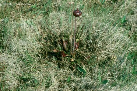
A paper entitled Thickwood Hills Patterned Fen and the McClelland Lake Wetland Complex (Doubt and Belland 2001) reports on a number of rare plant species found in the McClelland complex but not in Thickwood Hills fen. (Thickwood Hills patterned fen is larger than only 36% of patterned fens in Alberta while McClelland Lake patterned fen is larger than 91%.)
A report for TrueNorth Energy entitled Landscape and Landform Variation in Patterned Fens within Alberta (Halsey et al., pdf 509KB) provides an analysis of factors related to uniqueness, size, and degree of development. The report claims that McClelland Lake wetland is more “representative” than “unique,” contradicting the findings of Westworth and Associates (1990) and of a previous conclusion by one of the authors of the report (Nicholson 1991). The Halsey at al. study is used by the Alberta government to support changing the IRP to allow development in the MLWC.
In his contribution to the EUB hearing in July 2002 on TrueNorth’s Fort Hills application, scientist Dr. Richard Thomas comments on the Halsey report. Based on other, more complete analyses and his critique of the Halsey report, Thomas refutes the claim by True North and by Halsey that the McClelland Lake Wetland Complex is representative rather than unique. He notes that “[Halsey et al.’s] conclusion is based wholly on what we can call ‘landform morphometrics’ and comparisons of the same. … [T]heirs was a nonholistic analysis. For example, it did not consider biodiversity, it did not consider the presence of rare species, and it did not consider any of the other values that I have talked about with regard to the wetland complex.”
At the same hearing, peatland expert Dr. Diana Horton pointed out that the selection of study sites for the Halsey et al. study is fundamentally flawed (pdf 112KB). First, two non-patterned fens were included in a study that purports to examine characteristics of patterned fens. Second, peatlands were selected on the basis of ease of access – if they were close to a road, for example – introducing bias into the analyses. Third, one of the most striking features of McClelland Lake fen is that it is associated with a large lake, yet peatlands associated with large lakes were not targeted in this study.
1999
In February, the Special Places Provincial Coordinating Committee, Boreal Forest Subcommittee recommends that McClelland Lake and fen complex be reserved under some form or protective notation (BFS Minutes, Feb. 16/17, 1999).
1998
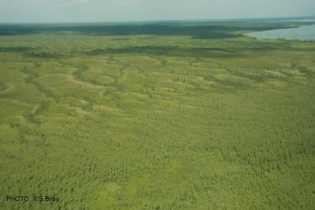
Alberta Environmental Protection’s Boreal Forest Natural Region of Alberta report states that the 164 km² MLWC candidate protected area is worthy of protection: “The importance of this site derives from the combination of diverse biophysical features it contains and ecological functions it performs. Some superb reticulate and ribbed fens occur in the SW part of this [patterned fen]. McClelland Lake is an excellent prospect for protection worthy of a strenuous protection effort. Any protected area established here will need to be ‘buffered’ from oil sands developments to its south and will require restoration to reverse the adverse ecological impacts resulting from human activities in the region.”
1997
Koch Industries purchases Fort Hills Leases (5 and 52) from bankrupt Solv-Ex. Koch and UTS form True North Energy (TNE).
1996
On May 7, the highly contentious Ft. McMurray-Athabasca Oil Sands Subregional Integrated Resource Plan (IRP) – which took 4 years to thrash out – is finally approved by cabinet. This plan places McClelland Lake Wetland Complex off-limits to tar sands mining.
The IRP includes the following statements (pp. 29-30):
- “In the Clearwater River valleys, McClelland Lake wetland and the McKay tributary adjacent to Fort McKay, oil sands development using surface-mining techniques is not permitted. Within the remaining ‘tributaries’ of the RMA [Resource Management Area], surface mining will be considered only where the proponent clearly demonstrates that efforts are being made toward applying mitigative measures and reclamation procedures that reflect the higher sensitivity of these areas.”
- “In situ oil sands development will not be permitted within McClelland Lake or the adjacent wetland fen”
- “Exploration programs in the McClelland Lake wetland must not interfere with the contours of the landscape in a manner that alters the waterflow.”
1995
In November, a 435-km² area including McClelland Lake Wetland Complex is nominated for protection under the auspices of the Alberta government’s Special Places 2000 programme, by a coalition of 11 conservation/recreation/wildlife user groups. Protection for MLWC is subsequently thwarted due to political pressure and intense lobbying by Alberta Energy.
Syncrude Canada announces plans for its new Aurora mine on leases to the immediate south of the Fort Hills. Solv-Ex Industries want to develop a new plant at the doorstep of the Fort Hills, near the Provincial Historic Site of Bitumount. Solv-Ex obtains Lease 52, which covers the southwest half of the proposed area, including one of the patterned fens. Al-Pac has plans to log in townships south and northeast of McClelland Lake, starting in 1997.
The Northeast Wild Alberta Coalition (NEWAC, representing numerous local environmental, recreational and wildlife user groups) researches background information and looks for protective designations that provide the highest level of protection but are consistent with existing land use patterns. NEWAC suggests Ecological Reserve and Provincial Park status as the most appropriate protection for the McClelland Lake area, as it “would prevent it from being fragmented by seismic lines, logged, mined, or drilled, and would allow traditional native uses, trapping, and recreational uses to continue within a conservation-oriented context.” (1995 brochure)
1994 – 1995
Over the winter, lands inside the Proposed Protected Area boundaries, south of McClelland Lake, are logged. Applications for new harvesting areas north of the Lake, and the related harvest planning, have begun.
1994
In November, AWA invites the Northeast Wild Alberta Coalition (NEWAC, representing numerous local environmental, recreational and wildlife user groups) to discuss potential new protected areas in northeast Alberta. The Fort Hills is given top priority as an area in need of protection, under threat, and having both wildland and recreational potential.
In May, the draft Fort McMurray-Athabasca Oil Sands Subregional Integrated Resource Plan contains provisions to “protect the natural landscape” of the area.
The Northeast Region Regional Integrated Resource Plan: Draft Plan
The northeast region is divided into 4 resource management areas (RMAs): northern boreal, boreal, transition and settled. McClelland Lake falls within the Boreal RMA.
Regional Objectives
- To promote conservation and orderly development of public land and resources.
- To ensure protection and maintenance of environmental quality in the management of public land resources.
- To maintain healthy ecosystems.
- To maintain ecological diversity.
- To protect people, their homes and businesses and natural resources from wildfire.
- To protect the forest and range resources form damage by insects and disease.
- To reclaim lands disturbed as a result of development to an equivalent land capability.
- To maintain public access to public land and resources.
- To ensure the best overall allocation and use of resources on public land for the social and economic benefit of the people of Alberta.
The draft plan states that “resource management of Riparian Areas will focus on maintenance of water quality, habitat retention and recreation.… Future subregional and local integrated resource plans will use Riparian Areas as fundamental resource management units.” Alberta Environmental Protection is to “coordinate implementation of a policy for wetland management.… Education about wetland functions, values and management will be increased and stewardship promoted. Drainage of wetlands will be guided by the wetland management policy and by regional wetland objectives, and may be permitted under licence.”
Solv-Ex Corp. establishes joint venture with United Tri-Star Resources Ltd. (UTS) and proposes to develop an experimental tar sands plant on Lease 5. Solv-Ex subsequently (1995) acquires Lease 52.
1991
Barbara Nicholson submits a report on Alberta wetlands and peatlands to the Natural Areas Program of Energy and Natural Resources, Alberta. She says: “The two fens surrounding McClelland Lake, one to the southwest and the other to the east of the lake have the most prominent string and flark pattern in the province. The vegetation in these fens is likely to be sensitive to changes in climate, hydrological flows and damage, as the water table in these fens is high.” Nicholson goes on to give the McClelland fen complex “high priority for preservation” (from “A selection of 54 peatlands chosen as a first approach to the preservation of important wetlands and peatlands in the province of Alberta” 1991). Nicholson will later reverse this assessment in a report submitted on behalf of TrueNorth Energy to the EUB hearing on TrueNorth’s application to mine in the fen (see 2001).
1990
Significant Natural Features of the Eastern Boreal Forest Region of Alberta by D.A. Westworth & Associates, Dec. 1990, identifies several environmentally significant natural features in Alberta’s eastern boreal forest. McClelland fen is the only patterned fen mentioned and is identified as provincially significant, having rare and significant plant species and an important waterfowl nesting area. The report describes McClelland Lake wetland as “unique,” “one of the largest in the province,” and “considered to be the best developed in the Boreal forest.” The report also describes McClelland Lake as provincially significant staging area for waterfowl.
1985
The Parks Service places a land reservation on part of the Fort Hills for future recreational potential.
1980
The Bitumount area of the Fort Hills is identified as a first priority for provincial park development. The Parks Division makes applications to the Public Lands Division for reservations and notations to cover about 78 km2 of the Fort Hills-Bitumount area, a park study area within which a future park boundary may be established.
From: An Outdoor Recreation Plan for the Northeast Alberta Region, Alberta Recreation and Parks: “The area contains a wooded upland with a thickly wooded periphery. Aligned sink holes and parallel ridges of unknown origin, a dissected kame and McClelland Lake are significant natural resources.… McClelland Lake adjacent to the area is a shallow eutrophic lake with a large wetland area on its west side. Although much used by waterfowl this area will likely be considerable impacted from the construction and operation of a proposed new airport nearby.”
1978
Syncrude plant commences operation.
1967
First tar sands plant in northeastern Alberta comes on stream.
About 6000 to 4000 BC
The development of McClelland Lake’s extensive peatlands begins.


 Oil sands operation (Diana Horton)


