June 22, 2024
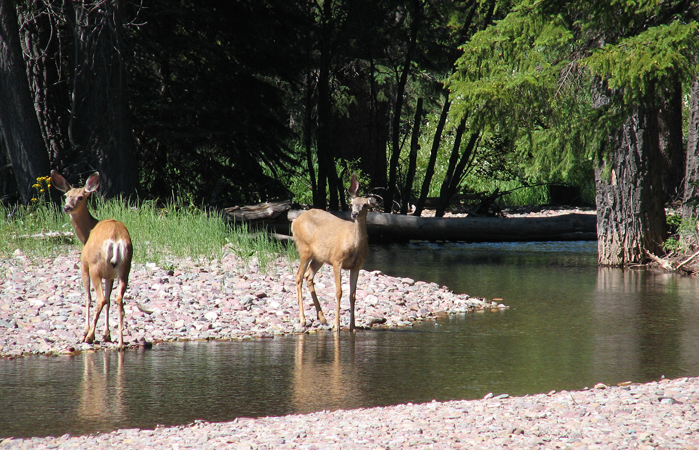
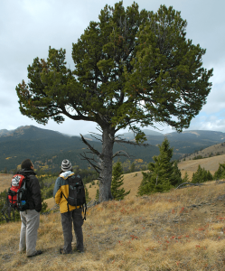
Highwood Reflections Adventure – June 22, 2024
Text by Devon Earl Photos by Devon Earl and Carolyn Fisher The group headed out…


Boasting some of Alberta’s most iconic landscapes, the Rocky Mountains Natural Region is a critical source of drinking water for Canada’s prairies and home to wildlife such as grizzly bears, native trout, and woodland caribou.
Mount Temple. PHOTO © N. DOUGLAS
White Goat Wilderness. PHOTO © J. MILLEN
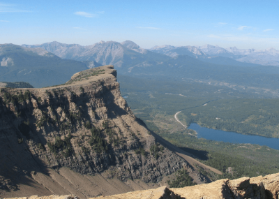
Table Mountain, Castle. PHOTO © S. NICHOLS
AWA believes that the Rocky Mountains must be protected in order to sustain biological diversity and viable wildlife populations, provide clean drinking water across Canada, and promote long-term economic and recreational opportunities
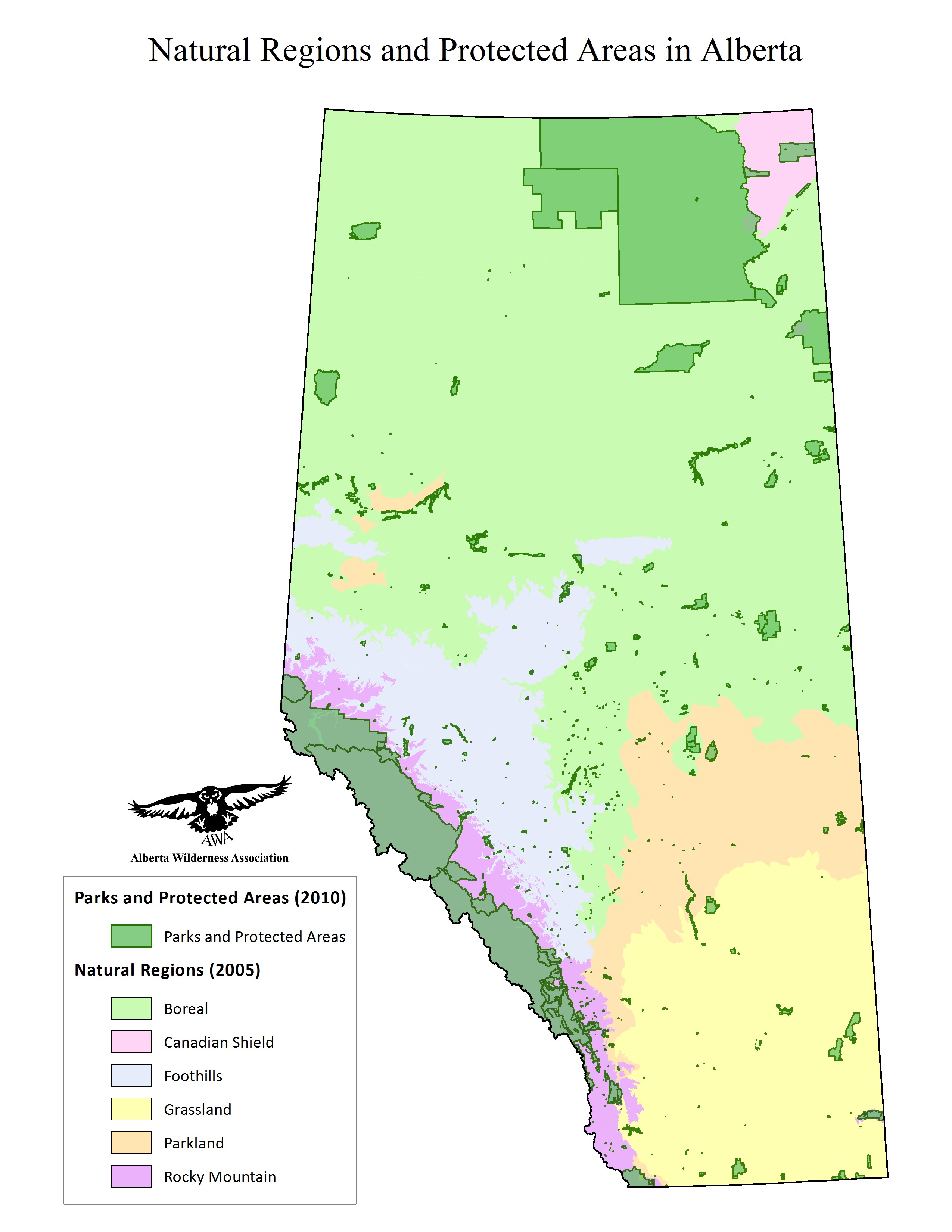
The Rocky Mountains Natural Region is 49,070 km2 in size, encompassing 7.4 percent of Alberta. It is located on the south-western border of the province, reaching from the top of Willmore Wilderness Park to the bottom of Waterton Lakes National Park. The unmistakable snowcapped peaks of the Rockies are at the core of Alberta’s cultural identity: housing wildlife, providing clean water, and playing a major role in the Alberta’s economy. The Rocky Mountains Natural Region contains 13 of AWA’s areas of concern, including (from north to south):
While these areas fall within the same Natural Region, they are distinguished by their unique ecosystems, climates and natural features, containing various blends of the Region’s three Natural Subregions: Alpine, Subalpine and Montane. The diverse landscapes of the Rocky Mountains support many of Alberta’s iconic wildlife species. Valley bottoms provide important habitat and migratory corridors for elk, deer, and grizzly bears; pristine streams thrive with native fish including westslope cutthroat trout and bull trout.
The Rocky Mountains Natural Region is also a key source of fresh water for Alberta as well as downstream central and western provinces. Alberta’s Rocky Mountains form the uppermost reaches of large catchment basins and contain the origins of the Athabasca, North Saskatchewan, and South Saskatchewan Rivers. The forested slopes of Alberta’s Rocky Mountain and Foothills Natural Regions, known collectively as the Eastern Slopes, play a very important role in storing, cleansing, and slowly releasing water in upper watersheds. Almost 90% of the river flow of the North and South Saskatchewan Rivers comes from the Eastern Slopes (Schindler 2001, North Saskatchewan Watershed Alliance 2012).
When kept healthy, watersheds buffer effects of climate change, moderate flow to reduce flooding and to supply water in times of drought, recharge groundwater resources, provide critical fisheries habitat and supply essential ecosystem services such as clean air, water, and soil (Kennedy and Wilson 2009).
As of July 2018, 29,577 km2 (or 60.2%) of the Rocky Mountains Natural Region is protected. More information on Alberta’s Protected Areas can be found here.
The remainder of the Rocky Mountains Natural Region contains unprotected public lands within the Green Area. Some are largely unregulated for multiple uses, while others have established Public Land Use Zones (PLUZs) which provide legislative controls for industrial activity and off-highway vehicle use.
Protected Areas
Protected areas within the Rocky Mountains are managed under several pieces of legislation:
The Provincial Protected Areas allow variable amounts of human disturbance. The most stringent forms of protection, such as Wilderness Areas and Ecological Reserves, prioritize undisturbed wilderness, whereas other forms of protection, such as Wildland Provincial Parks and Provincial Recreation Areas, prioritize opportunities for recreation. More information on the provincial designations for Protected Areas can be found here.
Public Lands
Albertans have long advocated for the protection of our watersheds and wildlife on public lands within the Rocky Mountains Natural Region. There are several Policies and Acts of Legislation that reflect this priority:
Eastern Slopes Policy
In 1977, the Government of Alberta created A Policy for Resource Management of the Eastern Slopes, later revised in 1984. It declared that “the highest priority in the overall management of the Eastern Slopes is placed on watershed management”, creating a series of zones to manage the impacts of recreation, tourism, industrial development and resource extraction on public lands. The most protective of these were the Prime Protection Zone, “to preserve environmentally sensitive terrain and valuable aesthetic resources”, as well as the Critical Wildlife Zone, which was intended “to protect wildlife populations by protecting habitat that is essential to those populations”. Within these zones, industrial development and OHV use are prohibited. Multiple Use Zones were established “to provide for the management and development of the full range of available resources, while meeting long term objectives for watershed management and environmental protection”. Within this zone industrial development and OHV use are permitted.
Land-use Framework
In 2008, the Government of Alberta promised to develop seven Land-use Framework regional plans that outline an approach to managing Alberta’s land and resources. Of the seven regions, the Rocky Mountains Natural Region is found in the Upper Peace, Upper Athabasca, North Saskatchewan and South Saskatchewan Regions. The Land-Use Framework recognizes that biodiversity is important for the management for healthy and resilient forests and emphasizes the watershed value of forests: “Historically, watershed and recreation were deemed the priority uses of the Eastern Slopes. These priorities should be confirmed, and sooner rather than later.”
The Land-use Framework has outlined good principles for the ecosystem-based management of the Rocky Mountains Natural Region. However, as the Land-use Framework is primarily in place to provide direction, and not legislative support, for proper management, it requires corroboration with other regulatory mechanisms to be effective.
The Public Lands Act governs public lands, particularly as it pertains to watershed protection [S. 54 (1)] and the unauthorized usage of public lands [S. 47 (1)]. Section 54(1)(d) states that “no person shall cause, permit or suffer the doing of any act on public land that may injuriously affect watershed capacity”.
Other important regulatory mechanisms include the Forests Act [S. 10], the Detailed Forest Management Plan for Spray Lake Sawmills Forest Management Agreement (2006), and the Alberta Grizzly Bear Recovery Plan (2008).
The Rocky Mountains Natural Region is 49,070 km2 in size, encompassing 7.4 percent of Alberta. It is located on the south-western border of Alberta, reaching from the top of Willmore Wilderness Park to the bottom of Waterton Lakes National Park. Major highways entering into the Rocky Mountains Natural Region include Highways 3, 1, 11, and 16, and moderately-sized urban centers within the region include Banff, Canmore and Jasper.
 Natural Regions of Alberta. Natural Regions of Alberta. MAP © AWA: JPG | PDF
Alberta’s Rocky Mountains form the uppermost reaches of large catchment basins and contain the origins of the Athabasca, North Saskatchewan, and South Saskatchewan Rivers. The forested slopes of Alberta’s Rocky Mountain and Foothills Natural Regions, known collectively as the Eastern Slopes, play a very important role in storing, cleansing, and slowly releasing water in upper watersheds. Almost 90% of the river flow of the North and South Saskatchewan Rivers comes from the Eastern Slopes, (Schindler 2001, North Saskatchewan Watershed Alliance 2012).
The Rockies stall water-laden clouds blown west from the Pacific Ocean and the water accumulates in glaciers, snowfields, soils, and forests. Forest soils with their deep layers of mosses, lichens, and organic matter are natural sponges that absorb and hold water. Trees themselves act like water towers, holding large amounts of water as it slowly passes from the ground, gathered by the roots, into the air via the leaves. From these, water is released slowly through the seasons into lower parts of the watershed.
Information gathered from the Handbook of the Rocky Mountains (Gadd, 1999).
The formation of the Rocky Mountains is punctuated by a few major stages: pre-formation, formation, and glaciation. Prior to formation, the region was covered by a thick layer of sedimentary rock, accumulated under the sea over a period of 1.5 billion years. The Rocky Mountain ranges then began to form around 140 million years ago, as a result of the collision between crustal plates; the west-coast continental shelf moved northeast over underlying granite and gneiss, causing its upper layers to accordion, break and fold into thrust sheets. This thrust faulting is the process in which large slabs of rock push over each other, resulting in the distinct strata of the Rocky Mountains. Lastly, glaciation carved out many of the Rockies’ more recognizable features. The sheer faces and U-shaped valleys are the result of glaciation during the Pleistocene and early Holocene, where the western Cordilleran and eastern Laurentide ice sheets converged upon Alberta.
While the Rocky Mountains are geologically complex, their composition can be broken into six general units (from bed to surface): a bed of granite and gneiss, an ancient layer of Rodinia rock, an old clastic unit, a middle carbonate unit, a young clastic unit, and surficial deposits from glaciation. The bed of granite and gneiss are metamorphically-formed deposits sitting just above the Earth’s molten mantle. The remaining layers are the result of sedimentary deposition during pre-formation, containing a mix of sandstone, limestone, shale, dolomite, slate, conglomerates and so on.
The Rocky Mountains Natural Region contains areas of environmental significance to international, national and provincial communities. To find out more about the specific environmentally significant areas, visit AWA’s areas of concern within the Rocky Mountains Natural Region:
Information gathered from Alberta Parks 2015.
The Rocky Mountains Natural Region is composed of three subregions: the Alpine, Subalpine, and Montane Natural Subregions.
The high-altitude Alpine subregion is predominantly tree-free, with mountains, cold winters, short summers, and high snowfalls.
The Subalpine subregion is characterized by closed lodgepole pine forests at lower elevations, open stands of Engelmann spruce and subalpine fir at higher elevations, and stunted krummholz trees near the treeline.
The Montane subregion is usually found along areas that receive warm air movements through mountain passes. Higher elevations are characterized by closed mixedwood and coniferous forests dominated by lodgepole pine. At lower elevations, the montane subregion is comprised of lodgepole pine, Douglas fir and aspen stands with open grasslands on south and western facing slopes.
Information gathered from Alberta Parks 2015.
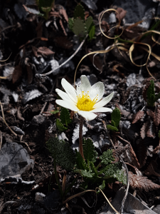
Alpine: White mountain avens, snow willow, moss campion, creeping beardtongue, mountain heathers, purple saxifrage, rock cress, double bladderwort, alpine wallflower, alpine poppies.
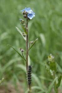
Subalpine: Forests of lodgepole pine, subalpine fir, subalpine larch, Engelmann spruce. Dwarf birch, willow, buffaloberry, wintergreens, heart-leaved arnica, bunchberry, various species and colors of paintbrush, alpine forget-me-not, sweet vetch and bearberry shrubs.
Montane: Limber pine on the tops of ridges, forests of lodgepole pine, aspen, spruce, douglas fir. Buffaloberry, snowberry, rough fescue, June grass, and many wildflowers.
Limber pine. PHOTO © C. WEARMOUTH
Alpine forget-me-not. PHOTO © C. WEARMOUTH
Eightpetal mountain-avens. PHOTO © H. MIZERA
Mammals: Elk and bighorn sheep, moose, mountain goats, grizzly bear, black bear, wolf, coyotes, pikas, marmots, Columbian ground squirrel. Woodland caribou are only found in the northern parts of this natural region.
Bird species include spruce grouse, ptarmigan, yellow-rumped warblers, Wilson’s warbler, pygmy owls, harlequin ducks, Clark’s nutcracker, Canada jay, Townsend’s warbler
Fish: The Rocky Mountains contain critical habitat for threatened native trout species, including westslope cutthroat trout (federally listed) and bull trout. Native trout thrive in cold, clean, moving water with various forms of cover such as undercut banks, pool-riffle habitat and riparian vegetation.
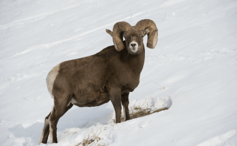
Bighorn sheep. PHOTO © AWA FILES.
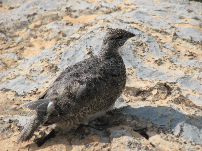
White-tailed ptarmigan. PHOTO © N. DOUGLAS
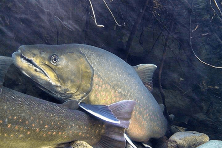
Bull trout. Photo © R. Blanchard
The Rocky Mountains have been consistently used by Indigenous Peoples since ice retreated about 10,000 years ago.
The Southern Eastern Slopes are marked by the historical uses of the Blackfoot Confederacy (Siksikaitsitapi), consisting of Kanai, Siksika, and Amksapi Piikani, for hunting and winter camps. There were buffalo jumps in various places until the buffalo herds were nearly extirpated in the 1880s.
The Rocky Mountain Nakoda’s oral history indicates they were the predominant people to have lived on the central eastern slopes of Alberta. They travelled in smaller groups in order to effectively forage and hunt in the Rocky Mountains and foothills. Unlike the prairie Nations, who depended on much larger bison herds, they depended on mountain game and vegetation. (Rocky Mountain Nakoda 2018).
The Rocky Mountains Natural Region is one of Alberta’s most popular tourist destinations, for both its incredible natural splendor and the wide array of activities it supports.
The National and Provincial Parks offer both front and backcountry opportunities, including skiing, hiking, fishing and camping. The larger town sites within the Rocky Mountains have oriented towards tourism-based economies, peppered with restaurants, boutiques, and luxury resorts. Specific activities will vary dependent on the protective status of the parks. More information on specific activities within Provincial Parks can be found here.
Public lands offer a different set of opportunities, facilitating spectacular backcountry hiking and camping, as well as equestrian use, fishing, and hunting.
The cumulative effects of increased human access, habitat fragmentation, and clearcutting are detrimental to forest health, species at risk, and water quality. Forest logging roads are often poorly built, with limited regard for hydrology, erosion and sedimentation, due to their limited use and temporary nature – once logging is complete, the roads are often abandoned. “Left-over” logging roads may still be used by recreational users and energy tenure holders. Off-highway vehicle (OHV) recreational use can increase the linear disturbance footprint created by access roads as branching trails are often created off of the main road. Poor maintenance and continued use of the access roads and subsequent trails can greatly increase the amount of sedimentation that drains into the watershed. This effect is compounded by changes in hydrology and the reduced number of trees that are responsible for water storage and related slow-release. Native Alberta fish species, such as threatened bull and westslope cutthroat trout, rely on cold clear water to thrive. Linear disturbances contribute to increases in sedimentation, which can suffocate eggs during spawning. More exposed earth also contributes to increases in water temperatures which may cause fish die-off or increased stress by inducing changes to how they feed, grow, breathe and reproduce. These adverse effects also affect humans as they can increase the cost of water purification and ultimately limit the security of Alberta’s water supply.
Due to these deleterious effects, AWA believes that industrial-scale clearcut logging should be eliminated from (a) Wild Spaces delineated on AWA’s Wild Alberta map, (b) Woodland caribou range, (c) the entire Eastern Slopes in the Bow and Oldman River watersheds, (d) Prime Protection and Critical Wildlife Zones of the Eastern Slopes north of the Bow River watershed, and (e) areas identified as environmentally significant.
Sustainable forestry needs ecosystem based models that allow natural control mechanisms to function. This will include the restoration of natural insects and diseases as well as the restoration of wildfire on the landscape.
AWA supports the Eastern Slopes Policy and strongly recommends a moratorium be imposed on motorized recreation and trail development in the Prime Protection and Critical Wildlife Zones, as well as critical habitat for species at risk.
All land uses, including industrial development, forest management plans, road building, and motorized recreational activities must be changed to comply with recovery plans for species at risk. The Alberta government’s 2008 Grizzly Bear Recovery Plan notes that “human use of access (specifically, motorized vehicle routes) is one of the primary threats to grizzly bear persistence”. While linear disturbance thresholds have been set in theory, there is no indication that management plans are being updated to implement these thresholds in practice. Similarly, critical habitat for endangered fish species have been established but largely ignored when siting access roads and limiting motorized recreation. Caribou are also affected by industrial development: competing species, such as deer and moose, are stimulated and predators can hunt along linear disturbances with increased efficiency. Woodland caribou populations require as much as 65 percent undisturbed habitat to have a better-than-even chance of being self-sustaining. Additionally, protection of caribou and other species at risk will benefit many other species in the ecological community.
AWA’s primary concerns regarding protected areas are to ensure that they remain in perpetuity and are managed in a way that they actually are protecting the ecosystem values that they were established to protect in the first place. Concerns range from insufficient funding, management, lack of enforcement, to over-development of facilities, detrimental levels and types of recreation, and commercialization. If activities that are harmful and damaging to the landscape and wildlife are allowed to take place, is an area actually protected?
June 22, 2024
Text by Devon Earl Photos by Devon Earl and Carolyn Fisher The group headed out…
May 10, 2024
On April 10, 2024, AWA received a Notice of Hearing on the applications for a…
March 19, 2024
Dear valued AWA members, As you may have heard, plans are underway to rehabilitate Banff’s…
February 22, 2024
On February 22, 2024, AWA was cc’d on correspondence from Northback Holdings Corporation to the…
February 21, 2024
The controversial logging plan in the Upper Highwood of Kananaskis is on hold, for now….
January 8, 2024
By Kennedy Halvorson Click here for a pdf copy. In 1971, American singer-songwriter John Prine…
November 28, 2023
On November 9, 2023, AWA received a letter from the legal counsel of Northback Holdings…
November 28, 2023
On October 5th, the legal counsel for Summit Coal Inc. sent a letter addressing all…
September 21, 2023
Alberta Wilderness Association wrote Premier Smith and Minister Jean on September 21, 2023 to express…
August 16, 2023
Forest management in Alberta is not sustainable or inclusive. Click here to read AWA’s briefing…
June 19, 2023
Wild Lands Advocate article by: Devon Earl Click here for a pdf version of the article….
April 24, 2023
Wild Lands Advocate article by: Devon Earl, Kristen Andersen, Beth MacCallum, with support from Elisabeth…