Draft Management Plans for the Livingstone-Porcupine
March 1, 2018
- •
- •
- •
Wild Lands Advocate article by Joanna Skrajny, AWA Conservation Specialist
click here to download a pdf of this article.
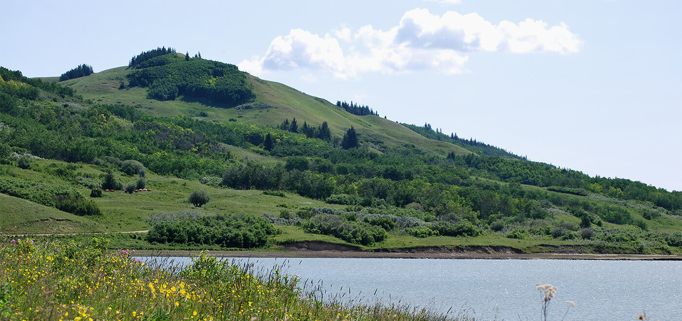
The Livingstone-Porcupine – it begins just south of Kananaskis and extends all the way to the Crowsnest Pass. It’s largely composed of public lands and contains a few protected areas such as Chain Lakes Provincial Park, Bob Creek Wildland, and the Beehive Natural Area. It’s a key area of connectivity for grizzly bears and elk; its fescue grasslands are important for ranching and conserving species at risk; it previously boasted many healthy populations of native fish. It’s one of the most iconic and diverse landscapes in Alberta.
Unfortunately, the area has suffered the same fate as many other public lands in Alberta. Too often government has turned a blind eye towards excessive human disturbance on the landscape. This decades-long pattern of neglect has fueled an uncontrolled explosion of cutblocks, pipeline right-of- ways, seismic lines, and motorized use.
Back in 2008, the provincial government conceded that Alberta was reaching a “tipping point” and that the current laissez-faire approach to land-use was no longer acceptable. The government then developed the Land-Use Framework, which divided Alberta by major watersheds, and committed to developing land-use plans within each of these watersheds. The South Saskatchewan Regional Plan, finalized in 2014, was the second of these plans to be developed. It saw placing disturbance limits on public lands in the Livingstone-Porcupine as a key priority.
After extensive consultations and planning with a variety of stakeholders including local landowners and ranchers, municipalities, First Nations, industry, recreationists, and conservationists, the government released draft Land Footprint Management and Recreation Management Plans for the Livingstone-Porcupine in mid-March.
The draft plans signal the first real attempt by the province to manage the cumulative effects of competing land uses on our pub- lic lands. They establish limits on land uses including industrial activity and motorized recreation and determine where such ac- tivities would be appropriate. As these are the first plans of this type ever developed under the Alberta Land Stewardship Act, it is important they set a positive precedent for managing cumulative effects on public lands throughout Alberta.
The Livingstone-Porcupine Land Footprint Management Plan states that its purpose is to “minimize the extent, duration and rate of cumulative footprint to achieve landscapes with healthy, functioning ecosystems that provide a range of benefits to communities and all Albertans.”
The most valuable dimension of these plans is their legal standing. The limits set on motorized access and footprint should become legally-binding and have enforce- able regulations under the Alberta Land Stewardship Act. Therefore, the question of “how much is too much” becomes a very important one. In AWA’s submission to the government, we urged the draft plans be more ambitious when it comes to limiting the activities we know damage watersheds and biodiversity.
The Land Footprint plan begins by dividing the land into two types of “zones” which are intended to provide land managers with a tool to identify high value landscapes which should be prioritized for lower intensity disturbances, as well as landscapes which are more damaged and could accommodate industrial and motor- ized use. In theory, this is a good way to concentrate disturbances and protect the most important areas; however, in practice this method almost always becomes a trade-off discussion. Unsurprisingly then these zones exclude protecting several reaches of westslope cutthroat trout critical habitat and bull trout spawning areas.
Within the more protective zone, “open motorized” trails and roads will have a limit of 0.4km/km2, while the rest will have a limit of 0.6km/km2. The plan also establishes near-stream motorized limits of0.04 km/km2 and commits to build bridges over every water crossing. These limits are good. They follow the limits recommended for grizzly bear recovery (0.6km/km2) and recognize the importance of streams and native trout.
However, we fail to follow the plan’s logic to provide an additional 0.6km/km2 of ‘Restricted Motorized Access’ for industrial use in each zone. Essentially this significantly exceeds acceptable limits of roads and trails for grizzly recovery… by a factor of two. The plan justifies this by saying that these roads and trails will only be approved if it can be demonstrated “there are no significant, long-term or irreversible impacts to wildlife, habitat, and/or watercourses.” The plan states this will be accomplished by placing limits on vehicle volume restrictions, speed limits, timing of use, noise, and road construction standards.
It makes sense to restrict motorized use on industrial roads through this designation. But, by allowing additional disturbance exclusively for industrial use, it gives the false perception that industrial roads have no long term ecological impacts.
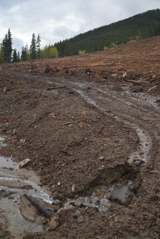
We know and have documented the very real problem of industrial roads in the Livingstone-Porcupine. Take the example of Hidden Creek, once a stronghold for bull trout (the spawning site for 80 percent of migratory bull trout in the Upper Oldman) and the home of one of the most secure populations of westslope cutthroat trout.
In November 2012, government approved Spray Lake Sawmills’ plan to log in Hidden Creek and to deviate from provincial road building standards. As we detailed in a 2014 Wild Lands Advocate article, this govern- ment approval completely ignored concerns raised by conservationists and Fish and Wildlife staff. For example, the proposed road crossed two tributaries ~60 m from Hidden Creek. This meant that suspended sediments would settle into Hidden Creek immediately upstream of a 1.8 km section of the creek with the highest bull trout redd densities anywhere in the Oldman basin.
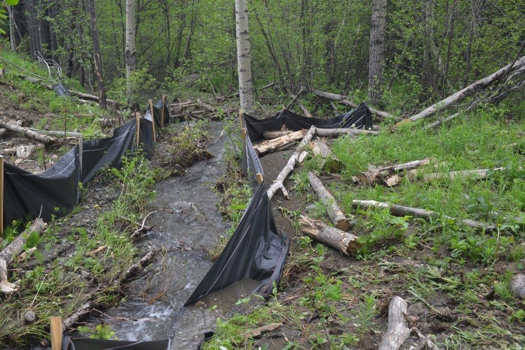
Sediment running off of cutblocks into Hidden Creek during the summer of 2013. The sediment retention barriers were clearly ineffective in preventing silt and mud from entering the creek. PHOTO: © L. FITCH.
Logging approvals went ahead and subsequent observations found that clearcut logging and the removal of the canopy caused Hidden Creek to fill with massive amounts of sediment-laden water. Following logging and the 2013 flood, bull trout redd counts dropped from over 100 redds a year to 15 in 2014. Instead of claiming the road, Spray Lake Sawmills has left it for use by off-highway vehicles (OHVs). To this day, this road is dumping large amounts of sediment into Hidden Creek, threatening further this endangered species.
The plan’s treatment of utility corridors, seismic lines, and pipelines adds to this concern. These disturbances are not held to these motorized limits and are instead categorized as “human footprint.” Industry requires motorized access on pipeline right- of-ways and other linear disturbances, so these disturbances must also be included. Looking again at Hidden Creek, there was also an old seismic trail which had been closed and was on the road to recovery prior to the return of Spray Lake Sawmills to log the watershed. To my knowledge, the Forest Service has resisted closing this seismic line again. Due to heavy OHV use, this trail has become a significant contributor of sediment to the creek. No more than 0.6km/km2 of all linear disturbances should be permitted throughout the Livingstone-Porcupine region. This limit would help to recover grizzlies and other species.
Another temporary “get out of jail free card” for industry in these plans comes from avoiding altogether any limits on activities such as industrial scale logging that obviously contribute to the size of the hu- man footprint in ways that may compromise biodiversity and watershed integrity. The Land-Footprint Plan seems to have punted this off to be dealt with in yet another plan, the long-overdue Biodiversity Management Framework. The Plan reads in part:
The framework will focus on key indicators that represent the broad range of biodiversity in the region. The indicators will reflect species, habitats and the landscapes that sustain long-term ecosystem health (e.g., headwaters areas and existing intact native grasslands). The biodiversity management framework will include the criteria for selecting the indicators.
Surely the key indicators of biodiversity need to be in place before plans to realize biodiversity are developed. And, as is so typical of the wilderness files we work on, this key framework was promised years ago. Late 2015 was when this framework was promised. AWA provided comments for the draft in early 2016; the only indication that a final plan may be in the works is the Land Foot- print Plan’s comment that, with respect to managing ecosystems and habitat to sustain biodiversity and watershed integrity, management thresholds to “guide” the size of the human footprint will be developed“(w)ithin one year.”
To its credit, once these limits are finally in place, the plan is explicit in that everybody – including Alberta Agriculture and Forestry, municipalities, the Alberta Energy Regulator is responsible for ensuring that limits are complied with. This would be a major shift from the current mode of operation, where projects often go ahead with little or no consideration for the environment.
It’s encouraging that the Land Footprint Plan has also committed to developing a Restoration Strategy for the entirety of the Eastern Slopes. Given the high amount of disturbance on this landscape, I wonder how this plan will be financed and implemented. These government activities have been underfunded for decades and it’s hard to see any indication that this government intends to change that pattern. Where industrial development opened up access to OHV use the burden should be placed on industry to fund the reclamation of those linear disturbances. The public has borne the financial burden of the destruction of public lands for too long.
The Recreation Management Plan intends to manage recreation in the Livingstone-Por-cupine in a way that follows the limits set by the Land Footprint Management Plan. It is largely focused on managing motorized recreation in the area.
The Livingstone Porcupine is currently considered to be ‘vacant public land’, which means that off-highway vehicles (OHVs) are allowed to go basically anywhere as there are no designated trails. It would be chaos if our city streets had no roads for cars to drive on, and impossible for officers to give out speed- ing tickets if there are no speed limits or stop signs! Along with the approval of the recreation plan, the province will be establishing a Public Land Use Zone which will allow the government to designate specific trails for OHV use and allow enforcement officers to do their job. It will be illegal to go off of des- ignated trails in this Public Land Use Zone.
There are currently 4,053km of linear features in the Porcupine Hills/Livingstone with an average trail density of 2.28km/km2. There is no question that this has a significant damaging impact on these ecosystems and reducing the linear density here is desperately needed.
In addition, there are almost 4,000 in- stances where roads and trails are currently crossing water bodies, most of which do not contain any crossing structures – which is illegal. Limiting the number of roads and trails located near water, minimizing cross- ings, and placing bridges over each of them will be a significant improvement. However, the plan needs to contain defined timelines and standards for when bridge installments will be completed – it’s useless, and a sad example of symbolic politics, if it will take 20 years to build them all. In addition, placing crossings over water bodies that are critical for native trout is inappropriate, as bridges are known to increase sediment delivery at either side of the bridge and elsewhere along the stream and we know sediment retention structures are largely ineffective.
Regarding trail locations, the plan intentionally appears to leave certain areas free of motorized use, which would provide benefits for wildlife and provide opportunities for other forms of recreation. For example, it proposes to designate non-motorized ar- eas in the upper reaches of the Livingstone River and remove motorized use from Hidden Creek, which would benefit westslope cutthroat trout and bull trout populations in those areas. Given the high density of road networks in the area, AWA believes there is no room or appropriate place to accommodate OHV use in the Porcupine Hills.
With respect to the OHV trail system, this system must avoid critical habitat for west- slope cutthroat trout and bull trout. Without avoiding critical habitat, it is reasonable to believe that native trout will remain in serious jeopardy. And, avoiding critical habitat is required to honour the government’s legal obligation to recover westslope cutthroat trout and protect critical habitat.
Finally, the vast majority of Albertans agree that wilderness is important, and the previous refusal to follow through and implement plans have let them, and Alberta’s land- scapes, down. This plan must do more than sit on a shelf. To that end, comprehensive on-the-ground monitoring is crucial to see if the plans are working and provide account- ability to the public. Increased enforcement is important in order to ensure these plans succeed. More public money needs to be in- vested in these functions.
These plans appear to signal an import- ant shift in public lands management in Alberta. However, I feel that the plan is overly lax on industry; one has to wonder and worry about how much of a change this will really mean to industrial development given the number of concessions that have been made in the plan and historically. While there are still outstanding concerns regarding the locations of OHV trails, the proposed plans appear to call for a significant reduction in the amount of OHV use that is currently occurring on the landscape. The cumulative impacts of land uses are taking a significant toll on our public lands throughout Alberta and the responsibility to reduce these impacts must also be shared. To this end, this is one of the first examples in Alberta where various industries, ministries, and decision makers will have to co-operate in order to achieve a common goal: better management of our public lands. AWA hope this plan is successful in achieving that goal and sets a positive example for future provincial policy.