Trends in Sales of Alberta Public Lands
September 5, 2023
- •
- •
- •
A PDF of this report can be found here.
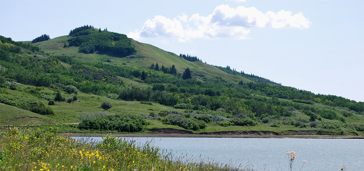
Public Lands, also known as Crown Lands, are lands managed by the federal or provincial government. Roughly 60 percent of Alberta is provincial public land, containing sections of nearly pristine wilderness and wildlife habitat, as well as heavily disturbed multi-use regions. These lands should be managed by and for all Albertans, yet the public is frequently excluded from consultation for this vital public resource.
Sales of Public Lands often lack public engagement. Alberta Wilderness Association (AWA) has previously expressed concerns on the sale of public land without meaningful consultation, particularly in lands that contain thriving ecosystems. AWA opposed the 2020 sale of a quarter-section of native prairie in southern Alberta to SLM Spud Farms, and in 2019, the sale of 140,000 acres of boreal habitat to Mackenzie county for agricultural purposes. In 2010, AWA fought against the sale of 16,000 acres of native prairie. This sale was finally cancelled by Premier Alison Redford after gaining widespread public opposition. There has been a concerning trend of surrendering finite public resources containing precious natural landscapes in favour of cropland and other agriculture uses, with minimal public input.
Summary of results
We were able to obtain records for land sales with the cooperation of the Government of Alberta Public Lands Disposition Management. Based on these records, the total number and area of public land sales have fallen in the last decade, a result that is promising for AWA’s view that Public Lands should be maintained in perpetuality. AWA continues to oppose the continued sale of Public Lands without consultation or public input.
Sales have been consistently high in Mackenzie County, an area of extensive boreal forest and many valuable wetlands. Recently, sales have also frequently been in grassland or parkland regions. Grassland and parkland in Alberta have already suffered extensive loss due to agricultural conversion and development of land, and the remaining sections of native prairie need to be protected. The sale of lands containing native ecosystems and wildlife habitat is a major concern, particularly where the sale of Public Lands results in destruction of sensitive ecosystems.
Since there is information missing from the records we obtained, patterns must be interpreted with caution. Current and previous land uses were not included in the information we received, nor was the condition of the land prior to the sale. AWA continues to advocate for a transparent and democratic Public Lands policy to manage Public Lands.
Data source and limitations
To understand the extent of Public Lands sales, AWA reached out to Alberta’s Public Lands Disposition Management for information on public land sales, where records for land sales are maintained. We were given 5348 records of land sales between 1990 and 2022. Records showed area of land sold, date of sale, and location given as either legal land descriptions under the Alberta Township Survey (ATS) or as a plan number, block number and lot number (PBL). According to the Government of Alberta document, An introduction to Alberta land titles, PBL identifiers are used for land that has been subdivided, such as a city, town, village or acreage subdivision.
Some records were missing data, such as date of sale (542 records missing) or area of land sold (535 records missing). This data loss may have resulted from inconsistent record keeping over the decades, particularly where records by non-database staff were included. There may also have been data lost during database transfers. A recent database transfer to a user-interface system, the Digital Regulatory Assurance System (DRAS), allowing online forms to be submitted, may also have affected records, although we were assured that all currently held data would be transferred. As a result of missing data, the results presented should be considered with skepticism, since patterns could be misleading.
The data received includes all land where the freehold title was transferred and contains sales as well as land exchanges. Only successful sales are included – applications for sale that were denied are not shown, and acquisitions are not provided. On requesting data for land acquisitions, we were told that land acquisitions occur across multiple departments, and the data is difficult to compile without approaching multiple Ministries. This limits the analysis to privatization of Public Lands, without comparisons of provincial public land gained.
Public Lands sales by year
From the public land sale records, the total number and area of sales peaked in 2011, at 551 sales covering roughly 33,345 hectares (Fig. 1). Recorded sales have since declined, with only 5 sales between 2020 and 2022, at 186 hectares. This is encouraging for AWA’s vision of maintaining Public Lands and the services they provide in perpetuity. Still, these sales are continuing without public consultation, and often involve native boreal forest or valuable prairie habitat sold for the purpose of agricultural expansion. AWA does not agree with the sale of Public Lands, particularly without transparency, public consultation, and sufficient environmental monitoring and management of Public Lands.
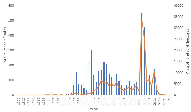
Figure 1. Public Lands sales by year. Bars represent total area of land sold in hectares, calculated as sum of area sold in each year (4079 records), and lines represent the total number of sales counted for a given year (4806 records). Records without a date of sale (542 records) were excluded from analysis.
Public Lands sales by county
To determine the approximate location of each land sale, data tables were imported to ESRI ArcGIS 10.8.2 and merged to ATS geospatial shapefiles retrieved from Altalis, a database for Alberta spatial data and imagery (https://www.altalis.com/). Quarter-sections associated with land sales were overlaid with the municipal boundaries layer, also obtained from Altalis. Data were then imported into the statistical computing program R (version 4.3.1), subset by decade, and choropleth maps for area and number of sales in each municipality were drawn using the ‘ggplot2’ package, with the packages ‘rgdal’ and ‘ggmap’ used to read and plot geospatial data (See Appendix I for complete list of CRAN packages used). Only records containing a date of sale and ATS coordinates were used for this analysis, due to logistical difficulty with identifying the municipality associated with PBL numbers, and 911 records using PBL identifiers were excluded from the analysis.
The records show both area and number of public land sales have been consistently highest in Mackenzie county, in northwest Alberta. Mackenzie county contains extensive boreal forest, as well as several important wetlands, which provide important habitat and ecological services. Wetlands are especially valuable for filtering water, mitigating flood and drought, and carbon storage. AWA has previously protested the sale of Public Lands in Mackenzie County, particularly when sales would result in the destruction of native boreal habitat for agricultural purposes. For several sales in Mackenzie, AWA and other environmental non-profit organizations (ENGOs) have raised concerns on sale of public land and fragmentation of the boreal forest and lack of public consultation. (For more information: https://albertawilderness.ca/awa-cpaws-concerns-with-the-additional-sale-of-public-lands-to-mackenzie-county/; https://albertawilderness.ca/public-lands-should-not-be-sold-to-mackenzie-county/).
As well, in recent years, while the total number of sales have declined, the relative area of recorded sales in southern Alberta is increasing. Alberta’s south comprises the grassland and parkland regions, both areas that have are already heavily disturbed. In Alberta’s grasslands, where the majority of the province’s species at risk are found, over 75 percent of native habitat has already been lost to agricultural, industrial or other uses, and protection in the prairies is severely lacking, with only 1.25% of grasslands and 0.9% of parkland protected. Most of this land has been sold with no public discussion, and with so much of the native prairie ecosystem already lost, Public Lands in this area must not be privatized and destroyed. AWA has already spoken out against sales of native prairie, such as in the counties of Taber and Vulcan, particularly as much of this land is purchased for agricultural expansion. Agricultural lands are far less diverse than the native prairie they replace, resulting in the loss of vital habitat and ecosystem services. (For more information: https://albertawilderness.ca/news-release-public-land-sale-opposed/; https://albertawilderness.ca/news-release-public-land-sale-opposed/; https://albertawilderness.ca/2012-09-26-awa-news-release-new-bill-to-address-public-engagement-in-public-land-sales/).
Many of the sales since 2020 appear to be on unconverted lands near cropland, and are prime targets for agricultural expansion (See Appendix II). The loss of high-quality Public Lands for cropland is a continuing threat to native ecosystems, causing destruction, degradation and fragmentation of wildlife habitat. Conversion of forests and grasslands, in addition to reducing biodiversity, can increase soil erosion, release carbon and result in more temperature extremes. Public Lands that contain native habitat are invaluable, and their sale reflects a failure to value and manage these lands to benefit all Albertans.
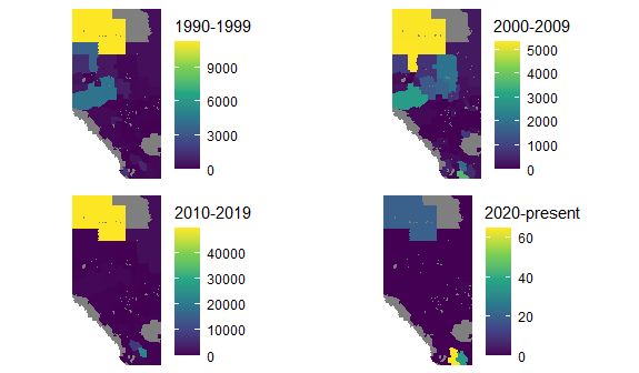
Figure 2. Area of public land sold (hectares) divided by municipal boundaries in Alberta. Area represents the total area of land sold for each decade within a county. Only records with ATS identifiers were included (3928 records).
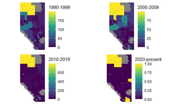
Figure 3. Number of public land sales in each area divided by municipal boundaries in Alberta. Number of sales represents the total sales for each decade within a county. Only records with ATS identifiers were included (3832 records).
Conclusion
Based on the records, sales of Public Lands have declined in recent years, although the sale of Public Lands that results in the destruction of native habitat for other land uses remains a concern. Land sales have been consistently common in Mackenzie County, with several more recent sales in the prairie region, both areas that contain sensitive and disappearing habitats. Information on the purpose of land sales, environmental assessments for lands prior to sale and the use of lands that are sold remains hidden, and along with missing information in the sales records, makes interpretation of land sales uncertain. We are only able to report on the patterns observed in the sales records.
AWA has long advocated for a Public Lands policy that is transparent and democratic, and that maintains Public Lands in perpetuality. The sale of Public Lands, especially lands that contain native habitat and vulnerable ecosystems, removes public resources and frequently results in the loss of habitat as lands are converted to cropland. We were able to obtain sales information by requesting records from the Alberta Public Lands Disposition Management, though the information is not easily available, and missing data makes analysis and interpretation difficult.
Public Lands should be managed for the benefit of all Albertans, and public lands sales should not occur without public consultation. Public Lands provide many benefits, outweighing the gains of sale, especially when sales result in the destruction of native habitat for other land uses, including agriculture and energy extraction. Information on Public Lands should be public, clearly and consistently recorded, provide location, condition and date of sale. A Public Lands Policy is needed to promote a transparent process for Public Land sales, and to manage Public Lands in a manner benefiting all Albertans.
Appendix I: Packages used for data analysis in R (version 4.3.1)
Table 1. All CRAN packages used in data analysis.
| Package | Description | Version |
| maps | Draw Geographical Maps | 3.4.1 |
| rgdal | Bindings for the ‘Geospatial’ Data Abstraction Library | 1.6-7 |
| ggmap | Spatial Visualization with ggplot2 | 3.0.2 |
| sp | Classes and Methods for Spatial Data | 2.0-0 |
| ggplot2 | Create Elegant Data Visualisations Using the Grammar of Graphics | 3.4.2 |
| plyr | Tools for Splitting, Applying and Combining Data | 1.8.8 |
| gridExtra | Miscellaneous Functions for “Grid” Graphics | 2.3 |
| rstudioapi | Safely Access the RStudio API | 0.15.0 |
| data.table | Extension of ‘data.frame’ | 1.14.8 |
| viridis | Colorblind-Friendly Color Maps for R | 0.6.3 |
| broom | Convert Statistical Objects into Tidy Tibbles | 1.0.5 |
| mapproj | Map Projections | 1.2.11 |
Appendix II: Location of recent sales
Since 2020, there were six sales of Public Lands on record. Of these six, five have an associated ATS identifier. While we did not have the exact boundaries for each sale, we were able to locate the quarter-section listed for each sale. We examined satellite imagery, provided by Google Satellite, to understand the environment where these sales were occurring.
All five sales considered were near agricultural land, with four of five appearing as uncropped and minimally developed areas within regions of extensive cropland. One parcel (QS-SE SEC-31 TWP-009 RGE-13 MER-4) is known to have been sold to SLM Spud Farms for potato cropping. While the buyers and land use for the remaining lands is less clear, the proximity to extensive cropland suggests similar agricultural or developmental use for these lands.
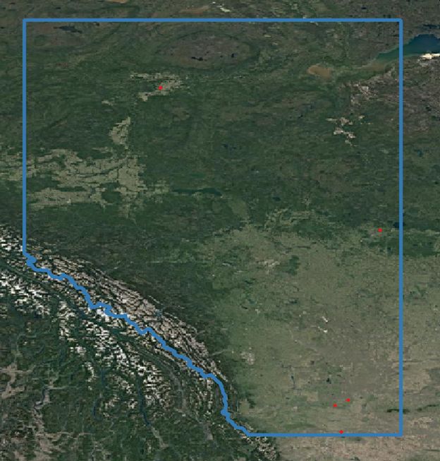
Figure 4. Location of Public Lands sales from 2020-2022. Five locations identified based on ATS identifiers are shown in red. The border of Alberta is outlined in blue. Satellite imagery provided by Google.
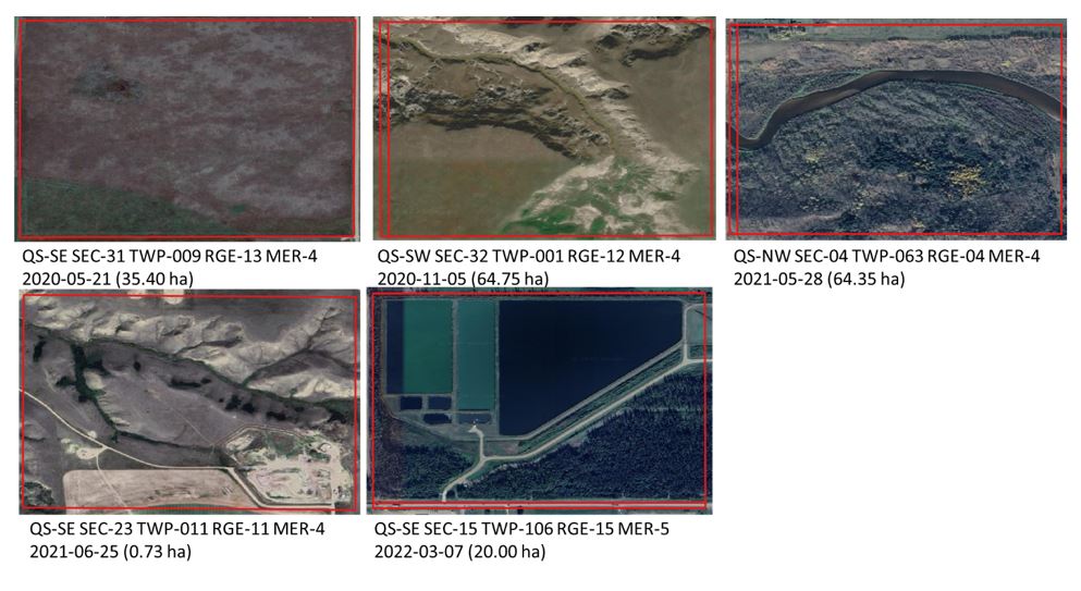
Figure 5. Satellite images of quarter-sections where land sales were recorded 2020-2022. Locations are ATS legal land descriptions, with the date of title creation and area of land sold in hectares provided under each photo. Exact boundaries of lands sold are not known.