Sandhills, Sawmills, and the Forests Surrounding Horse Lake
October 16, 2023
- •
- •
- •
- Areas of Concern
- Biodiversity
- Groundwater
- Headwaters
- Issues
- Native Coldwater Fish
- Wetlands
- Wildwater
Read the pdf version here.
By Sharlene Fritz and Devon Earl
With imminent logging in the Ghost Watershed, this article pairs the local knowledge of Sharlene Fritz (Part 1) with the
assessment of the Alberta forestry model by Devon Earl (Part 2). The two writers hiked together to Horse Lake
this summer.
Part 1 – The Journey by Sharlene Fritz
The mayfly lands on my shirt sleeve, delicately balancing on a crease. Today is the day it must mate and then die. Completing their life cycle on land, these white-laced winged creatures have spent the last several years underwater, growing and morphing in their nymph stage. These intricate insects swarm in a cloud above the beaver pond, itself a delicate balance of mud, willow, and will.
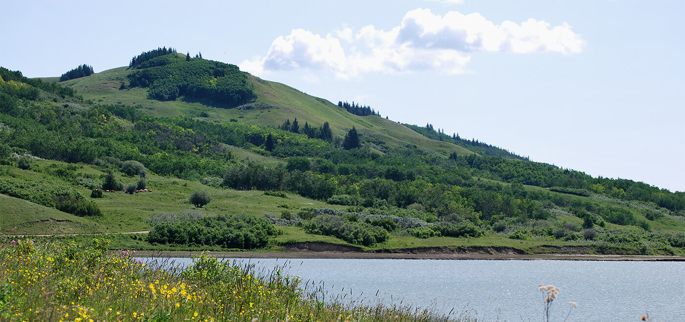
We are on our way to Horse Lake, a small lake tucked into a pocket of foothills that drains into Aura Creek, a tributary to Waiparous Creek, and critical habitat for westslope cutthroat trout and bull trout. Industrial scale logging began in this sub-basin in 2013 and more is planned for the fall 2023-2024 season.
Let me take you there.
Meeting in Cochrane, we travel west along the 1A Highway and turn north onto the Forestry Trunk Road, or Highway 40. Completed in 1952, this road connects the Bow River valley with the Red Deer River valley. The name hints at the roots of its creation. The Forestry Trunk Road was largely built through the Rocky Mountains Forest Reserve established by the Dominion of Canada in 1910 to achieve “the reserving of timber supplies … and the preserving of the water level in streams by conserving the timber on the upper watersheds.” The Eastern Rockies Forest Conservation Board (ERFCB), a partnership between federal and provincial officials lasting between 1947 and 1972, initiated the road construction to allow for better management of these “water towers for the prairies,” including for fire detection and suppression.
Driving the shoulder-less road, we pass by the intersection to Stoney IR 142B, multiple ranching operations, a handful of small settlements, two retreat centres, a Water Survey of Canada hydrometric station below the bridge over Waiparous Creek, and a paintball company. The pavement ends at the cattle guard, a boundary for both the road surface and the jurisdiction. Here we enter Crown land, the Forest Reserve, its boundary now announced by a sign signalling a shift in emphasis, the Ghost Public Land Use Zone (PLUZ). Staging areas, off-highway vehicle (OHV) trails and vehicles unloading riding machines inhabit the landscape. We cross the Waiparous Creek again just north of the Waiparous Creek Campground, one of several Public Recreation Areas (PRAs) in the Ghost PLUZ. A sharp hairpin turn leads us onto Camp Road, named by a local ranching family for the summer camp they set up when their cattle grazed these valleys. We drive over a large, bottomless culvert, a recent installation completed by Trout Unlimited Canada to replace five hanging culverts in another westslope cutthroat trout-bearing stream.
Skirting another OHV staging area and turning south, we are now driving on a historic road, the Eau Claire tote road. Commercial logging began in the Ghost with the arrival of the Eau Claire and Bow River Lumber Company, first conceived of by an Ottawa lawyer and then executed by a company out of Eau Claire, Wisconsin. The owners obtained timber berths in the upper Bow, Spray and Kananaskis valleys in the late 1800s. In 1906, they received a timber berth in the northern part of the Ghost Watershed. To supply and staff their logging camps, they built the Eau Claire tote road, a transportation artery with several branches. But the logs took a different route. Felled in the winter, the harvested trees were piled up on or beside the frozen Waiparous Creek at one of three dams. In the spring, nature’s force or human muscle burst the dams, releasing the logs down to the current of the Ghost River, further on to the Bow River and finally floating to their destination at the Eau Claire sawmill in Calgary. Remnants of their camps, dams and most noticeably, the tote road can be found in the Ghost Watershed. Until the building of the hydroelectric dam that created the Ghost Reservoir in 1929, this log drive was uninhibited. Mainly horse and human-powered, these logging operations removed timber but not at the industrial scale and pace observed today.
We park at the fork to the Whispering Pines bible camp, settle into our packs, and begin hiking the Eau Claire tote road, which is now a designated OHV trail.
We quickly encounter a 2013 cut block and note the lack of regrowth. Trees in the minimal stand retention patch dwarf the tiny and sparse pine seedlings. Aspens spread out in the open sunshine-filled space. Following the track, we cross an unnamed tributary to Waiparous Creek on a bridge that few people seem to use. Wider OHVs ford the creek just upstream of the bridge. Leaving the designated trail, we hike up a seismic line through more of the 2013 timber harvest. We steadily ascend to the ridge, taking the “chicken trail” to avoid the steep climb. Gaining views of the Rocky Mountains, we catch our breath and talk about the reclaimed haul roads, still visible 10 years on. Tracing the spine of the sandstone ridge, we revel in the cool shade of the conifers that give relief from the hot, exposed cut block opening. Like ribs protecting lungs, the fire-origin stands of spruce and pine on parallel ridges guard the wetlands beneath. Flagging tape appears downslope, a precursor to the upcoming 2023 SLS harvest. The northeast facing slope to our left nurtures large mature spruce sheathed in lichen. Their wide bases, tall tips, and 100+ growth rings make them the old sentinels of this area. They are marked for harvest. The ridge walk ends in an open, scoured bowl, known as the Sand Hills or Sand Ridge by the locals. Stripped of vegetation by relentless dirt bike tracks, this soft white sand sits exposed. These surficial sand deposits are aeolian, or wind borne, and make a fragile substrate. Despite being officially closed to OHV use, this area has been churned into an open sandpit by the wheels of dirt bikes.
We follow the rutted sand track to an undercut bank draped with juniper and kinnikinnick. Two gaping holes invite investigation, known to be former wolf dens. Wildlife camera footage revealed nighttime forays of the alpha male and female. Today, evidence of this canine presence appears as scat piles and clearly distinguishable tracks. Anecdotes from locals describe the once-abundant presence of moose in this valley.
Descending the last of the sandy slope, we come across another piece of flagging on the lone spruce encircled by dirt bike tracks. We’re now heading through a forest filled with moss, lichen, game trails and flagging for the proposed haul road. A short distance along, we hit another historic trail, the old ranger route that connected the original Aura Ranger Station to the one at Harold Creek. Another unnamed spring-fed trickle flows into Aura Creek, a Waiparous Creek tributary, and designated critical habitat for westslope cutthroat trout and bull trout. Pure-strain westslope cutthroat populations have been confirmed in this curving, willow-lined aquatic ribbon. Today, the way is spongey, wet from recent rains and seepage from the ground. Winding our way along the old ranger trail, we hear the cries of a red-tailed hawk before we see it circling above, warning the willow-birch wetland of our arrival. Muskrat tracks in the mud parallel our own. We are flanked by 2014 cutblocks on our right where regeneration falters. In the distance, we see part of the 2020 clear-cut openings, the full extent of the long NW-SE trending strips is hidden from view.
We know we are close to the lake but cannot quicken our pace. Frogs in multitudes bring the sedges alive with their gutsy leaps. Avoiding a submerged hiking boot, we ourselves hop from hummock to hummock, making our way to the lake’s edge, an undefined boundary. Basking in the beautiful arrival, we make out shorebirds, waterfowl and the indescribable peace that comes from being in foothills wilderness.
Pressing further up the ranger trail, we catch a glimpse of the 2020 haul road through the pileated woodpecker cavity-nesting condo units. Goldenrod, yarrow, blue bell and fireweed colour the scene. Aspen groves give way to dwarf birch, in turn giving way to sedges, the upland transitioning to wetland. We’re looking for the peat deposits and a way to extend the day. We find the peat layer as a dark mat, exposed by the incised stream. Reluctantly, we turn around. In a patch of forest slated for harvest in the fall of 2023, a spruce grouse mother scares up at the side of the trail, perches on a fallen aspen trunk and quietly coos a warning call to her young. Three in her clutch, they all heed the warning and move from one side of the trail to the other. Some confidently, others paralyzed with fear at first, all eventually making it to safety. A delicate balance.
Part 2 – The Forestry Model by Devon Earl
Concerns about excessive logging in the Ghost watershed are not baseless. Science has established that too much clearcutting can negatively impact biodiversity, hydrologic regime, and carbon sequestration; the functioning pillars that hold up ecological integrity. The area in question has been recognized for its outstanding ecological value through various avenues: The Ghost River Integrated Resource Plan (IRP, 1988) identifies it as a critical wildlife zone; a report commissioned by Spray Lake Sawmills (SLS) identifies it as a remnant high-conservation value forest; and researchers from the University of Waterloo found Horse Lake to contain the most rich and abundant array of songbird diversity of all their sampled sites along the Eastern Slopes. Recently, a wildlife biologist identified 54 bird species on one early morning survey, six listed as sensitive. These Horse Lake bird counts show that the area has a wide range of ecological niches, or habitat opportunities, for critters of all walks of life.
The Aura Creek sub-basin encompasses about 1,035 hectares of forests, sandhills, and wetlands. Within that area, 270 hectares of forests have been logged since 2013, and the additional 65 hectares that are planned in 2023 will result in at least 30 percent of the area being disturbed by forestry. At this rate, it is very likely that logging practices will have a hydrologic impact. This upcoming harvest has the potential to affect the timing and volume of water flow. Clearcut areas do not reabsorb water as well as forests, and this may result in more runoff and creek flooding in the spring, poor groundwater recharge, and low water availability in the late summer and fall. Wetlands are particularly susceptible to evaporation when the forests that surround them have been logged. As climate change drives us towards increasingly worse wildfire seasons, the value of wetlands as a needed fire break is increasingly evident.
Changes to hydrologic regime are of particular importance to cold-water native trout. Despite Aura Creek being listed as critical habitat for bull trout and westslope cutthroat trout, Fisheries and Oceans Canada (DFO) has not stepped in to stop the probable habitat destruction that will result from logging more forests in the Aura Creek drainage. DFO is responsible for administering the Fisheries Act, and the Species at Risk Act when it comes to aquatic species at risk like endangered native trout. However, their questionable approach tends to allow habitat destruction if habitat is made up elsewhere. It remains unclear to us when permits are required by DFO for logging operations and when they are not, and why these logging plans would be permitted or exempt from requiring a permit. In either case, it is irresponsible to allow the destruction of native trout habitat, especially when these fish have endured a significant decline in their historic range largely due to forestry, oil and gas, and other intensive land use and industrial developments. Endangered native trout, like many other species at risk, have no room left to compromise their habitat and continue to survive.
The public has reasonable doubts about the sustainability of forest management in Alberta. Logging plans often seem to pop up in areas that are important for recreation or ecological values shortly before they are set to begin. Of course, these plans have often been in the making for many years, but because of a lack of transparency and public participation in the planning process, it is difficult or impossible for concerned parties to find out about plans until it is too late to oppose them. Public input is invited during the Forest Management Plan (FMP) stage, which happens once a decade, but concerns about specific cutblocks are dismissed as premature and better dealt with at the Annual Operating Plan (AOP) level. Making effort to provide meaningful, locally based knowledge into the AOP, the public is brushed off by officials who comment that concerns were addressed at the FMP stage. All the while, it is difficult for anyone to access relevant planning and monitoring documents like stewardship reports and regeneration data. Though forests are a public resource, they are treated as the property of the company holding the Forest Management Agreement (FMA). FMAs between the provincial government and forestry companies are locked in for 20 years to give companies security in their tenure, with likely renewal after the 20 years are up. This system was not designed to ensure security for other users of the forest, including wildlife.
Public trust is further fragmented by industry greenwashing. If you take industry’s word for it, you would believe that forests past a certain age will simply decay and die, and therefore harvesting older forests does the ecosystem a favour. This is fiction that intends to paint the forestry industry green. In the absence of logging or natural disturbance, trees can grow to become very old. Even in a place like Alberta where fire is a natural disturbance that forest-dwelling species evolved to tolerate and even depend on, many stands and patches of trees are missed by fires leading to the presence of forests well above the average age throughout the landscape. This point is driven home by the fact that many species evolved to rely upon features of old-growth forests, like the pileated woodpecker and barred owl. Logging does not emulate natural disturbance by fire and should not be treated as a safe or necessary replacement.
Industry points to their operating ground rules (OGRs) as the environmental regulations that ensure sustainable practices, but OGRs are not based on science, and don’t set strong enough environmental protections like large enough buffers around water bodies to protect fish or large enough patches of living trees to retain biodiversity. If they did, of certain native trout species. Some forestry companies operating in Alberta point to their Sustainable Forestry Initiative (SFI) certification as proof of their sustainable practices; However, the SFI standard does not measure any outcomes of sustainability and is currently under review by the Competition Bureau of Canada for false and misleading claims; they cannot claim that products come from sustainably managed forests while not measuring any sustainability outcomes such as biodiversity or species at risk recovery.
Our visit to Horse Lake gave us an opportunity to take in the natural wilderness of this special area that won’t be the same after logging takes place this fall. Although it is sad to know that we may not get a chance to see this place again the way it is now, I felt privileged to have stepped foot there. Spending the day spotting frogs in the wetlands as we trod carefully through them, listening to bird calls, and peeking into wolf dens, I felt hopeful. As more people are venturing into the natural wilderness, more people raise their voices to advocate for its protection and responsible management. I have seen anger, frustration, and sadness channelled into positive environmental change, and that is my hope for our forests. I see a future where all values of the forest are considered and weighed thoughtfully in the decisions about where and how to harvest timber. A true ecosystem-based management regime can offer jobs and timber as well as ecological integrity, a stable climate, and a healthy water supply.