Horseshoe Canyon: Scarring, Endangering A Gem of the Badlands
March 1, 2019
- •
- •
- •
Wild Lands Advocate Article By Ian Urquhart
Download a pdf version of this article here.
Stewardship…it’s a value as old as conservation itself. Aldo Leopold’s idea of a “land ethic” is one important version of this stewardship. It’s nothing less than the conviction we have a moral responsibility to the natural world. Or, as the Aldo Leopold Foundation put it: “At its core, the idea of a land ethic is simply caring: about people, about land, and about strengthening the relationships between them.” Over the years AWA has recognized and applauded families and institutions such as the Biggs, the Taylors, the Heydlauffs, and the Waldron Ranch for their stewardship of the land. They have practiced the land ethic for the betterment of all.
But what happens to stewardship concerns and efforts in the event good stewards decide they need to sell their properties? That’s the question at the heart of this article.
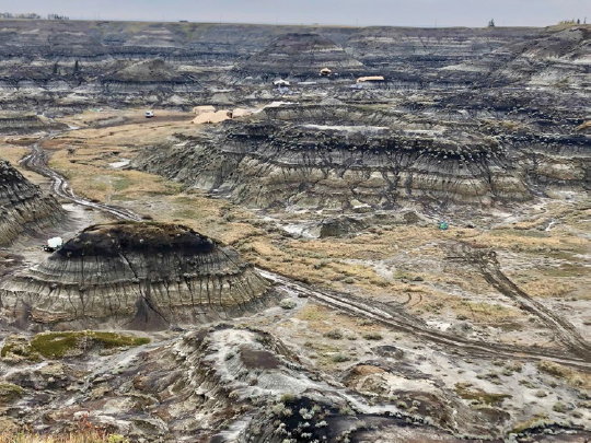
Tent encampment with some of its attendant vehicles in Horseshoe Canyon, Fall 2018. Note the extensive rutting of the terrain caused by the vehicular traffic. PHOTO: © J. GOODINE
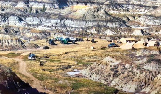
Trucks, side by sides, tents, earth mover, forklift in the canyon – none from the Cretaceous period. PHOTO: © C. GROENEVELD
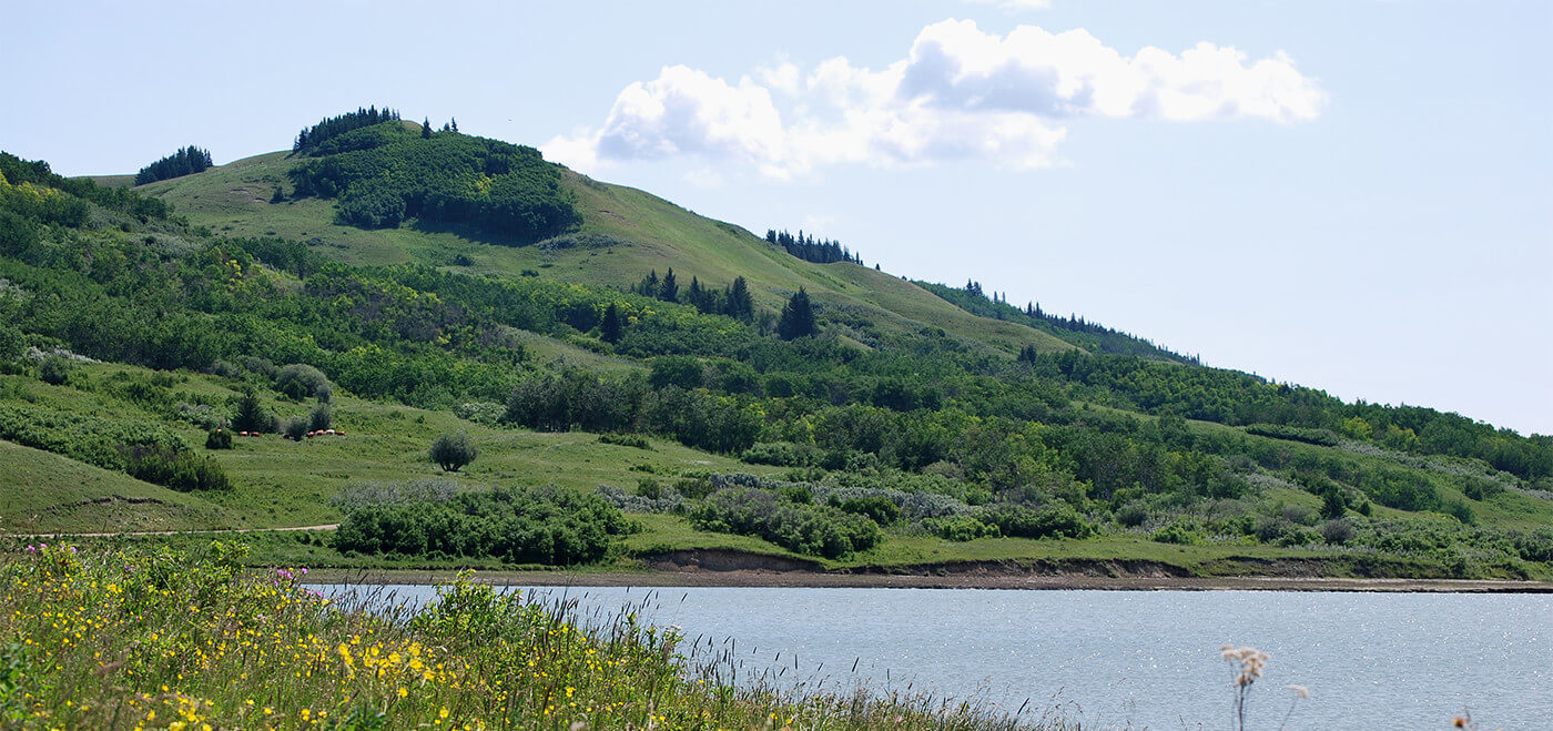
What follows is the developing story of the Lowen family. Edward Thomas (Jack) Lowen purchased part of Horseshoe Canyon – a spectacular example of Alberta’s badlands geography in the 1940s. The property stayed in the family for the next 70 years. Jack Sr. passed it on to his sons Ralph and Jack Jr. The Nature Conservancy of Canada (NCC) describes the canyon, located just west of Drumheller, as “one of the best-known sites in the Canadian Badlands.” For NCC, the aesthetics plus the canyon’s representation of prairie, wooded coulee slopes, and badlands habitats make Horseshoe Canyon ecologically significant. It’s a beautiful, significant site.
Several years ago the children of Ralph and Jack Jr. came to a hard decision – they would sell their portion of the canyon to Kneehill County. The children – Judy Goodine, Cindy Groeneveld, Janice Blackie-Goodine, and Janice’s son Sean Blackie – endeavoured to ensure that whoever bought their lands would be obliged to preserve them in their natural state. By virtue of this, the developer who approached the family with his dream of building a golf course in the canyon was never invited to make an offer on the property. Protection, not profit, was key to their outllook.
These landowners thought Kneehill County, the local government west/northwest of Drumheller, would respect their wishes. In a September 2018 letter to the County, the lawyer for the Lowen children wrote: “It was represented to my clients that the County’s decision in purchasing the lands was to preserve the lands in their natural state. It was this representation that persuaded my clients to sell the property to the County.” To try to ensure that Kneehill County upheld its end of the bargain, the Lowen family insisted on attaching a restrictive covenant to the sale of their property. That covenant stated, in part, that “the Lands are to be protected and preserved for environmental and conservation purposes.” To date, the County certainly hasn’t met the family’s expectations of what that phrase means and what would be done to their property. It may be up to the courts to decide if Kneehill County has fulfilled its legal obligations under this covenant.
The Lost World
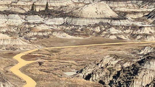
The gravel road built as part of the remediation effort now scars the canyon. PHOTO: © J. GOODINE
This story begins roughly 70 million years ago in the late Cretaceous period. Then dozens of dinosaur species, including the Albertosaurus – a smaller relative of Tyrannosaurus Rex, roamed the badlands bordering the Red Deer River valley. In what we now call the Horseshoe Canyon Formation, the dinosaurs lived and died in diverse marine habitats that then were the norm. The first recorded Western discovery of an Albertosaurus fossil in this region occurred in the late 19th Century. In June 1884, as recounted by Tanke and Currie more than 100 years later, the Geological Survey of Canada geologist Joseph Tyrell found Alberta’s “first good dinosaur specimen – the skull of an Albertosaurus…” Sadly the quality of the specimen suffered because Tyrell’s expedition had neither the time, the tools, or the logistical experience and means to collect and preserve this specimen well.
Horseshoe Canyon’s dramatic aesthetic character testifies to the erosive power of wind and water over the millennia. The Canadian Encyclopedia traces the initial formation of many examples of the badlands to the retreat of the Laurentide ice sheet approximately 13,000 ago. That glacial meltwater sculpted the shale, siltstone, and sandstone formations into what Travel Alberta calls today “an eye-popping sight.” There is no disputing that. For me, perhaps because the canyon boasts the fossilized legacy of the dinosaurs, the place has a surreal, other-worldly character. To set your eyes on the multi-colored rock layers or stripes on the hills in the canyon might be your introduction to stratigraphy, a branch of geology that studies the layering of rocks such as the sedimentary ones found in the canyon. Regardless, to descend into the canyon is to go back in time.
Balancing Legal Risks and Public Enjoyment
Given its proximity to Highway 9, the canyon rim and its unofficial viewpoint have long been a popular place to stop. As the Nature Conservancy points out it is “a favourite spot for tourists to catch their first glimpse of this unique aspect of Alberta’s natural heritage.” For 40 years, Louisa Lowen, Ralph’s wife, operated a refreshment stand at the rim of the canyon. There she provided hamburgers, ice cream, and other essential rations for anyone who was about to venture into the canyon. For Louisa’s children and grandchildren, the refreshment stand provided a chest of happy memories. Grandchildren helped serve the visitors and welcome them to their family’s special place. And, when the kids weren’t helping out you’d likely find them scrambling up and down into the canyon. I’ll wager such fun made its own dent into Louisa’s ice cream supply. Steve and Sharon Wolchina were other fixtures on the canyon’s rim where visitors could see some of the types of fossils found in the badlands.
Travel Alberta and other organizations encouraged the public from far and wide to come and visit the canyon. You might have thought then the canyon lands were public. They weren’t. When people visited the canyon and picked their way down the slope to the canyon floor, more often than not they were on private property – Lowen land. Since the portions of the family’s land not bordering the canyon were fenced, Janice asked her father one day why they had never put a fence up along the top of the rim. Jack Jr. told his daughter that it was “because Grandpa said this was God’s country and everyone should have access to the beauty of this land.”
But, concerns about public safety and landowner liability came with the visitors who wanted to take in the beauty of this badlands gem. If someone fell as they scrambled down the predominantly clay hillside into the canyon would they try to hold the Lowens responsible? Over the years at least a handful of people needed to be helicoptered out of the canyon due to mishaps of one kind or another.
The risks of legal action and the costs of securing liability insurance led the Lowen children to approach Kneehill County. Would the County help the family bear the costs and risks associated with allowing the public to negotiate these private lands? The answer was no. But, the County countered by raising the possibility of a land sale. Would the family consider selling their quarter-section of land to the local government? In light of the public safety concerns, Judy, Cindy, Janice, and Sean faced a hard choice. Hang on to the land and face risks in the future or sell the land to Kneehill County.
I had the opportunity to meet some of the family this past January. Judy Goodine invited me to talk about the state of the canyon with herself, her husband Doug, Judy’s sister Cindy Groeneveld, and the Wolchinas. They impressed me as people who cared very deeply about the health of the canyon. Keeping the canyon in as pristine a condition as possible was clearly uppermost in the minds of the family when we talked about the future of the canyon. Their love of that landscape made it clear that, when they were considering the future of the canyon, they needed to be assured the landscape wouldn’t be despoiled. As Doug Goodine mentioned, if the family wanted to maximize the dollar value of the land they would have put it on the market in the hope of attracting a land developer. But, they didn’t. Their passion for preserving the canyon was clear from talking around the Goodines’ kitchen table that Sunday afternoon. Their decision to consider the County’s unsolicited offer was rooted in the family’s belief that, if the County bought the property, the local government would be a good steward of the lands.
The Restrictive Covenant
A restrictive covenant is a promise not to do something. Such covenants are intended to ensure that certain activities or land uses will not take place when property passes from one owner to another. Both Cindy and Judy were very worried that, good intentions aside, the County would balk at offering the protection for the canyon they wanted to see. Therefore, they wanted to make the County’s conservation commitment binding and saw a restrictive covenant as the way to realize that.
The restrictive covenant Kneehill County agreed to when it purchased the Horseshoe Canyon parcel begins by stating the overriding intent of the agreement. The canyon lands “are to be protected and preserved for environmental and conservation purposes.” It then proceeds to outline seven stipulations, restrictions, and provisions. The first clause stipulates that the lands “shall not be developed.” Clause 5, one forbidding the new owner from subdividing the lands, affirms that the more profitable path the Lowen family could have followed cannot be pursued by the County or any subsequent owners.
Clauses 2 through 4 of the covenant temper slightly the “thou shalt not develop” message of the first clause. The second clause states that lands above the canyon may be developed – but “solely” for establishing a day-use area or an overnight campground. Neither imagined development extending down into the canyon and disrupting the ecological integrity therein.
The third and fourth clauses detail the very minimal level of development within the canyon the Lowen family thought the County was committing to. According to the third clause, the County could alter or develop the lands in the canyon “to allow for walking trails, bicycle paths, or such other minimally environmentally invasive alternations (sic) or developments.” (my emphasis) The fourth clause prohibits all off-road vehicles from entering the canyon. The only exception to that blanket prohibition allows four-wheel drive or off-highway vehicles to enter the canyon if they needed to be there to build or maintain the permitted minimal alterations and developments.
Through securing these terms in the restrictive covenant the Lowens were confident the County would preserve the integrity of the canyon. They thought their reputation as local landowners who were, in the words of the Nature Conservancy, “similarly dedicated to maintaining the canyon in its natural state” would be intact.
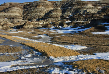
A closer look at the gravel road on the canyon floor. Note how raised the road is from the floor and how the road redirects surface water. PHOTO: © I. URQUHART
Lost in Space, Found in Horseshoe Canyon
Some may see the County’s subsequent actions as ones questioning its commitment to honour the spirit of a covenant intended to protect and preserve lands “for environmental and conservation purposes.” I certainly questioned the County’s interpretation of what constitutes “minimally environmentally invasive” alterations and development after visiting the canyon in January 2019. Instead of a bicycle path, my descent into the canyon came courtesy of a gravel road more than three metres wide. It must be one helluva bicycle that needs such a road in order to enter the canyon. Since there were no walking trails or bicycle trails at the bottom of the canyon this road certainly had not been needed to construct any of the permitted alterations or development anticipated in clause 3 of the covenant.
I have to admit one thing here. I knew before my January trip to the canyon that a gravel road would greet me there, a gravel road not built to construct/maintain walking or bicycle trails. I knew that, as counterintuitive as I regarded it, much of that gravel road was part of an effort to remediate damage inflicted to the canyon lands. The ultimate source of the environmental damage was the County’s interpretation of what activities the covenant permitted in Horseshoe Canyon. The County’s interpretation allowed the activities that prompted the eventual need for reclamation.
What type of canyon activities did the County believe were consistent with the covenant’s environmental and conservation commitment? Would you believe making the canyon a stage for a television series? That’s right…the County negotiated an agreement with the Netflix series “Lost in Space” to film in the canyon for approximately two weeks in September 2018. As photos taken by Judy Goodine and others show so clearly, an extensive, multiple tent encampment was erected in the canyon. In one photo, seven 4x4s, five side-by-side OHVs, a shooting boom forklift, and a skid steer earth moving machine all are operating in the canyon. Without a road in the canyon bottom, these vehicles essentially carved one out on the valley floor by following a much less intrusive walking trail. With the rains that came in mid-September the canyon floor became a perfect canvas for these vehicles to disrupt the native vegetation and leave extensive tire damage throughout.
The family felt betrayed, not simply because of the activities, but because when they owned the land they had privileged protection over profit. The few weeks of filming in the canyon generated $89,000 in revenue for the County. Overnight the canyon became the County’s most significant source of parks revenue. Turning the canyon into a revenue-generator for the County was never part of the future the family imagined.
Concerns Dismissed, Canyon’s Integrity Put at Further Risk
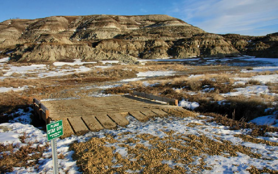
One of the new permanent bridges constructed as part of remediation in the canyon. PHOTO: © I. URQUHART
Very soon after the Lowen sisters discovered what was taking place in the canyon they retained a Drumheller lawyer to explore the situation further. William Herman wrote to Al Hoggan, the Chief Administrative Officer of Kneehill County. Herman’s letter stated that the Lowen family sold the property to the County because of the County’s representation to the sellers that it would “preserve the lands in their natural state.” The Lowen family reacted in dismay to seeing roads and vehicles throughout much of the canyon. The letter ended by asking Hoggan to outline what the County intended to do “with respect to reclaiming the roads and prohibiting motor vehicles from accessing the canyon floor.”
Hoggan, rather than making any effort to dialogue with the Lowens himself, handed the ball off to Kneehhill County’s legal counsel, the Edmonton firm of Reynolds, Mirth, Richards & Farmer. Someone from the 18 lawyers there who practice municipal law would respond to the Lowens’ concerns. That response, from Sean Ward, effectively found no merit in those concerns. The County, he declared, was “fully committed to preserving and protecting Horseshoe Canyon, and is careful to abide by the terms of the Restrictive Covenant…” Since the activities that so troubled the Lowen family were just “temporary in relation to a film production” Ward argued they fell outside of the restrictive covenant’s definition of “development of the lands.” Despite what I thought the photographs I had seen suggested, the film production’s activities were “minimally environmentally invasive.” Ward suggested the County’s stewardship bona fides in his comment about the municipal government’s taking “careful steps to ensure the party responsible for the film production is contractually bound to complete a full and complete remediation of any disturbance to the lands…” Writing in October 2018, Ward was confident this remediation would soon be completed “with no damage of any kind to the lands.”
For this layperson, it was impossible to square what I read in Ward’s letter with what I saw at Horseshoe Canyon in January 2019. I have always thought remediation means restoring a site to its previous condition. That understanding didn’t apply to what Horseshoe Canyon looked like in January.
First, by definition a new gravel road that covers up the damage which forklifts, 4x4s, and OHVs did to the terrain isn’t remediation; it isn’t restorative. Instead, it replaces one natural landscape with a second man-made one. It’s simply counterintuitive to see a new gravel road as not representing a form of damage “of any kind” to the lands. Furthermore, it’s impossible for me to see how a new gravel road conforms to a plain reading of the stipulations and provisions outlined in the restrictive covenant. I have the same view of two, permanent bridges that now cross watercourses in the canyon. What language in the restrictive covenant contemplates such structures?
Second, it would be safe to wager that most people who looked into Horseshoe Canyon from the canyon’s rim prior to the fall of 2018 likely were impressed by the view’s aesthetic power. The NCC highlights the aesthetic value of the canyon in its account of the canyon’s significance. Today, that view is marred by the new gravel road. The narrow, unobtrusive walking trail that decades of human use etched into the canyon now is buried beneath an eyesore that sticks out of the canyon like the proverbial sore thumb.
Third, as I walked on Horseshoe Canyon’s new highway in January, I was struck by just how little thought this “remediation” effort seemed to have given to the erosive forces that had sculpted the canyon. The road sits well above the natural height of the valley bottom. In several places I measured the road’s height to be approximately 23 centimetres higher than the natural terrain; in other places it was nearly 13 centimetres higher; throughout virtually the entire canyon the road was at least seven centimetres higher than the land underneath it. Earlier that day Steve Wolchina had alerted to me why these differential heights were important to the geology of the canyon. Runoff from the canyon’s hills now would be barred from flowing as it has throughout time. The gravel road’s design meant that water will pool in ways it didn’t prior to using the canyon to film Lost in Space and that water’s impact on the land will change unnaturally in the future. Sure enough when I walked along the road I could see what Steve was talking about. Cycles of thawing and freezing during the winter had produced new pools of frozen water that were contained and re-directed by remediation’s new addition to the land.
Finally, what the County hasn’t done since it purchased the property in 2016 makes me skeptical of Ward’s assertion that “(t)he County is aware of and will continue to comply with the terms of the Restrictive Covenant.” The covenant stipulated that no off-road vehicles “shall be used on the Lands.” But, the County hasn’t done anything at Horseshoe Canyon to try to prevent off-road vehicles from entering the canyon from the viewpoint. It doesn’t take long to identify the vehicle barriers installed there. There are none. Zero…that’s how many effective barriers to off-road vehicle access to the canyon were there in January 2019. It strains credulity to proclaim the County’s commitment to the covenant when the paved trails and entry points at the canyon rim are wide enough for off-highway road vehicles to pass through.
Conclusion
When the Lowen family sold their property in 2016 they believed Kneehill County would be a good steward of the Canyon lands. To date, many things have become clear. The County sought to make money from the canyon’s aesthetic character through the film production agreements. After the film production crews created an informal roadway where a walking trail had existed previously, they tried to rectify that damage by hardening the road with gravel. That road detracts from, if not scars, the vista that previously lay before visitors to the top of the canyon. No measures have been taken to ensure that motorized vehicles cannot enter and abuse the fragile canyon lands. In summary, the County’s understanding of what the restrictive covenant demands to protect and preserve Horseshoe Canyon is a galaxy away from the understanding the Lowens had when they signed the agreement. For this reason, Judy Goodine, Cindy Groeneveld, and the other members of the Lowen family are considering suing Kneehill County.
I intend to explore the Horseshoe Canyon controversy in future issues of the Advocate. It raises a number of questions and claims about how the County’s appointed and elected officials handled the purchase of the lands and the decision to allow film crews into the canyon. It also raises questions about what future actions will be taken to ensure that preservation of the canyon has the pride of place the Lowens assumed it would when the agreed to sell their land to Kneehill County.