June 15, 2012
Bill 202 Public Lands (Grasslands Preservation) Amendment Act, 2012
Private members Bill 202 (2012) sponsored by MLA Dr. Neil Brown, Calgary-Nose Hill aimed at…

Home to gently rolling plains of native grassland and widespread wetland complexes, Majorville is a diverse prairie landscape.
Despite its natural and cultural significance, AWA’s Majorville Area of Concern currently remains unprotected. AWA’s vision for Majorville is that the area be protected for its critical wetland and native prairie habitat.
The incredible landscapes of Majorville are rich in both natural and cultural heritage. Photo © S. Bray
AWA’s Majorville Area of Concern encompasses a 416 km2 area in southeastern Alberta, approximately one and a half hours’ drive from Calgary, adjacent to the Bow River. The area is best known for its robust wetland habitat which is managed by Ducks Unlimited Canada, and the rich Indigenous history surrounding the Majorville Medicine Wheel.
The soft rolling plains and wetlands of Majorville are characteristic of Alberta’s Grasslands Natural Region, and contain important habitat for sensitive species such as burrowing owl, ferruginous hawk, golden eagle and loggerhead shrike. As of June 2018, the Grasslands Natural Region of Alberta has only 1.25 percent protection in Alberta. If protected, Majorville could contribute an additional 0.5 percent of native grassland to Alberta’s protected areas network.
Majorville primarily consists of public lands, alongside a few large privately-held ranches. At this time, there are no provincial or federal protected areas within Majorville.
Under the purview of the South Saskatchewan Regional Plan, the public lands found within the Majorville area are managed under the Majorville Guidelines for Land and Resource Management. These guidelines apply to all public land-users including the public, leaseholders, and industry.
As part of the Medicine Wheel project, Ducks Unlimited Canada manages 384 hectares of wetland habitat in the Majorville area. This project involved flooding the area to create 36 wetland basins, ideal for nesting habitat and cattle grazing. Specific grazing plans have been established for individual landowners and agricultural lessees to ensure that cattle grazing doesn’t impact waterfowl habitat during nesting periods.
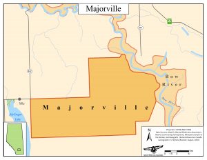
AWA’s Majorville area of concern occupies 416 km2 in the grasslands of southern Alberta. The area is known for its rich cultural history and abundant waterfowl habitat. Majorville is located approximately 40 km southwest of Brooks, Alberta, and can be accessed along Highways 842 or 847 via the TransCanada highway.
 Majorville Area of Concern. MAP © AWA: JPG | PDF
Majorville is located within the Carseland to Bassano sub-basin of the Bow River basin. The Bow River is one of the most significant waterways for urban and rural water supply, supporting one-third of Alberta’s residents.
Although man-made, one of the most significant water features within Majorville is the 36 wetland basins created by Ducks Unlimited. This restored wetland habitat supports a diverse array of waterfowl and migratory bird species.
The area surrounding Majorville is characterized by sedimentary deposits from the late-Cretaceous and Cenozoic eras, when the landscape was entirely submerged underneath the ocean. This Cretaceous bedrock has been deeply eroded into the 2 km wide valley surrounding the Bow River. One layer of marine deposits, known as the Bearspaw shales, is known to contain an abundance of fossils, such as ammonites and pelecypoda (clams). Above the Bearspaw Formation, coal seams have been located and extracted from by energy producers.
The area’s soft hills and leveled prairie landscape are the result of the glacial erosion during the Pleistocene. The gradual scraping and churning of ice sheets over the landscape resulted in the sand and gravel deposits that we see today, visually apparent in the many sand and gravel quarries nearby. The glaciers of the Pleistocene also deposited gravel erratics on the landscape, moving large, rounded gravel stones as far as 1000 km from their original location.
Information from the Medicine Wheel Project.
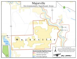
Much of Majorville is considered of national ecological significance, due to its extensive waterfowl habitat, productive nesting sites for at-risk birds of prey, and large, intact stretches of native grassland.
 Majorville ESAs. MAP © AWA: JPG | PDF
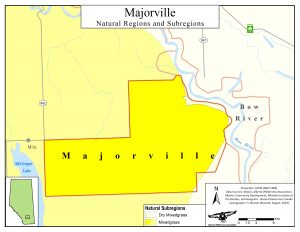
The Majorville area of concern is located within the Grasslands Natural Region of Alberta, containing primarily Mixedgrass, but also Dry Mixedgrass Subregions.
 Majorville Natural Regions. MAP © AWA: JPG | PDF
Mixedgrass Natural Region
The Mixedgrass Natural Region is dominated by needle-and-thread grass, sand grass, and low sedge, alongside salt grass and western wheat grass in the saline lowlands. Common shrubs include snowberry and prairie rose, and common forbs are pasture sage, golden bean, wildlife licorice and low goldenrod.
Dry Mixedgrass Natural Region
The plant communities of the Dry Mixedgrass Natural Region differ from the Mixedgrass Natural Region in that they reflect the warmer, drier grassland conditions. The dominant grasses are blue grama and needle-and-thread grass. The silver sagebrush communities of the dry mixedgrass region are particularly important for wildlife.
Information from the Range Plant Communities and Range Health Assessment Guidelines for the Mixedgrass Natural Subregion of Alberta (2013) and the Range Plant Communities and Range Health Assessment Guidelines for the Dry Mixedgrass Natural Subregion of Alberta (2013).
Majorville holds important nesting area for a large number of bird species, due to the wetland habitat created under the Medicine Wheel project (see Management, above). Species of particular concern that nest in the area include long billed curlew, great blue heron, chestnut collared longspur, black tern, American white pelican, prairie falcon, loggerhead shrike, Baird’s sparrow, red-necked grebe and Franklin’s gull. Other common bird species include burrowing owl, golden eagle, ferruginous hawk, snowy owls and rough-legged hawks. Alberta Fish and Wildlife have also reintroduced at-risk peregrine falcon, who have gone on to raise young in the area.
Other non-avian species living the Majorville area include mule deer and sensitive populations of plains spadefoot.
Information from the Medicine Wheel Project and the Government of Alberta.
Majorville holds one of oldest medicine wheels in Canada. The medicine wheel is estimated to be 5000 years old. Out of respect for this sacred site and the Blackfoot Peoples, visiting the area is discouraged.
Until the 1800s, the Blackfoot Confederacy roamed and controlled the Great Plains of present-day Alberta, extending south to the upper Missouri River in Montana. The Blackfoot Confederacy consists of three main groups, the Siksika, Kainai, and Piikani First Nations.
The management guidelines for Majorville encourage low-impact recreational activities such as wildlife viewing, hunting and hiking. As the guidelines state that the primary management objective for the area is to maintain wildlife populations and native prairie, off-highway vehicles are not permitted for game retrieval, and recreational camping and fires are not permitted within the area.
Lack of protection
Despite Majorville’s natural and cultural significance, there are no provincial or federal protections within the area. Majorville falls within the Grasslands Natural Region, which is one of the least protected Natural Regions in Alberta (1.25 percent protected as of June 2018) and simultaneously holds over half of Alberta’s species-at-risk within its plains, badlands, coulees and wetlands.
Since AWA’s took interest in Majorville, a number of oil and gas leases have been sold within the area, further infringing on this patch of sensitive native prairie. Alberta’s grasslands are threatened by growing urban and industrial footprints, gradually converting native grasslands for urbanization, energy extraction or agriculture. As Majorville falls within the public lands of Alberta’s White Area, its native prairies risk conversion into agricultural and energy leases. Without protection, the wilderness values of Majorville could be lost forever.
2015
The Government of Alberta releases the Majorville Guidelines for Land and Resource Management, operational guidelines adhering to the planning regime of the South Saskatchewan Regional Plan.
2003
AWA leads a party of 20 individuals on a tour of the Majorville area. Coordinated alongside Ducks Unlimited, participants of the tour included two interpreters, a paleontologist, and AWA staff.
2002-2003
AWA writes to the Minister of Energy on two separate occasions to request that two pending oil and gas leases within the Majorville area of concern not be sold.
1995
Ducks Unlimited and the Bow River Irrigation District undertake the Medicine Wheel project, flooding 384 hectares to create 36 wetland basins within the Majorville area. This project improves the quality of nesting habitat and cattle grazing.
1985
Ducks Unlimited and the Bow River Irrigation District identify the Medicine Wheel project as a priority for the area’s management.
1971
An archaeologist from the University of Calgary excavates the cairn at the center of the Majorville Medicine Wheel. Nearly 3000 artifacts are recovered from the 5000 year old structure.
1950s
The Government of Alberta installs an extensive canal system for flood irrigation and stock water. Due to minimal usage, the system eventually falls into disrepair.
1920s
Driven out by drought, the majority of settlers leave the Majorville area. As a result, many of the abandoned properties are forfeited to the Government for unpaid taxes. Left uncultivated, the grasslands return to their natural state.
1907
Homesteaders arrive in the Majorville area. By 1912, up to 50 homesteaders have settled the area.
Pre-contact
Following the retreat of the glaciers, Indigenous Peoples live and hunt on the Great Plains of Alberta. The Majorville Medicine Wheel exists as Canada’s oldest known cultural relic, used by the Blackfeet Peoples for over 5000 years.
June 15, 2012
Private members Bill 202 (2012) sponsored by MLA Dr. Neil Brown, Calgary-Nose Hill aimed at…
January 26, 2012
An astonishingly draconian Court Order is served on Albertans protesting the proposed logging in the…
May 25, 2010
The Suffield Coalition today expressed concern about the failure by the Government of Canada to…
March 12, 2010
As shale gas discoveries greatly expand already abundant reserves of natural gas, the economics of…
March 3, 2010
AWA Wilderness & Wildlife Defenders Alert, concerning draft Terms of Reference for Milk River Integrated…
March 3, 2010
AWA’s comments on the draft Terms of Reference for the Milk River Integrated Management Plan…
January 12, 2010
ENGO news release. The Suffield Coalition is disappointed to have learned last week that the…
April 1, 2008
Report by biologist Cheryl Bradley prepared for the Alberta Native Plant Council. 200804_AR2.pdf
February 1, 2008
Wild Lands Advocate article, February 2008, by Joyce Hildebrand 200802_AR_WL8.pdf
August 1, 2007
WLA August 2007 • Vol. 15, No. 4 200708_AR_WAT2.pdf
February 1, 2004
Wild Lands Advocate article, February 2004, by Cheryl Bradley 200402_AR_MR.pdf
October 1, 2001
Wild Lands Advocate article, October 2001, by Cliff Wallis 200110_AR_MR.pdf