
Droughts, Dams and Destruction
July 5, 2024
- •
- •
- •
It was controversial from the start, and a name change sought to hide it.
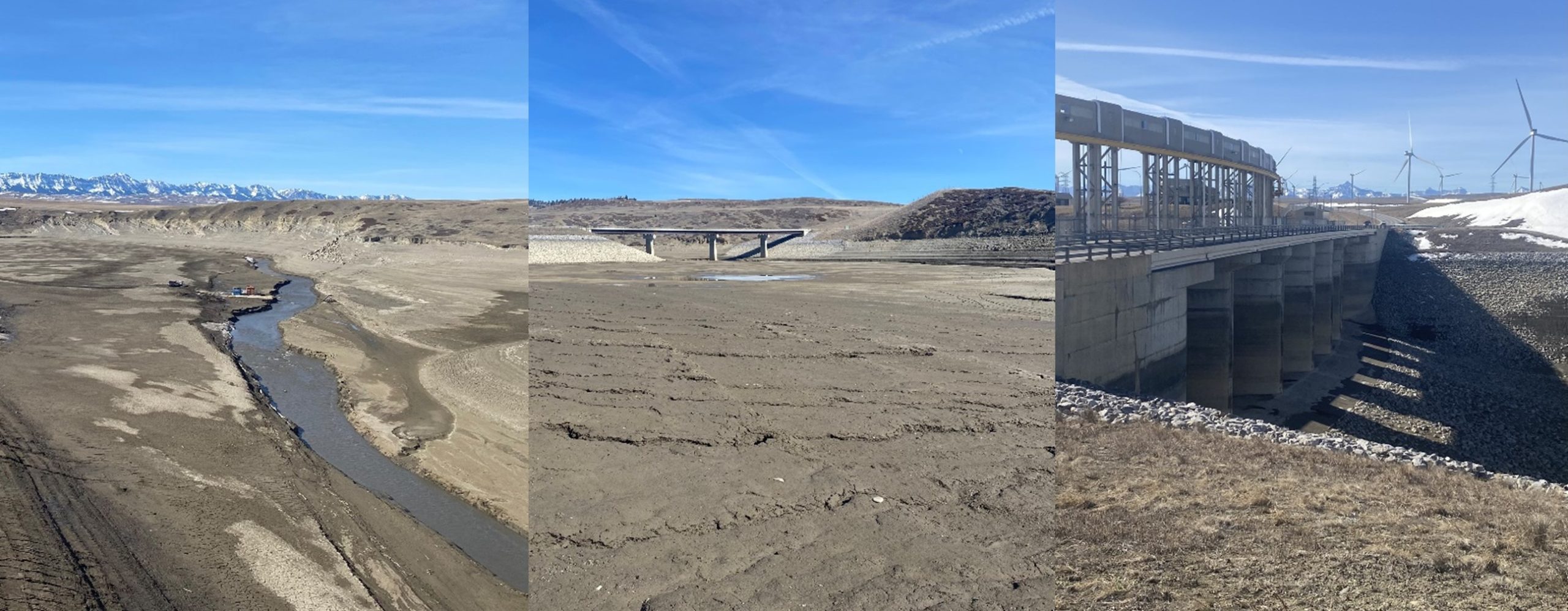
Left: Municipal District of Pincher Creek’s water intake on the Crowsnest River. Centre: Views of the dry reservoir from the North Fork Campground’s boat launch. Right: No water at the Old Man Dam. Photo © K. Halvorson
By Kennedy Halvorson.
Read the PDF version here.
When the Old Man reservoir was initially proposed, it was called Three Rivers, as it sits at the confluence of three major waterways. It was well known that disrupting the natural structure and flows of the Castle, Crowsnest, and Old Man Rivers with a dam would result in severe biodiversity loss and displace local livelihoods. Other potential sites had even been identified as suitable alternatives. But the ultimate location of the Old Man Dam, and its existence in general, is owed largely to the influence of irrigation.
Today, Southern Alberta is in a water crisis. Persistent, multi-year droughts have dried up watersheds and drained reservoirs. Wildfire season has become a synonym for summer. Reduced snowpack and early spring melts are symptomatic of increasingly warm, short winters, which are insufficient to recharge water stores. Despite this reality, other pressures and threats have not lessened and water demand continues. How did we get here? And how do we find our way out?
Let’s go back to the start of our troubles; it always comes back to colonialism. Enter John Palliser, a British geographer in the 19th century who characterized the prairie region as an arid desert, largely inhospitable to human settlement. Decades later, Irish settler and botanist James Macoun came to an entirely different conclusion; these lush plains were full of untapped farming potential, prime for the ploughing. A young, expansionist-minded Canadian government ran with the latter’s assertion. Eager to settle the west, native grasslands were doled out one-quarter parcel at a time.
So, who got it right? Someone kinder may say both, but does history give out half-marks when the knowledge was known, but the right people weren’t askpalled?
The long-standing histories of the Indigenous Nations populating the prairies present a pretty good argument against Palliser’s judgement, as do his own accounts. His expedition diaries call the region sterile in one breath then immediately recount game species and “wild fowl in great abundance,” bison “in great numbers,” and “bands of wolves” in another. These large and diverse wildlife populations would not be present if the landscape were truly barren, something well recognized by the Ĩyãħé Nakón mąkóce (Stoney Nakoda), Ktunaxa ɁamakɁis (Kootenay), Očhéthi Šakówiŋ (Sioux), Nêhiyaw-Askiy (Plains Cree), Niitsítpiis-stahkoii (Blackfoot), Tsuut’ina, and other Indigenous peoples living within the region.
Later, Macoun would challenge the “valuelessness” ascribed to the prairies, providing misleading representations from the opposite end of the spectrum. Having visited in a time of above-average summer precipitation, his autobiography details land blessed with an “abounding fertility” and exceptional climate for agricultural productivity, potentially “unsurpassed in any other part of the world.” He argued that the “apparent aridity” of the region was caused by a lack of tillage, and that “the first efforts of husbandry” would allow the “abundance of rain … to penetrate the ground” and bear “excellent crops of all kinds.” His observations reflect significant misunderstandings of how grassland ecosystem’s function and foreshadow the critical errors that led to the infamous 1930’s dustbowl.
In a push to expand and establish Canada’s dominion in North America, the prairies were continually branded as the ideal place for aspiring agriculturists, despite a growing awareness of the region’s frequent droughts. Ground fertilized by centuries of native grass growth was ploughed extensively by subsequent settlers. Their husbandry practices disrupted and degraded the structure of soil that had previously been fortified by the region’s deep-rooted plants. Unlike the cultivated crops that would go on to replace much of the region’s prairies, native grasses are acutely adapted to a climate with limited precipitation and extreme temperatures, storing much of their biomass deep underground in the form of roots where moisture and temperatures are more stable. This mechanism also allows the plants to rebound quickly from natural disturbances. Through consuming the vegetative litter and residues above ground, bison herds and fires freed up room for energy dense roots to push out new growth, starting the cycle anew. In the absence of native grasses like blue grama (Bouteloua gracilis), hairy wild rye (Elymus innovatus), and Foothills rough fescue (Festuca campestris), strong winds turned soil to dust, creating an environmental and economic disaster that plagued the prairies for almost a decade.
Palliser and Macoun pegged the prairies wrong because they couldn’t understand the landscape outside their colonial lens. Since time immemorial, these grasslands sustained innumerable wildlife populations (over 30 million bison alone!) and all the Indigenous peoples who depended on them. Prairie ecosystems are powerhouses. They are habitable, ecologically productive, AND water scarce; these concepts are not mutually exclusive, and the continuous failure to understand that has led to Southern Alberta’s current predicament. By the time the extent of the water scarcity in the prairies was recognized (surprisingly, rain did not follow the plough), agricultural settlements were well established. And those farmers demanded water.
Cue irrigation.
Time really does feel like a flat circle
Here’s a scenario: Imagine parts of Alberta, let’s say the south eastern corner, are going on year three or four of drought conditions. And let’s say, economically, politically, socially, environmentally, just generally, times are tough. They’re particularly hard for farmers growing crops and ranchers raising livestock. Imagine now, there are calls for government action, calls to support producers, calls to protect agricultural livelihoods and communities. The calls are underlined with the assertion that if they’d been better prepared, invested in better water management and infrastructure, built more reservoirs, dams, and canals, built more irrigation, this whole situation could have been avoided. Now imagine it’s 1890. Or 1921. 1937, 1984, 2002. It’s 2024 and the grooves of this scenario are well worn, Alberta has been here before and will be here again. The outcome is almost predetermined too. Over a century of experience seemingly offers but a single solution; stop the rivers and flood the valleys.
Now we’ve found our way to the Old Man again. Exemplifying Alberta’s response to environmental emergencies, the reservoir was forced through in the late 1980s to early 1990s following the latest multi-year drought, against the best available science and the government’s internal recommendations. High-quality cottonwood ecosystems and native trout habitat were destroyed. Those living where the three rivers converged were displaced. The Piikani lost access and use of culturally important lands beneath the reservoir’s depths — to say Indigenous consultation was wholly insufficient is a laughable understatement. But no need to rehash the exact details of the sordid tale. Longtime AWA members know the story, and for those interested, Jack Glenn’s Once Upon an Oldman and Robert Girvan’s Who Speaks for the River? are well worth the read. The key takeaway is that the dam was supposedly the answer to making water availability more reliable for irrigation.
It may be surprising to learn that only 5.8 percent of cultivated land in the province is irrigated. Many are under the impression that all agriculture in Alberta relies on the practice, considering 45 percent of all water allocated in the province is for irrigation. The majority of irrigated hectares are concentrated within the 11 Irrigation Districts (IDs), which are located in the South Saskatchewan River Basin. This watershed has been closed to new water licences and allocations since 2007, when it was recognized that its rivers and streams had been well overallocated and instream flow needs were regularly not being met. Despite this recognition, existing allocations have not been meaningfully reduced.
In 2022, the IDs diverted 2.5 billion cubic metres out of Alberta’s southern watersheds. Of this, over 1.8 billion cubic metres were used for irrigation. The irrigation infrastructure in the region is extensive; 8,000 kilometres of pipelines and canals transverse the landscape, connecting 56 reservoirs (with a total live storage capacity of 2.9 billion cubic metres) to the rivers and croplands. 236 million cubic metres, or 2.5 percent of Alberta’s total annual allocated volume, was lost through evaporation and seepage from ID infrastructure alone.
One-fifth of all water available for use in the province watered less than five percent of Alberta’s cultivated area. Considering water is precious, essential, and increasingly threatened, how do we justify using so much of it on such a small proportion of our agriculture? Given that irrigation increases crop yield per hectare, maybe this seemingly disproportionate input would be justified if ID’s produced a large proportion of Alberta’s crops or ones that fill gaps in the province’s food security. Economic justifications are less compelling; even if IDs contributed significantly to overall agricultural GDP, that would need to be balanced against the maintenance of irrigation infrastructure and the hidden costs associated with removing water from the river systems, as well as the value lost through the river basin’s reduced capacity to provide ecosystems services.
The Oldman Reservoir pictured in April 2024, mostly empty. Photo © K. Halvorson
Consider the downstream impacts of these massive diversions — how much do water treatment facility costs increase without sufficient volumes to dilute pollutants? What about the costs of fish stocking programs, which release hatchery-reared species into the watersheds to reduce angling pressures on wild fish populations, who may otherwise be robust under natural flow conditions? Or the costs of erosion control and riparian habitat restoration? What does it cost when low river volumes force communities to reroute their intake pipes or truck in water over great distances? What about the value lost when weakened river systems cannot effectively cool the atmosphere, filter water, or support plants that produce oxygen, store carbon, and enrich the soil? These realities quickly complicate the cost-benefit analysis of irrigation.
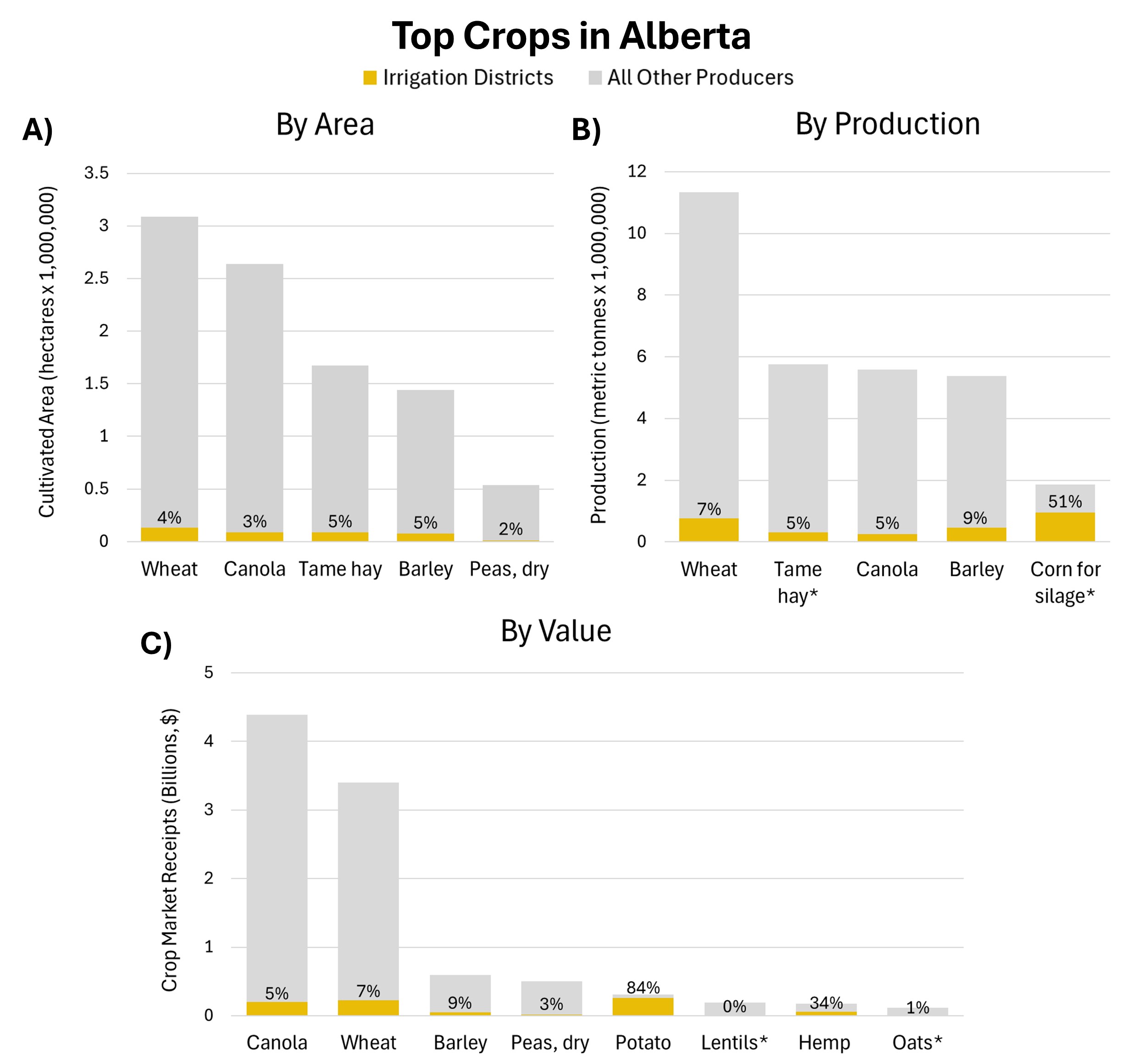
Crop production in the Irrigation Districts
In 2022, Alberta’s largest crops by area were wheat, canola, tame hay, barley, and dry peas, of which a small proportion were located within the IDs. This is understandable as these are crop types that are productive on dryland operations. Crops found predominately on ID lands included dry beans (96 percent), sugar beets (89 percent), potatoes (85 percent), and corn for grain (100 percent) and silage (51 percent), which are all crops that require greater volumes of water than average precipitation affords in southern Alberta. The input of additional water allows irrigators to grow more than 60 different varieties of crops on their lands, compared to the 29 types that grow on dryland farms.
Another benefit of irrigation is increased yields, so understanding its impact on Alberta’s agriculture requires a comparison of crop production totals. Of Alberta’s largest crops, comparisons of IDs area and production percentages demonstrate IDs did produce more on less land, but still made up relatively small proportions of the total crop production, except for corn silage. Looking at some of Alberta’s smaller crops, IDs contributed significantly to the province’s potato yields, producing 84 percent of potatoes, or more than 1 million tonnes, as well as 87 percent of sugar beets, equivalent to almost 880,000 tonnes. They would be responsible for the same percentage of total crop market receipts, and of the crops with market receipts reported, IDs had large proportions of potatoes and hemp sales, estimated to be $260 million and $60 million respectively.
Otherwise, dryland operations produced most of Alberta’s crops and crop value, including over $7 billion worth of canola and wheat. This is the economy of scales; while irrigated cropland is technically more productive, Alberta has far more dryland operations that grow the majority of the province’s crops, and well beyond what is needed to feed the province (while Alberta is a surplus producer of many crops and livestock there are some major deficiencies; the province only produces five percent of the fruits and vegetables we consume). One strategy uses a massive amount of land, while the other relies on enormous inputs of water. Neither of which are sustainable — a deep dive into the environmental issues associated with agricultural intensification will have to wait for another article — but ultimately, the most pressing issue is that there is an extremely limited amount of water in Alberta, of which a massive amount is controlled by a small sector demanding more.
The Old Man’s lessons
At the start of spring, the Old Man Reservoir sat at 30 percent of its capacity, the lowest volumes recorded since it began operating in 1992. Upstream, diminished flows carve through landscapes devoid of riparian habitat and decades of accumulated silt and sediment; evidence of bank erosion laid bare. Years of consecutive drought and over-allocating water have emptied the reserves, revealing that fatal flaw; reservoirs don’t make more water. Eight more reservoirs are proposed as the solution; proponents insist if we could just store more water, use every last drop, drought would not be an issue. But considering the amount of storage capacity already dedicated to irrigation, how much more can the industry need? And if more reservoirs and dams were the solution, why haven’t existing ones been enough? The ID’s excessive demand and use of water jeopardizes entire river basins for the production of cash crops, while their endless push for expansion threatens to gobble up the few tracts of native grasslands that remain.
The unfortunate reality is that we are living well beyond our ecological means. Farming water-intensive crops in the arid prairies should be recognized as an inappropriate land use for the region — Palliser was right about that. The amount of water removed from these rivers is not sustainable. To continue to do so is to our own detriment, and what’s most frustrating is that we were well-warned. Alberta’s foremost water experts, the late Dr. David Shindler and Dr. Bill Donahue outlined Alberta’s impending water crisis back in 2006, noting that:
“The cumulative effects of climate warming, drought, and human activity have seldom, if ever, been considered by land managers and policy makers. There is little integrated catchment planning in the Western Prairie Provinces, and science is poorly represented in the planning process. Generally, decisions to expand cities, clear forested land, fill in wetlands, place and construct feedlots, approve major industrial projects and expansions, apply fertilizer, apportion water supplies, and expand cottage developments are made on a project-specific basis… Ecological instream flow needs and lake levels are often ignored or underestimated… As problems arise, reactionary solutions are derived piecemeal, usually by different departments and levels of government, and too late for easy, inexpensive, or timely remediation.”
If we want to continue to have the climate resilience and ecosystem services healthy river basins afford, Alberta needs to drastically reconsider how and where water is used. Integrated watershed management that prioritizes the environment first is integral. While Schindler and Donahue’s warning wasn’t taken seriously back then, there is still the opportunity to use their advice now. Watershed integrity must be rapidly repaired and protected through the restoration and conservation of headwater forests, wetlands, and riparian areas. Limiting the rate of glacial wastage and snowpack disappearance requires Alberta to seriously reduce greenhouse gas emissions, of which oil and gas is by far the largest contributor. Agricultural activities that require substantial water volumes, like irrigation expansion, should not be pursued, particularly during times of water scarcity.
Most of all, we need to learn from past mistakes and right old wrongs. The Old Man Dam should be evidence enough; Alberta cannot keep bending the environment to its own will, or it will break.