How Much of Alberta is Left for Renewable Energy?
September 18, 2024
- •
- •
- •
A Review of the Enacted, Proposed and Potential Limitations on Renewable Energy Development in Alberta
The full report, references and data sources are available here.
Executive Summary
Alberta is a province with abundant sun and wind, two conditions which have drawn investment in renewable energy development, particularly solar panels and wind turbines. However, recent policies have dampened investment by creating uncertainty and severely reducing the land available for renewable energy installations. In addition to the restrictions already imposed on this industry, new policies are still being developed that could further curtail wind and solar developments. To better understand the imposed and potential limitations on renewable energy development, we mapped the potential restrictions based on the suggestions and examples in Renewable Energy Development on Agricultural Land Presentation, a webinar presented by the Government of Alberta. We further analysed the area and proportion of Alberta’s land these restrictions could affect. From this analysis, we determined that renewable energy development could be prohibited from 36 to 39 percent of the province, with restrictions heavily focused in the prairie region, where sun and wind resources are particularly concentrated. These restrictions are proposed solely for renewable energy and would not impact the fossil fuel industry or other developments, such as urban expansion. As such, these restrictions would serve only to slow Alberta’s energy transition, with little impact on protecting sensitive lands still threatened by other industries.
Introduction
Renewable energy development is a vital part of reducing Alberta’s emissions and transitioning to clean energy. Alberta has stated an aspiration “to achieve a net zero carbon neutral economy by 2050” (Government of Alberta, 2024) in line with Canada’s commitments to net-zero emissions by 2050. Oil and gas production is the largest emitting sector of Alberta, responsible for 59 percent of our province’s carbon emissions and totaling 158.3 MT CO2e (megatonnes carbon dioxide equivalents; Canada Energy Regulator, 2024). Reducing fossil fuel production and transitioning to renewable energy is the fastest and most effective method of decarbonizing Alberta’s energy system.
Yet, recent policies have not supported this transition. Last year, Albertans were surprised by the provincial government’s decision to implement a seven-month pause on renewable energy development (Government of Alberta, 2023a). There were accusations of favoritism for the oil and gas sector, accusations that only grew when the moratorium ended, and additional restrictions were announced for wind and solar developments (Neudorf, 2023). These new restrictions were not applied to fossil fuels, despite the Alberta Utilities Commission (AUC) recommendations for “industry agnostic” restrictions that “apply equally to all forms of development within the restricted zone, not just electricity generation” (Alberta Utilities Commission, 2024). These restrictions are arbitrary, did not follow the recommendations made by AUC after extensive public consultation, and are not based on science.
On July 24, 2024, Alberta’s Natural Resource Management Branch provided their Renewable Energy Development on Agricultural Land Presentation. The Renewable Energy Development on Agricultural Land Engagement opened an official engagement survey for “municipalities, renewable energy companies and agricultural landowners, including First Nations and Métis private landowners.” No method of commenting on the potential changes was provided for other interested parties, including environmental organizations, scientists and concerned communities.
The focus of these new restrictions and the engagement survey was on renewable energy use of agricultural land, native grassland protection, and use of irrigated or irrigable lands. Examples of further restrictions included a ban on all quarter-sections with over 30 percent native prairie, as well as prohibitions on irrigated land and lands deemed suitable for irrigation. Also suggested was the requirement to maintain 80 percent of prior agricultural production on Class 1 or 2 Agricultural Lands, effectively preventing renewable energy development on these lands.
AWA wanted to understand how much of Alberta the imposed and potential restrictions would cover. First, we look at the land no longer available to renewable energy development due to the protection of “pristine viewscapes.” We then consider two potential scenarios involving native prairie and irrigable lands. In the first scenario, we assume a ban on lands containing 30 percent or greater native prairie refers only to upland prairie, and irrigable lands to be avoided include any lands that are considered 100 percent irrigable, regardless of the irrigation rating itself. In the second scenario, we include uplands and wetlands in our calculation of native prairie, and incorporate lands that contain an irrigation rating or “Good” or “Excellent” covering at least 50 percent. Both scenarios include all Class 1 and 2 agricultural land, and currently irrigated lands.
1. Restrictions Imposed On Renewable Energy Developments – Protection of “Pristine Viewscapes”
In February, Alberta imposed 35-km buffers around regions designated “pristine viewscapes” where wind development was forbidden, and solar developments would require a Visual Impact Assessment. While this initially appeared to apply to all Parks and Protected Areas, the restriction was eventually reduced to a buffer surrounding the Rocky Mountains, and requirements for Visual Impact Assessments around specified sites. In total, these restrictions covered an area of 149, 831 km2, roughly 22.61 percent of the province.
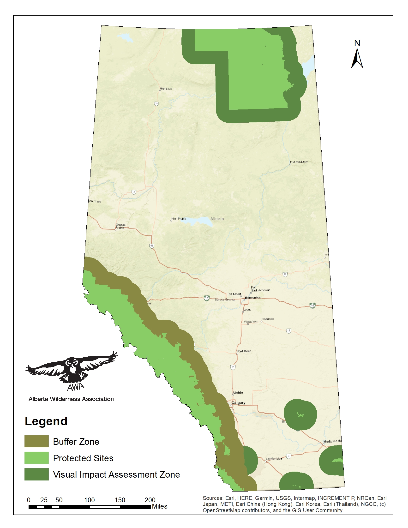
Figure 1. “Pristine viewscape” sites under protection and buffer zones in Alberta. Protected sites indicate sites selected by the government for their viewscapes. Buffer zones of 35-km show regions where wind developments are forbidden, or where Visual Impact Assessments are required for development.
2. Potential Restrictions on Renewable Energy Developments – Agricultural Lands, Irrigation, Native Grassland
Additional restrictions on agricultural lands, irrigated lands and native grasslands are a central component of the recent engagement survey. The requirement for “co-existence” with agriculture on Class 1 and 2 lands was established in February 2024. However, the definition of “co-existence” was not defined at the time. In the Renewable Energy Development on Agricultural Land Presentation webinar, “co-existence” was suggested as maintaining 80 percent of average agricultural production post-installation as pre-development – a high expectation that would likely prohibit renewable energy on most Class 1 and 2 lands.
The webinar also discussed protection of native grasslands and irrigated lands. One example for protection was to avoid renewable energy development on any quarter-section with at least 30 percent native grassland. Another proposed policy was to avoid lands currently under irrigation, and require a suitability assessment for irrigation for all other lands, with the possibility of excluding lands appropriate for irrigation. We calculated the area and percent of lands in Alberta that these example restrictions would affect.
Table 1. Area and percent of Alberta covered by potential restrictions.
| Restriction | Area (km2) | Percent (%) |
| Class 2 agricultural lands | 45,977 | 6.937 |
| Native prairie – uplands only | 5,226 | 0.789 |
| Native prairie – uplands and wetlands | 47,719 | 7.201 |
| Irrigated lands | 8,660 | 1.307 |
| 100% irrigable land | 31,219 | 4.711 |
| 50% good or excellent irrigation potential | 53,723 | 8.106 |
We further examine possible scenarios involving these restrictions below.
2.1 Scenario 1 – Excluding Class 2 Agricultural Lands, Upland Native Prairie, Irrigated and 100% Irrigable Lands
Assuming native grasslands refers only to upland native prairie, we determined the percent of upland prairie in each quarter-section and selected for only quarter-sections with greater than 30 percent upland prairie. For irrigation, we selected only for lands where 100 percent of the area was considered “Irrigable.” We did not consider the quality of irrigation, defined as either “Fair,” “Good,” or “Excellent.” (See Appendix A for more information on data sources). We included in our analysis lands currently under irrigation, and all Class 1 or 2 agricultural land. These restrictions covered an area of 81,444 km2 or 12.30 percent of the province.
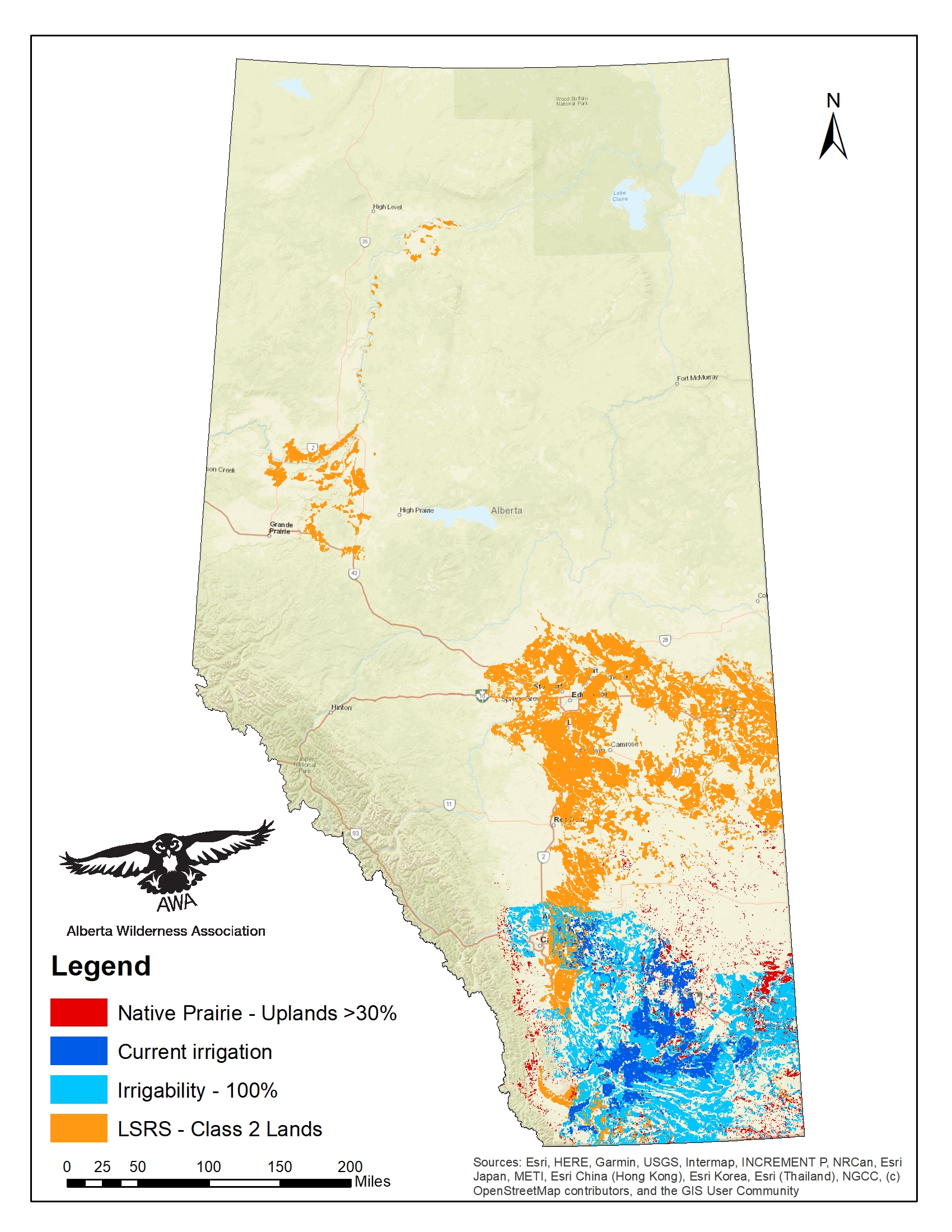
Figure 2. Map of Alberta showing Scenario 1 restrictions. Includes Class 2 Agricultural Lands, quarter-sections containing 30 percent or greater upland prairie, sections currently under irrigation, and sections with 100 percent of land considered irrigable. Included sections indicate where renewables may be prohibited under new regulations.
2.2 Scenario 2 – Excluding Class 2 Agricultural Lands, All Native Prairie, Irrigated Lands and Lands with Over 50 percent Good or Excellent Irrigation Potential
Assuming native grasslands refers to both wetland and upland native prairie, we used the sum of upland and wetland areas and determined the percent of total native prairie in each quarter-section, selecting for only quarter-sections with greater than 30 percent upland prairie. For irrigation, we selected only for lands where irrigation suitability was considered “Good,” or “Excellent” in at least 50 percent of the area. (See Appendix A for more information on data sources). We included in our analysis lands currently under irrigation, and all Class 1 or 2 agricultural land. These restrictions covered an area of 113,727 km2 or 17.16 percent of the province.
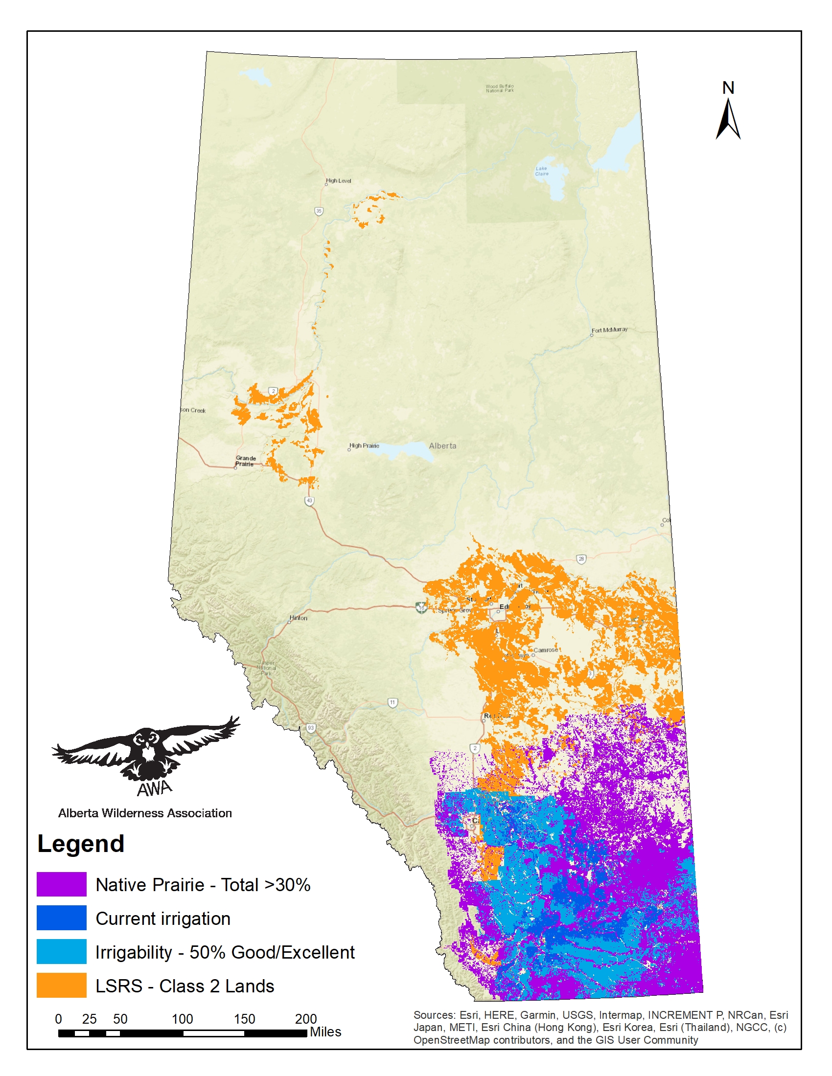
Figure 3. Map of Alberta showing Scenario 2 restrictions. Includes Class 2 Agricultural Lands, quarter-sections containing 30 percent or greater native prairie, sections currently under irrigation, and sections with at least 50 percent of land considered good or excellent irrigability. Included sections indicate where renewables may be prohibited under new regulations.
3. Including Buffer Zones and Protected Areas in Analysis
Building from the scenarios explored in Section 2, we incorporated the “pristine viewscape” restrictions already imposed on renewable energy to explore the total area that would be unavailable to renewable energy with the additional restrictions. We also assumed that renewable energy development will not be allowed in Alberta’s Parks and Protected Areas, which have been included in our area calculations.
3.1 Scenario 1 with Pristine Viewscape Buffer Zones
Incorporating the protection on “Pristine Viewscapes” (Section 1), restrictions described in Scenario 1 (Section 2.1), and current Parks and Protected Areas, the restrictions will cover 239,351 km2 or 36.12 percent of the province.
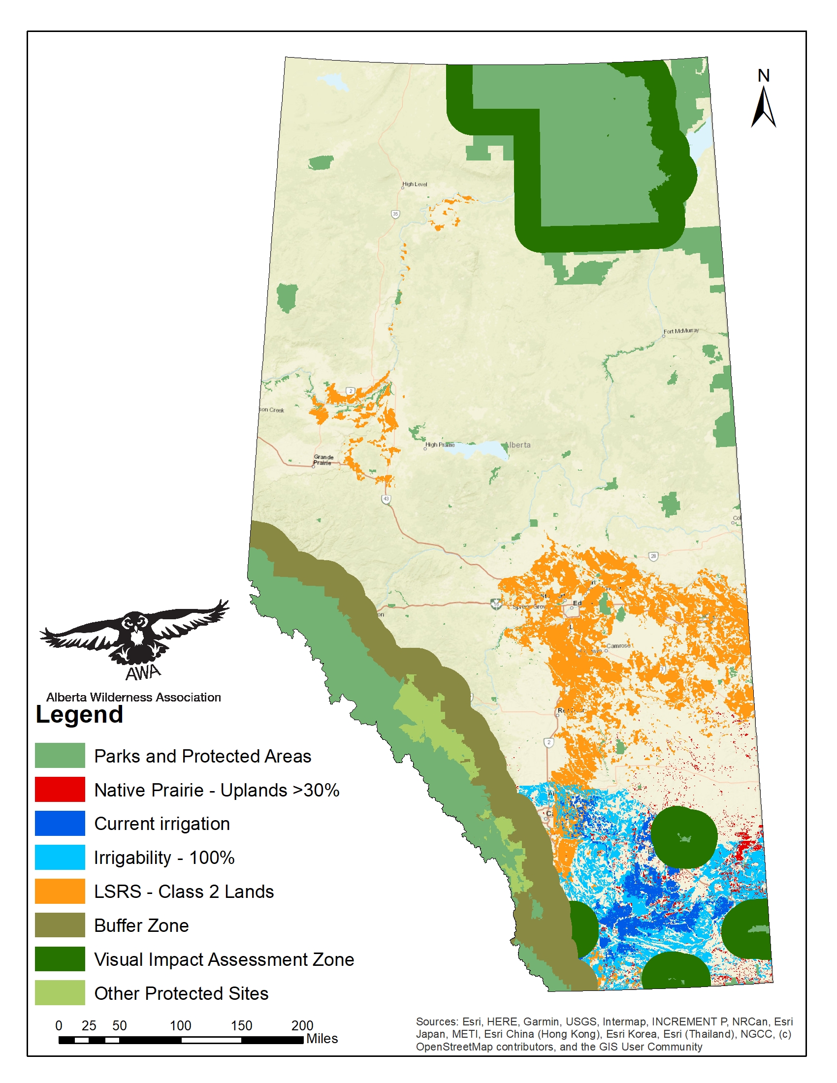
Figure 4. Map of Alberta showing Scenario 1 restrictions with pristine viewscape buffers. Includes Class 2 Agricultural Lands, quarter-sections containing 30 percent or greater upland prairie, sections currently under irrigation, and sections with 100 percent of land considered irrigable, as well as buffers around designated “pristine viewscapes” and Parks and Protected Areas.
3.2 Scenario 2 with Pristine Viewscape Buffer Zones
Incorporating the protection on “Pristine Viewscapes” (Section 1), restrictions described in Scenario 2 (Section 2.2), and current Parks and Protected Areas, the restrictions will cover 260,907 km2 or 39.37 percent of the province.
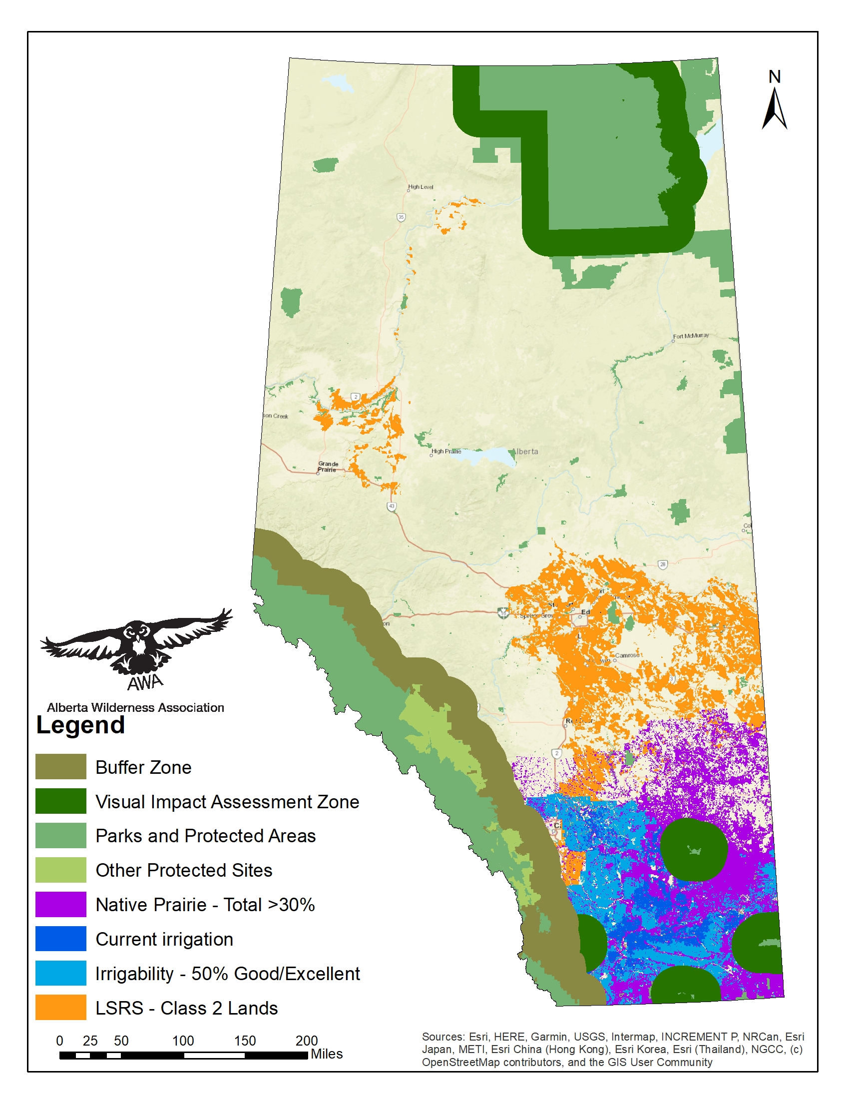
Figure 5. Map of Alberta showing Scenario 2 restrictions with pristine viewscape buffers. Includes Class 2 Agricultural Lands, quarter-sections containing 30 percent or greater native prairie, sections currently under irrigation, and sections with at least 50 percent of land considered good or excellent irrigability, as well as buffers around designated “pristine viewscapes” and Parks and Protected Areas.
Conclusion
Based on the examined scenarios for new restrictions on renewable energy developments regarding native grassland, agricultural land and irrigated or irrigable land, we might expect an additional 12 to 17 percent of Alberta would no longer be open to development. Including the restrictions that have already been applied, and assuming developments will not occur in Parks and Protected Areas, renewable energy development could be barred from 36 to 39 percent of the province.
Additionally, these potential restrictions are largely focused on Alberta’s prairies, consisting of the grassland and parkland ecoregions. These areas are often favoured by renewable energy developers for their abundant sun and wind resources. As such, severe restrictions on development in the prairie region could effectively halt new renewable energy development and curtail the energy transition Alberta needs to reach net-zero emissions.
AWA has long advocated for the protection of native prairie – both uplands and wetlands – and we agree with limiting industrial development on agricultural lands. However, renewable energy is not the greatest threat to these lands. Extensive losses in native grassland have been due to settlement and plowing of lands for row crops, with the World Wildlife Fund finding 1.6 million acres of grassland across North America were plowed in 2021, and 32 million acres have been plowed since 2012 (World Wildlife Fund, 2023). The construction of irrigation infrastructure and reservoirs has caused further loss of native prairie through flooding. Many other competing land uses threaten the native prairie landscape and the sustainability of agricultural lands, including oil and gas exploration, coal, gravel, and other mining operations, and expansion of roads and other infrastructure. Urban and rural municipalities have also seen extensive growth, with an increase of 43,634 ha in urban land use and 29,777 ha in rural residential land use (Government of Alberta, 2023b). Alberta Biodiversity Monitoring Institute (ABMI) noted in The Status of Human Footprint in Alberta report that 60.6 percent of the grassland natural region was occupied by human footprint as of 2021, covering 57,923 km2. Wind and solar developments cover roughly 32 km2 (Pembina Institute, 2023), and just over 38,000 acres or 154 km2 would be needed to reach net-zero goals, roughly 0.08 percent of total agricultural land in the province (Hastings-Simon et al, 2023).
For effective protection, restrictions need to be applied equally across all industries, and should use science-based understanding to determine regions and thresholds where development must be limited. Healthy native prairie ecosystems require large, intact sections of relatively undisturbed land and sufficient connections between habitats. The current restrictions use arbitrary thresholds not supported by science, and as previously, there is no indication that these restrictions will be applied to the more destructive oil and gas or mining industries and other environmentally harmful developments. As such, they will fail to provide protection for Alberta’s sensitive ecosystems or agricultural lands.
The hinderance of renewable energy growth contradicts promises for reducing carbon emissions and protecting biodiversity, as well as impacting environmental and human health, and incurring future costs and consequences for Alberta’s growth. Continued fossil fuel extraction extensively harms the environment, through disturbance, pollution, and the release of greenhouse gas emissions during use. Over $33 billion in liabilities – the amount required to properly abandon, clean-up and remediate the land – is estimated for the oil and gas industry (Alberta Energy Regulator, 2024). In addition, burning of fossil fuels is one of the greatest sources of pollutions, particularly in urban areas. Globally, fossil fuels cause an estimated 6.7 premature deaths annually, and resulted in $2.9 trillion in health and economic costs in 2018 (World Health Organization, 2024). Additionally, rising greenhouse gas emissions are contributing to climatic changes, leading to more severe and frequent weather events which can damage infrastructure, equipment, and property (Canadian Institute for Climate Choices, 2020), as well as affecting agricultural harvest and food prices. The longer energy transition is delayed, the higher these costs will become.
We recognize a need for a rapid energy transition away from fossil fuel use and support responsible and well-sited renewable energy development. We recognize also a need to balance protection of vital natural regions and biodiversity with development. However, the current and proposed regulations are arbitrary and purposeless, and will be inadequate to protect sensitive lands while striking at Alberta’s progress towards clean energy. These policies will result in further harm to sensitive habitats, environmental and human health, and economic growth.